Nevada State Route 278
| ||||
|---|---|---|---|---|
| Eureka–Carlin Road | ||||
 | ||||
| Route information | ||||
| Maintained by NDOT | ||||
| Length: | 87.630 mi[1] (141.027 km) | |||
| Existed: | 1976 – present | |||
| History: | Part of SR 20 by 1929, changed to SR 51 by 1965; Became SR 278 in 1976 | |||
| Major junctions | ||||
| South end: |
| |||
| North end: |
| |||
| Location | ||||
| Counties: | Eureka, Elko | |||
| Highway system | ||||
| ||||

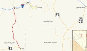
State Route 278 (SR 278) is a state highway in Nevada. It runs from U.S. Route 50 (US 50) near Eureka north to Interstate 80 (I-80) in Carlin.
Route description
_in_Eureka_County%2C_Nevada.JPG)
State Route 278 begins at a junction with US 50, about 3 miles (4.8 km) north-northwest of Eureka in southern Eureka County. The highway heads north-northwest from there, passing by the Eureka Airport and going through Diamond Valley. After about 15 miles (24 km), SR 278 curves westward to run between the Whistler and Sulphur Springs Ranges, turning north and cresting Garden Pass to enter Garden Valley.[2][3]
SR 278 continues heading northward, eventually entering Pine Valley. After several miles, the highway shifts slightly more eastward as it approaches the Cortez Mountains and the Pinon Range.[2][4] The route follows a creek northwestward, then curves to follow the path of the Humboldt River and Union Pacific Railroad northeastward. The route enters Elko County and soon after enters the city of Carlin. State Route 278 ends on the western edge of Carlin at West Carlin interchange on I-80 (exit 279).[2][5]
History


A route approximating the alignment of Eureka–Carlin Road appeared on state highway maps as a narrow, unimproved roadway as early as 1927.[6] By 1929, this road had been designated as State Route 20, and was shown to parallel the Eureka and Palisade Railroad connecting Eureka to State Route 1/US 40 (today's I-80) further west of Carlin via Palisade.[7] SR 20 was mostly upgraded to a gravel road by 1946[8] Except for the portion between Palisade and US 40, the road was completely paved by 1956—a road connecting just south of Palisade directly to Carlin (approximating today's alignment of the northernmost reaches of SR 278) was also paved by this time.[9] The Eureka–Carlin road portion of SR 20 was renumbered as part of State Route 51 by 1965.[10]
The Eureka–Carlin road remained unchanged for several years after being renumbered to SR 51. However, the Nevada Department of Transportation began renumbering its state highways in the mid 1970s. On July 1, 1976, the road was renumbered again, to State Route 278, the designation it carries today.[11] The number change was first seen on official state highway maps in 1978.[12] The route has remain substantially unchanged since then.
Major intersections
| County | Location | mi | km | Destinations | Notes |
|---|---|---|---|---|---|
| Eureka | | 0 | 0.0 | Southern terminus | |
| Elko | Carlin | ||||
| Northern terminus; I-80 exit 279 | |||||
| 1.000 mi = 1.609 km; 1.000 km = 0.621 mi | |||||
See also
 Nevada portal
 U.S. Roads portal
References
| Wikimedia Commons has media related to Nevada State Route 278. |
- ↑ "State Maintained Highways of Nevada: Descriptions and Maps". Nevada Department of Transportation. January 2015. Retrieved January 17, 2016.
- 1 2 3 Google (January 17, 2016). "Overview of SR 278" (Map). Google Maps. Google. Retrieved January 17, 2016.
- ↑ Nevada Department of Transportation (2015). Quadrangle 5-5 – General Highway Map: Eureka County (PDF) (Map). Cartography by Location Division, Cartography Section. Retrieved January 17, 2016.
- ↑ Nevada Department of Transportation (2015). Quadrangle 4-5 – General Highway Map: Eureka County (PDF) (Map). Cartography by Location Division, Cartography Section. Retrieved January 17, 2016.
- ↑ Nevada Department of Transportation (1992). Quadrangle 3-5 (Provisional) – General Highway Map: Eureka and Elko Counties (PDF) (Map). Cartography by Location Division, Cartography Section. Retrieved January 17, 2016.
- ↑ S.C. Durkee (1927). Highway Map of the State of Nevada (Map). Nevada Department of Highways. Retrieved January 17, 2016.
- ↑ S.C. Durkee (1929). Highway Map State of Nevada (Map). Nevada Department of Highways. Retrieved January 17, 2016.
- ↑ Official Road Map of the State of Nevada (Map). Nevada Department of Highways. 1946. Retrieved January 17, 2016.
- ↑ Official Highway Map of Nevada (Map). Nevada Department of Highways. 1956. § C5, D5. Retrieved January 17, 2016.
- ↑ Official Highway Map of Nevada (Map) (1965–1966 ed.). Nevada Department of Highways. 1965. § C5, D5. Retrieved January 17, 2016.
- ↑ Nevada's State Maintained Highways: Descriptions, Index and Maps. Nevada Department of Transportation. January 2001.
- ↑ Official Highway Map of Nevada (Map) (1978–1979 ed.). Nevada Department of Highways. 1978. § B4, C4. Retrieved January 17, 2016.