Nevada State Route 121
| ||||
|---|---|---|---|---|
| Dixie Valley Road | ||||
|
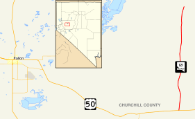
Nevada State Route 121, highlighted in red. | ||||
| Route information | ||||
| Maintained by NDOT | ||||
| Length: | 26.951 mi[1] (43.373 km) | |||
| Existed: | 1976 – present | |||
| Major junctions | ||||
| South end: |
| |||
| North end: | Settlement Road in Dixie Valley | |||
| Location | ||||
| Counties: | Churchill | |||
| Highway system | ||||
| ||||

State Route 121 (SR 121) is a state highway in Churchill County, Nevada. It spurs from U.S. Route 50, east of Fallon, north 26.951 miles (43.373 km) to a local highway, Settlement Road in Dixie Valley, with the moniker of Dixie Valley Road. SR 121 was assigned in 1976.
_in_Churchill_County%2C_Nevada.JPG)
Route description
State Route 121 begins at an intersection with U.S. Route 50 (the Austin Highway) to the east of the community of Fallon. Route 121 progresses northward through the United States Naval Recreation and Training Area just to the north of Route 50. The route progresses northward, through the mountains of Churchill County. The highway leaves the Recreation Area and continues its way to the community of Dixie Valley. The route continues northward for about 20 miles (32 km) and intersects with Settlement Road in Dixie Valley, where the state designation ends. Dixie Valley Road continues on as a gravel road.[2]
Major intersections
The entire route is in Churchill County.
| Location | mi | km | Destinations | Notes | |
|---|---|---|---|---|---|
| Fallon | 0.00 | 0.00 | |||
| Dixie Valley | 26.951 | 43.373 | Settlement Road | ||
| 1.000 mi = 1.609 km; 1.000 km = 0.621 mi | |||||
See also
 Nevada portal
 U.S. Roads portal
References
- ↑ Nevada State Maintained Highways, Descriptions, Index and Maps page 105
- ↑ Google (June 6, 2015). "Overview of State Route 121" (Map). Google Maps. Google. Retrieved June 6, 2015.
| Wikimedia Commons has media related to Nevada State Route 121. |