National Register of Historic Places listings in Bibb County, Georgia
This is a list of properties and districts in Bibb County, Georgia that are listed on the National Register of Historic Places (NRHP).
- This National Park Service list is complete through NPS recent listings posted December 16, 2016.[1]
Current listings
| [2] | Name on the Register | Image | Date listed[3] | Location | City or town | Description |
|---|---|---|---|---|---|---|
| 1 | Capt. R. J. Anderson House |  |
(#71000246) |
1730 West End Ave. 32°49′54″N 83°39′08″W / 32.831667°N 83.652222°W |
Macon | |
| 2 | Judge Clifford Anderson House |  |
(#71000247) |
642 Orange St. 32°50′10″N 83°38′18″W / 32.836111°N 83.638333°W |
Macon | |
| 3 | Ambrose Baber House |  |
(#73000608) |
577-587 Walnut St. 32°50′20″N 83°37′35″W / 32.838889°N 83.626389°W |
Macon | |
| 4 | Charles L. Bowden Golf Course | Upload image | (#15000024) |
3111 Millerfield Rd. 32°51′48″N 83°34′09″W / 32.8632°N 83.5692°W |
Macon | |
| 5 | Thomas C. Burke House |  |
(#71000248) |
1085 Georgia Ave. 32°50′27″N 83°38′12″W / 32.840833°N 83.636667°W |
Macon | |
| 6 | Cannonball House |  |
(#71000249) |
856 Mulberry St. 32°50′22″N 83°37′54″W / 32.839444°N 83.631667°W |
Macon | |
| 7 | Central City Park Bandstand | 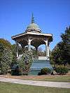 |
(#72000361) |
Central City Park 32°49′59″N 83°36′55″W / 32.833056°N 83.615278°W |
Macon | |
| 8 | Cherokee Brick and Tile Company |  |
(#02000338) |
3250 Waterville Rd. 32°46′01″N 83°37′24″W / 32.766944°N 83.623333°W |
Macon | |
| 9 | Cherokee Heights District | Upload image | (#82002385) |
Pio Nono, Napier, Inverness, and Suwanee Aves. 32°50′17″N 83°39′58″W / 32.838056°N 83.666111°W |
Macon | |
| 10 | Christ Episcopal Church | .JPG) |
(#71000250) |
538-566 Walnut St. 32°50′18″N 83°37′35″W / 32.838333°N 83.626389°W |
Macon | |
| 11 | Collins-Odom-Strickland House |  |
(#79000698) |
1495 2nd St. 32°49′25″N 83°38′23″W / 32.823611°N 83.639722°W |
Macon | |
| 12 | Cowles House |  |
(#71000251) |
988 Bond St. 32°50′32″N 83°38′04″W / 32.842222°N 83.634444°W |
Macon | |
| 13 | Jerry Cowles Cottage |  |
(#71000252) |
4569 Rivoli Dr. 32°52′26″N 83°42′17″W / 32.873889°N 83.704722°W |
Macon | |
| 14 | Dasher-Stevens House |  |
(#72000362) |
904 Orange Ter. 32°49′59″N 83°38′20″W / 32.833056°N 83.638889°W |
Macon | |
| 15 | Davis-Guttenberger-Rankin House |  |
(#73000609) |
134 Buford Pl. 32°50′47″N 83°39′35″W / 32.846389°N 83.659722°W |
Macon | |
| 16 | Domingos House |  |
(#71000253) |
1261 Jefferson Ter. 32°50′28″N 83°38′22″W / 32.841111°N 83.639444°W |
Macon | |
| 17 | East Macon Historic District | Upload image | (#93000281) |
Roughly bounded by Emery Hwy., Coliseum Dr., and Clinton, Fletcher and Fairview Sts. 32°50′42″N 83°36′43″W / 32.845°N 83.611944°W |
Macon | |
| 18 | Emerson-Holmes Building | .jpg) |
(#71000254) |
566 Mulberry St. 32°50′13″N 83°37′39″W / 32.836944°N 83.6275°W |
Macon | |
| 19 | Robert Findlay House | Upload image | (#72000363) |
785 2nd St. 32°49′54″N 83°38′01″W / 32.831667°N 83.633611°W |
Macon | Demolished |
| 20 | First Presbyterian Church |  |
(#72000364) |
690 Mulberry St. 32°50′17″N 83°37′47″W / 32.838056°N 83.629722°W |
Macon | |
| 21 | Fort Hawkins Archeological Site |  |
(#77000410) |
Address Restricted 32°50′56″N 83°36′42″W / 32.8489°N 83.6116°W |
Macon | |
| 22 | Fort Hill Historic District | Upload image | (#93000313) |
Roughly bounded by Emery Hwy., Second St. Ext., Mitchell and Morrow Sts. and Schaeffer Pl. 32°51′06″N 83°36′51″W / 32.851667°N 83.614167°W |
Macon | |
| 23 | Goodall House | Upload image | (#71000255) |
618 Orange St. 32°50′11″N 83°38′17″W / 32.836389°N 83.638056°W |
Macon | |
| 24 | Grand Opera House |  |
(#70000196) |
651 Mulberry St. 32°50′25″N 83°37′45″W / 32.840278°N 83.629167°W |
Macon | |
| 25 | Green-Poe House |  |
(#71000256) |
841-845 Poplar St. 32°50′15″N 83°38′01″W / 32.8375°N 83.633611°W |
Macon | |
| 26 | Hatcher-Groover-Schwartz House | 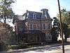 |
(#71000257) |
1144-1146 Georgia Ave. 32°50′25″N 83°38′15″W / 32.840278°N 83.6375°W |
Macon | |
| 27 | Walter R. Holt House | 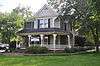 |
(#05000076) |
3776 Vineville Ave. 32°51′13″N 83°41′15″W / 32.853611°N 83.6875°W |
Macon | |
| 28 | Holt-Peeler-Snow House | 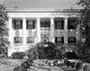 |
(#71000258) |
1129 Georgia Ave. 32°50′29″N 83°38′17″W / 32.841389°N 83.638056°W |
Macon | |
| 29 | Ingleside Historic District | 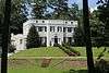 |
(#16000231) |
Roughly bounded by Vineville Ave, Candler Dr, Bonita Pl, High Point Rd, and Forest Hill Rd. 32°51′26″N 83°40′46″W / 32.857132°N 83.679464°W |
Macon | |
| 30 | Johnston-Hay House | .jpg) |
(#71000259) |
934 Georgia Ave. 32°50′25″N 83°38′01″W / 32.84034°N 83.63361°W |
Macon | National Historic Landmark |
| 31 | Sidney Lanier Cottage |  |
(#72000365) |
935 High St. 32°50′14″N 83°38′11″W / 32.837222°N 83.636389°W |
Macon | (see Sidney Lanier ) |
| 32 | Lassiter House | .jpg) |
(#72000366) |
315 College St. 32°50′32″N 83°38′17″W / 32.842222°N 83.638056°W |
Macon | Built in 1855, also known as the Bell House, now houses the Robert McDuffee Center for Strings, website |
| 33 | Ellamae Ellis League House | |
(#05000053) |
1790 Waverland Dr. 32°52′14″N 83°37′56″W / 32.870556°N 83.632222°W |
Macon | |
| 34 | Joseph and Mary Jane League House |  |
(#08001280) |
1849 Waverland Dr. 32°52′24″N 83°37′54″W / 32.8733°N 83.6318°W |
Macon | |
| 35 | W. G. Lee Alumni House | .JPG) |
(#71000260) |
1270 Ash (Coleman) St. 32°49′52″N 83°38′49″W / 32.831111°N 83.646944°W |
Macon | |
| 36 | William and Jane Levitt House |  |
(#15000996) |
3720 Overlook Dr. 32°51′54″N 83°41′01″W / 32.865072°N 83.683710°W |
Macon | |
| 37 | Lustron House at 3498 McKenzie Drive | Upload image | (#96000216) |
3498 McKenzie Dr. 32°50′52″N 83°40′57″W / 32.847778°N 83.6825°W |
Macon | |
| 38 | Macon Historic District | .jpg) |
(#74000658) |
Roughly bounded by Riverside Dr., Broadway, Elm, and I-75 32°50′11″N 83°38′11″W / 32.836389°N 83.636389°W |
Macon | This HD contains some of the other NRHP buildings |
| 39 | Macon Railroad Industrial District |  |
(#87000977) |
Roughly bounded by Fifth, Sixth, and Seventh Sts., Central of Georgia, Southern, and Seaboard RR tracks 32°49′31″N 83°37′33″W / 32.825278°N 83.625833°W |
Macon | |
| 40 | Macon Railway and Light Company Substation |  |
(#06000986) |
1015 Riverside Dr. 32°50′41″N 83°37′53″W / 32.844722°N 83.631389°W |
Macon | |
| 41 | DeWitt McCrary House |  |
(#74000659) |
320 Hydrolia St. 32°50′37″N 83°37′00″W / 32.843611°N 83.616667°W |
Macon | |
| 42 | Mechanics Engine House No. 4 |  |
(#90001434) |
950 Third St. 32°49′43″N 83°37′58″W / 32.828611°N 83.632778°W |
Macon | |
| 43 | Mercer University Administration Building |  |
(#71000261) |
Coleman Ave. 32°49′54″N 83°38′54″W / 32.831667°N 83.648333°W |
Macon | |
| 44 | A.L. Miller High School and A.L. Miller Junior High School |  |
(#14000928) |
2241 Montpelier Ave. 32°50′01″N 83°39′30″W / 32.8335579°N 83.658354°W |
Macon | |
| 45 | Militia Headquarters Building |  |
(#72000367) |
552-564 Mulberry St. 32°50′14″N 83°37′39″W / 32.837222°N 83.6275°W |
Macon | |
| 46 | Monroe Street Apartments | 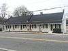 |
(#72000368) |
641-661 Monroe St. 32°50′18″N 83°38′37″W / 32.83847°N 83.64356°W |
Macon | |
| 47 | Municipal Auditorium | |
(#71000262) |
415-435 1st St. 32°50′14″N 83°37′53″W / 32.837222°N 83.631389°W |
Macon | |
| 48 | Munroe-Dunlap-Snow House | 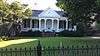 |
(#71000263) |
920 High St. 32°50′12″N 83°38′11″W / 32.836667°N 83.636389°W |
Macon | |
| 49 | Munroe-Goolsby House | 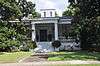 |
(#72000369) |
159 Rogers Ave. 32°50′50″N 83°39′18″W / 32.847222°N 83.655°W |
Macon | |
| 50 | Leroy Napier House | Upload image | (#71000264) |
2215 Napier Ave. 32°50′14″N 83°39′18″W / 32.83715°N 83.65506°W |
Macon | Apparently demolished |
| 51 | North Highlands Historic District | Upload image | (#93000297) |
Roughly bounded by Nottingham Dr., Boulevard and Clinton Rd. 32°51′19″N 83°37′25″W / 32.855278°N 83.623611°W |
Macon | |
| 52 | Ocmulgee National Monument | 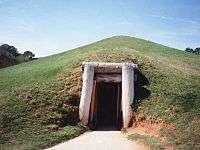 |
(#66000099) |
1207 Emory Hwy., E of Macon 32°49′46″N 83°36′07″W / 32.829444°N 83.601944°W |
Macon | administered by the National Park Service |
| 53 | Old Macon Library | 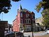 |
(#73000610) |
652-662 Mulberry St. 32°50′16″N 83°37′44″W / 32.837778°N 83.628889°W |
Macon | |
| 54 | Old U.S. Post Office and Federal Building | 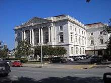 |
(#72000370) |
475 Mulberry St. 32°50′13″N 83°37′32″W / 32.836944°N 83.625556°W |
Macon | |
| 55 | Pleasant Hill Historic District | 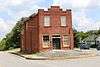 |
(#86001130) |
Roughly bounded by Sheridan Ave. and Schofield St., Madison, Jefferson and Ferguson, and Galliard Sts. 32°50′48″N 83°38′45″W / 32.846667°N 83.645833°W |
Macon | |
| 56 | Railroad Overpass at Ocmulgee | 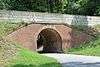 |
(#79000699) |
Off GA 49 32°50′29″N 83°35′59″W / 32.84141°N 83.59978°W |
Macon | In the Ocmulgee National Monument |
| 57 | Raines-Carmichael House | .jpg) |
(#71000265) |
1183 Georgia Ave. 32°50′29″N 83°38′16″W / 32.8413°N 83.63765°W |
Macon | National Historic Landmark |
| 58 | Randolph-Whittle House |  |
(#72000371) |
1231 Jefferson Ter. 32°50′27″N 83°38′18″W / 32.840833°N 83.638333°W |
Macon | |
| 59 | Riverside Cemetery | 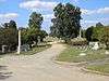 |
(#83000183) |
1301 Riverside Dr. 32°51′04″N 83°38′18″W / 32.851111°N 83.638333°W |
Macon | |
| 60 | Rock Rogers House | 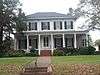 |
(#72000372) |
331 College St. 32°50′33″N 83°38′17″W / 32.8426°N 83.63803°W |
Macon | |
| 61 | Rose Hill Cemetery | 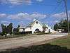 |
(#73000611) |
Riverside Dr. 32°50′52″N 83°38′01″W / 32.847778°N 83.633611°W |
Macon | |
| 62 | Shirley Hills Historic District |  |
(#89001093) |
Roughly Senate Pl., Parkview Dr., Curry Dr., Briarcliff Rd., Nottingham Dr., and the Ocmulgee River; also roughly bounded by Boulevard Ave., Woodland Dr., Waveland Cir., Nottingham, Briarcliff & Upper River Rds. 32°51′33″N 83°37′50″W / 32.859167°N 83.630556°W |
Macon | Boundary increase on May 28, 2014 (#14000269)[4] |
| 63 | Slate House | 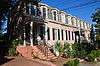 |
(#74000660) |
931-945 Walnut St. 32°50′32″N 83°37′54″W / 32.842222°N 83.631667°W |
Macon | |
| 64 | Small House | 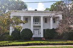 |
(#71000266) |
156 Rogers Ave. 32°50′50″N 83°39′21″W / 32.847222°N 83.655833°W |
Macon | |
| 65 | Solomon-Curd House | Upload image | (#71000267) |
770 Mulberry St. 32°50′19″N 83°37′49″W / 32.838611°N 83.630278°W |
Macon | |
| 66 | Solomon-Smith-Martin House | 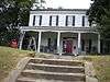 |
(#71000268) |
2619 Vineville Ave. 32°50′47″N 83°39′46″W / 32.846389°N 83.662778°W |
Macon | |
| 67 | St. Joseph's Catholic Church | 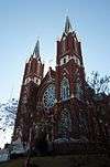 |
(#71000269) |
812 Poplar St. 32°50′12″N 83°38′01″W / 32.836667°N 83.633611°W |
Macon | |
| 68 | Tindall Heights Historic District | Upload image | (#93000587) |
Roughly bounded by Broadway, Eisenhower Pkwy., Felton and Nussbaum Aves., Central of Georgia RR tracks and Oglethorpe St 32°49′24″N 83°38′36″W / 32.823333°N 83.643333°W |
Macon | |
| 69 | Villa Albicini | 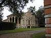 |
(#74000661) |
150 Tucker Rd. 32°52′25″N 83°42′41″W / 32.873611°N 83.711389°W |
Macon | |
| 70 | Vineville Historic District | Upload image | (#80000974) |
GA 247 and U.S. 41 32°50′46″N 83°39′33″W / 32.846111°N 83.659167°W |
Macon | |
| 71 | Wesleyan College Historic District | 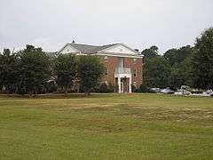 |
(#04000242) |
4760 Forsyth Rd. 32°52′20″N 83°43′08″W / 32.872222°N 83.718889°W |
Macon | a historic district at Wesleyan College |
| 72 | Luther Williams Field |  |
(#04000627) |
225 Willie Smokey Glover Blvd., Central City Park 32°49′44″N 83°36′51″W / 32.828889°N 83.614167°W |
Macon | |
| 73 | Willingham-Hill-O'Neal Cottage | 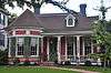 |
(#71000270) |
535 College St. 32°50′19″N 83°38′22″W / 32.838611°N 83.639444°W |
Macon |
See also
| Wikimedia Commons has media related to National Register of Historic Places in Bibb County, Georgia. |
- List of National Historic Landmarks in Georgia (U.S. state)
- National Register of Historic Places listings in Georgia
References
- ↑ "National Register of Historic Places: Weekly List Actions". National Park Service, United States Department of the Interior. Retrieved on December 16, 2016.
- ↑ Numbers represent an ordering by significant words. Various colorings, defined here, differentiate National Historic Landmarks and historic districts from other NRHP buildings, structures, sites or objects.
- ↑ The eight-digit number below each date is the number assigned to each location in the National Register Information System database, which can be viewed by clicking the number.
- ↑ Shirley Hills Historic District boundary increase nomination form
This article is issued from Wikipedia - version of the 10/11/2016. The text is available under the Creative Commons Attribution/Share Alike but additional terms may apply for the media files.