Nathalie, Virginia
| Nathalie, Virginia | |
|---|---|
| Census-designated place (CDP) | |
 Location of Nathalie, Virginia: the red dot | |
| Coordinates: 36°56′06″N 78°56′50″W / 36.93500°N 78.94722°WCoordinates: 36°56′06″N 78°56′50″W / 36.93500°N 78.94722°W | |
| Country | United States |
| State | Virginia |
| County | Halifax |
| Elevation | 169 ft (554 m) |
| Population (2010) | |
| • Total | 183 |
| Time zone | Eastern (EST) (UTC-5) |
| • Summer (DST) | EDT (UTC-4) |
| ZIP code | 24577 |
| Area code(s) | 434 |
Nathalie is a census-designated place (CDP) in Halifax County, Virginia, United States, in the south central region of the state.[1] The population as of the 2010 Census was 183.[2] Located at 36°56′6″N 78°56′50″W / 36.93500°N 78.94722°W (36.9348619, -78.9472347), at an altitude of 554 feet (169 m),[3] it lies along Road 603 north of the town of Halifax, the county seat of Halifax County.[1] It received its name in 1890 or 1891, being named after Natalie Otey (not Nathalie), daughter of Mrs. Rebecca Wimbish, an important local landowner.[4] Prior to that time, the village at this location was considered to be a part of the Nathaniel Barksdale plantation. It had included a church since 1773 (the first Catawba Baptist Church) and a post office since 1828.[5] This post office continues to operate today with the ZIP code of 24577.[6] The population of the ZCTA for ZIP code 24577 was 5,529 at the 2000 census.[7]
The Clarkton Bridge was listed on the National Register of Historic Places in 2006.[8]
References
- 1 2 Rand McNally. The Road Atlas '09. Chicago: Rand McNally, 2009, p. 106.
- ↑ Virginia Trend Report 2: State and Complete Places (Sub-state 2010 Census Data). Missouri Census Data Center. Accessed 2011-06-08.
- ↑ U.S. Geological Survey Geographic Names Information System: Nathalie, Virginia
- ↑ Nathalie - Largest Rural Mail Route in the U.S. from 1974 article in the Gazette-Virginian by Hugh D. Koontz, II.
- ↑ History of Nathalie, Virginia, based on information from History of Halifax (2 vols.), 1978, by Pocahontas Edmunds, ASIN: B0007AN8NO
- ↑ Zip Code Lookup
- ↑ "American FactFinder". United States Census Bureau. Retrieved 2008-01-31.
- ↑ National Park Service (2010-07-09). "National Register Information System". National Register of Historic Places. National Park Service.
Municipalities and communities of Halifax County, Virginia, United States | ||
|---|---|---|
| Towns | 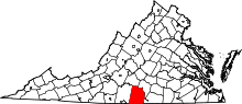 | |
| CDPs | ||
| Unincorporated communities | ||
| Footnotes | ‡This populated place also has portions in an adjacent county or counties | |