Nannup, Western Australia
| Nannup Western Australia | |||||||
|---|---|---|---|---|---|---|---|
 | |||||||
| Coordinates | 33°58′55″S 115°45′54″E / 33.982°S 115.765°ECoordinates: 33°58′55″S 115°45′54″E / 33.982°S 115.765°E | ||||||
| Population | 501 (2011 census)[1] | ||||||
| Established | 1889 | ||||||
| Postcode(s) | 6275 | ||||||
| Elevation | 130 m (427 ft) | ||||||
| Location |
| ||||||
| LGA(s) | Shire of Nannup | ||||||
| State electorate(s) | Blackwood-Stirling | ||||||
| Federal Division(s) | Forrest | ||||||
| |||||||
Nannup is a town and shire in the South West region of Western Australia, approximately 280 kilometres (174 mi) south of Perth on the Blackwood River at the crossroads of Vasse Highway and Brockman Highway, linking Nannup to most of the Lower South West's regional centres. At the 2011 census, Nannup had a population of 501.[1]
History
Nannup's name is of Noongar Aboriginal origin, meaning either "stopping place" or "place of parrots", and was first recorded by surveyors in the 1860s. The area was initially known as "Lower Blackwood", and was first explored by Thomas Turner in 1834. In 1866, a bridge was built over the river and a police station was established. A townsite was set aside in 1885, surveyed in 1889 and gazetted on 9 January 1890.[2] In 1906, a primary school and shire office were built.
In 1909, the Nannup Branch Railway (no longer in operation) was extended from Jarrahwood, linking to the Bunbury-Busselton railway.
Menaced by bushfires in 1928, settlers had to battle hard against the flames in order to save their properties.[3] More bushfires, fanned by strong winds, swept across the region in 1935 burning out over 100 hectares (247 acres) and destroying one house and a barn.[4] More bushfires were burning in the district over the course of several days in 1937 resulting in the stables and the sheds at the local race course to be burned down, the destruction of large amounts of feed for stock and the loss of telephone lines.[5]
The town was flooded in 1945 when the Blackwood River rose to its highest flood level recorded to that date. Three families were left homeless and others had to be evacuated from the floodwaters.[6] At its highest level the river was running 3.5 feet (1.1 m) over the Russell Street bridge and the town's electricity supply failed from lines being damaged, leaving the town in darkness.[7] The river flooded again in 1946 and 1947 closing roads but not causing any significant damage to the town.[8]
In 1949 the town received 6.86 inches (174 mm) of rain in a period of seven hours, causing flooding and one bridge connecting the town to Busselton to be swept away.[9]
Bushfires once again struck in 1950 with several large fires burning only a few miles from town. The outbreak destroyed nearly 30,000 acres (12,141 ha) of Jarrah and Karri forest. The fires were brought under control reasonably quickly and were believed to have been deliberately lit.[10]
The Dry Brook bridge just outside town on the Nannup-Balingup collapsed as a result of flood damage from the previous years. Although the bridge had been repaired after being damaged in smaller floods of 1950, it was undercut again and caved in without causing any injuries.[11]
In 1982 after the remnants of a Tropical cyclone passed through the south west, the town and surrounding areas were inundated by heavy rains. The Blackwood rose 11.6 metres (38 ft) submerging over 50 houses.[12]
Many historical photographs are held by the Nannup Historical Society and details are available at http://www.nannuphistory.org
The movie Drift was filmed largely in Nannup.
Marinko Tomas memorial
Marinko Tomas (1945–1966), a farmer, originally from Nannup, was Western Australia's first national serviceman killed in the Vietnam War. A memorial with a statue and plaque was erected in March 1988 in Nannup's Bicentennial Park. Lance Corporal Tomas died on 8 July 1966, at the age of 21 years, after being hit by shrapnel from "friendly artillery forces".[13][14][15]
Present day
Nannup is the only town within the Shire of Nannup, and has a district high school (1961), telecentre, shire offices, roadhouse, a sporting complex, shopping facilities, accommodation for travellers (hotel/motel, B&Bs, caravan park), police station, three cafes, a hardware store, community centre, golf club and golf course, nursery and a gemstone museum. The main street has changed little over the years so has considerable heritage value.
The town population is about 600, with 1200 in the Shire of Nannup.
Economy
Timber milling and agriculture (principally beef cattle) dominate the local economy although wine, floriculture and tourism are industries of growing importance. Furniture production and other local timber value-adding activities are also a minor employer.
Events and festivals
Since the beginnings of the tourist industry in Nannup there have been several events and festivals held to promote the town. These include the week-long Flower and Garden Festival held in August each year and the weekend Rose Festival in November. The largest of Nannup's annual festivals is the Nannup Music Festival (formerly the Southwest Folk Festival) held over the Labour Day long weekend in March each year and includes street performance and market stalls as well as a variety of musical performances.
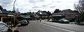 Panorama of main street in June 2007
 Panorama of main street in June 2007
See also
References
- 1 2 Australian Bureau of Statistics (31 October 2012). "Nannup (L) (Urban Centre/Locality)". 2011 Census QuickStats. Retrieved 9 April 2014.
- ↑ Western Australian Land Information Authority. "History of country town names – N". Retrieved 2007-04-17.
- ↑ "Country news". The West Australian. Perth: National Library of Australia. 13 March 1928. p. 4. Retrieved 9 April 2013.
- ↑ "Country Fires". The West Australian. Perth: National Library of Australia. 28 February 1935. p. 15. Retrieved 9 April 2013.
- ↑ "South-west bushfires". The West Australian. Perth: National Library of Australia. 2 April 1937. p. 16. Retrieved 9 April 2013.
- ↑ "Nannup Floods Rise Again.". The Daily News. Perth: National Library of Australia. 29 June 1945. p. 15. Retrieved 8 April 2013.
- ↑ "Nannup Flood". The West Australian. Perth: National Library of Australia. 2 July 1945. p. 4. Retrieved 8 April 2013.
- ↑ "Floods at Nannup.". Kalgoorlie Miner. Western Australia: National Library of Australia. 23 June 1947. p. 4. Retrieved 8 April 2013.
- ↑ "Heavy Rainfall Floods W.A. Town.". The Mercury. Hobart, Tasmania: National Library of Australia. 28 April 1949. p. 20. Retrieved 9 April 2013.
- ↑ "Incendiarism near Nannup feared". The West Australian. Perth: National Library of Australia. 14 February 1950. p. 1. Retrieved 9 April 2013.
- ↑ "Road Bridge Collapses Near Nannup.". The West Australian. Perth: National Library of Australia. 30 July 1952. p. 11. Retrieved 8 April 2013.
- ↑ "Floods bring havoc to the south west.". The Australian Women's Weekly. Sydney: National Library of Australia. 17 February 1982. p. 4. Retrieved 8 April 2013.
- ↑ "Marinko Tomas". National Library of Australia. 1988-03-05. Retrieved 26 February 2013.
Commemorates the first West Australian national serviceman to be killed in Vietnam. Marinko ('Tich') Tomas was a 21-year-old farmer from Manning in Western Australia. Tomas was called up on 30 June 1965, and was a Lance Corporal with the 5th Battalion of the Royal Australian Regiment (5 RAR). He had been in Vietnam less than a month when he was killed in July 1966 as a result of shrapnel wounds to the back from friendly artillery forces
. - ↑ "Memorial to Marinko Tomas in Nannup, Western Australia". Vietnam Veterans Association of Australia (VVAA). Retrieved 26 February 2013.
- ↑ "Lance Corporal Marinko 'Tich' Tomas". 5th Battalion, Royal Australian Regiment. Archived from the original on 14 March 2009. Retrieved 26 February 2013.
External links
| Wikimedia Commons has media related to Nannup, Western Australia. |