New York State Route 315
| ||||
|---|---|---|---|---|
|
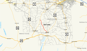
Map of Oneida County in central New York with NY 315 highlighted in red | ||||
| Route information | ||||
| Maintained by NYSDOT | ||||
| Length: | 5.27 mi[1] (8.48 km) | |||
| Existed: | 1930[2] – present | |||
| Major junctions | ||||
| South end: |
| |||
| North end: |
| |||
| Location | ||||
| Counties: | Oneida | |||
| Highway system | ||||
| ||||

New York State Route 315 (NY 315) is a state highway in Oneida County, New York, in the United States. It begins at an intersection with NY 12 in the village of Waterville and ends at a junction NY 12B in the hamlet of Deansboro, located in the town of Marshall. NY 315 was assigned as part of the 1930 renumbering of state highways in New York.
Route description
At the southern end, NY 315 begins in Waterville at an intersection with NY 12. Paralleling Big Creek, the route heads northwestward through mostly rural and residential land. The route, locally known as Buell Avenue along this stretch of its source, crosses several of the creek's tributaries as it progresses towards the hamlet of Deansboro, where it bends slightly westward and uneventfully terminates at NY 12B.[3] Approximately midway between Waterville and Deansboro is Forge Hollow. Here, the road makes an S-shaped turn around Big Creek and one finds a rock face with caves and a natural spring. The entire route is five miles long.
History

NY 315 was assigned to its current alignment during the 1930 state highway renumbering.[2] Since then, it has not undergone any major alterations.
Major intersections
The entire route is in Oneida County.
| Location | mi[1] | km | Destinations | Notes | |
|---|---|---|---|---|---|
| Waterville | 0.00 | 0.00 | |||
| Marshall | 5.27 | 8.48 | Hamlet of Deansboro | ||
| 1.000 mi = 1.609 km; 1.000 km = 0.621 mi | |||||
See also
.svg.png) New York Roads portal
New York Roads portal
References
- 1 2 "2008 Traffic Volume Report for New York State" (PDF). New York State Department of Transportation. June 16, 2009. p. 212. Retrieved February 1, 2010.
- 1 2 Road Map of New York (Map). Cartography by General Drafting. Standard Oil Company of New York. 1930.
- ↑ Google (December 23, 2009). "New York State Route 315" (Map). Google Maps. Google. Retrieved December 23, 2009.
External links
| Wikimedia Commons has media related to New York State Route 315. |
- New York State Route 315 at New York Routes • New York State Highway Termini