Nörten-Hardenberg
| Nörten-Hardenberg | ||
|---|---|---|
| ||
 Nörten-Hardenberg | ||
Location of Nörten-Hardenberg within Northeim district 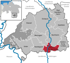
 | ||
| Coordinates: 51°37′N 9°56′E / 51.617°N 9.933°ECoordinates: 51°37′N 9°56′E / 51.617°N 9.933°E | ||
| Country | Germany | |
| State | Lower Saxony | |
| District | Northeim | |
| Government | ||
| • Mayor | Astrid Klinkert-Kittel (Ind.) | |
| Area | ||
| • Total | 54.08 km2 (20.88 sq mi) | |
| Population (2015-12-31)[1] | ||
| • Total | 8,109 | |
| • Density | 150/km2 (390/sq mi) | |
| Time zone | CET/CEST (UTC+1/+2) | |
| Postal codes | 37176 | |
| Dialling codes | 05503 | |
| Vehicle registration | NOM | |
| Website | www.noerten-hardenberg.de | |

Nörten-Hardenberg (Eastphalian: Nörten-Harenbarg) is a municipality in the district of Northeim, in Lower Saxony, Germany.
Geography
It is situated on the river Leine, approx. 10 km southwest of Northeim, and 10 km north of Göttingen. The main town is located on the foothills of the Nörtener Wald but great parts of the municipality are in the Leinegraben, a lowland between the Solling and the Harz.
Neighbor communities are Bovenden (south), Hardegsen (west), Moringen (northwest), Katlenburg-Lindau (east) and Northeim (north)
Besides the main town himself, the following villages are component localities of Nörten-Hardenberg:
|
|
References
See also: Hardenberg (surname) and Hardenberg (disambiguation)
Towns and municipalities in Northeim (district) | ||
|---|---|---|
This article is issued from Wikipedia - version of the 12/1/2016. The text is available under the Creative Commons Attribution/Share Alike but additional terms may apply for the media files.