Žetale
| Žetale Občina Žetale | |
|---|---|
| Town and Municipality | |
|
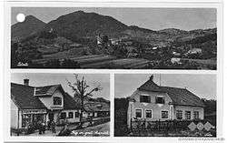
Postcard of Žetale | |
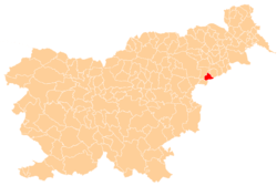 Location of the Municipality of Žetale in Slovenia | |
 Žetale Location of the Town of Žetale in Slovenia | |
| Coordinates: 46°16′N 15°48′E / 46.267°N 15.800°ECoordinates: 46°16′N 15°48′E / 46.267°N 15.800°E | |
| Country |
|
| Government | |
| • Mayor | Anton Butolen |
| Area | |
| • Total | 38.0 km2 (14.7 sq mi) |
| Population (2002)[1] | |
| • Total | 1,364 |
| • Density | 36/km2 (93/sq mi) |
| Time zone | CET (UTC+01) |
| • Summer (DST) | CEST (UTC+02) |
Žetale (pronounced [ʒɛˈtaːlɛ]) is a village and a municipality in eastern Slovenia, on the border with Croatia. The area traditionally belonged to the region of Styria. It is now included in the Drava Statistical Region.[2]
History
The village of Čermožiše has evidence of a settlement from the neolithic era. Žetale was first mentioned in written documents dating to 1228, and old parish documents record its name as Schiltarin. The area was subject to repeated Ottoman invasion, and thus pseudoetymological claims that the village is named after a supposed defender of the village named Žetal. In fact, the name is derived from Middle High German Schiltern.[3] As of 2002, the village of Žetale had a population of 390.[4]
Festivals
A chestnut festival in October is a locally well known. There is an annual pilgrimage called Jarmek held on 15 August, the feast day of the Assumption of Mary and a public holiday in Slovenia, where pilgrims walk to Mary Help of Christians Church (Slovene: Marija pomočnica), known locally as Marijatrošt.
Flag and Coat of Arms
The flag and coat of arms of Žetale are a principally green and yellow design, featuring sweet chestnut leaves and fruit. Above it on the coat of arms is a castle embattlement upon which stands the flaming sword and scales of the Archangel Michael.[5]
Municipality
The municipality of Žetale covers a total area of 12.66 km2 (4.89 sq mi) in the Drava Statistical Region. It consists of the villages of Žetale, Čermožiše, Dobrina, Kočice, and Nadole, with a total population of 1,364[6]
Nearby attractions
The Jože of Žetale Hiking Trail hiking trail (Slovene: Pot Jožeta Žetalskega) with a precipice on the north side leads from Žetale to Donačka Gora, passing Resenik Hill and Medgorje to the eastern third peak. The views available include the forested slopes of Mount Macelj (Slovene: Maceljska gora), Resenik Hill, Žetale, the vineyards of Haloze, and the church of Mary Help of Christians (Slovene: Marija pomočnica).
Churches
The Žetale Valley has a number of churches. Saint Sebastian's Church (Slovene: Sv. Boštjan), dating to 1415 was built in memory of victims of the plague. Nearby is the pilgrimage Church of Mary Help of Christians (Slovene: Marija pomočnica) from 1725. Archangel Michael's Church from 1426 stands in the settlement. At Mohor is Saints Hermagoras and Fortunatus Church (Slovene: Sv. Mohor in Fortunat) from the 15th century. After 1507 it became a place of pilgrimage.
People
- Anton Hajšek (1827–1907): patriot and publisher of the writings of Anton Martin Slomšek
- Jože Topolovec (1934–2010): writer (pseudonym Jože Haložan)
References
- ↑ Statistical Office of the Republic of Slovenia, census of 2002
- ↑ Žetale municipal site
- ↑ Snoj, Marko. 2009. Etimološki slovar slovenskih zemljepisnih imen. Ljubljana: Modrijan and Založba ZRC, p. 489.
- ↑ Statistical Office of the Republic of Slovenia
- ↑ Flags of the World site
- ↑ .Statistical Office of the Republic of Slovenia
External links
| Wikimedia Commons has media related to Žetale. |
| Settlements | Administrative centre: Žetale
| | ||||||
|---|---|---|---|---|---|---|---|---|
| Landmarks |
| |||||||