Mullach Fraoch-choire
| Mullach Fraoch-choire | |
|---|---|
|
Mullach Fraoch-choire from its northwest ridge | |
| Highest point | |
| Elevation | 1,102 m (3,615 ft) [1] |
| Prominence | 153 m (502 ft) [2] |
| Parent peak | A' Chràlaig[2] |
| Listing | Munro, Marilyn |
| Coordinates | 57°12′19″N 05°09′20″W / 57.20528°N 5.15556°WCoordinates: 57°12′19″N 05°09′20″W / 57.20528°N 5.15556°W |
| Naming | |
| Translation | heather-corrie peak[3] (Gaelic) |
| Geography | |
| Parent range | Northwest Highlands |
| OS grid | NH094171 |
| Topo map |
OS Landranger 33 / 34[4] Explorer 415 |
.jpg)

Mullach Fraoch-choire is a 1,102-metre (3,615 ft) mountain – a Munro – in the Northwest Highlands of Scotland on a ridge extending north for 8 kilometres (5.0 mi) between Loch Cluanie in Glenmoriston and upper Glen Affric.[1] It is within the Glen Affric National Scenic Area and Glen Affric National Nature Reserve.[5][6]
Geographical situation
Mullach Fraoch-choire is located south of upper Glen Affric and north of Loch Cluanie at the head of Glenmoriston as the valley continues west to become Glen Shiel and Kintail. The mountain is one of the four Munros on the "Cluanie Horseshoe",[note 1] a crescent of high peaks which also includes nine Munro Tops. It lies on the western arm of the horseshoe which loops around Gleann na Ciche whose burns flow north to the River Affric.[8] West of the horseshoe is a deep glen connecting Cluanie and Affric – south of its watershed is An Caorran Mor with its stream flowing south to Loch Cluanie while to the north Allt a' Chomhlain flows north to the River Affric.[1] Mullach Fraoch-choire has a subsidiary Top on its northeast ridge at 1,047 metres (3,435 ft).[8] Somewhat beyond the lowest col on its south ridge is Stob Coire na Chràlaig at 1,008 metres (3,307 ft) which is regarded as a subsidiary peak of A' Chràlaig although it is more distant from the latter peak.[1][9]
Walking routes
From the north the mountain may be climbed from the very remote Glen Affric Youth Hostel at Alltbeithe or, from the south, from near Cluanie Inn on the A87 beside Loch Cluanie.[1] The horseshoe is most conveniently traversed starting from Glen Affric but the nearest public road to the youth hostel is, in fact, by Loch Cluanie.[8][1]
From Cluanie a frequently-used route climbs A' Chràlaig first and then traverses the ridge north from there. This involves something of a scramble around several pinnacles with steep drops on both sides – to Coire na Geurdain on the east and Coire Odhar on the west. The last half-kilometre of the ridge before reaching Mullach Fraoch-Choire is spectacularly narrow and in winter it becomes a Scottish Grade I climb.[10][11][12] A return may be made by using the outward route or by descending Coire Odhar from the col near Stob Coire na Chràlaig.[3]


-
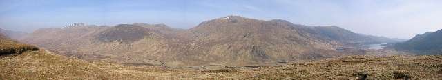
View north to upper Glen Affric from Mullach Fraoch-choire northeast ridge with Sgurr nan Ceathreamhnan to the left and Loch Affric to the right
Notes
- ↑ The other three Munros are A' Chràlaig, Sgurr nan Conbhairean and Sail Chaorainn.[7]
References
Citations
- 1 2 3 4 5 6 Bennet (1990), p. 133.
- 1 2 "Mullach Fraoch-choire - Peakbagger.com". www.peakbagger.com. Archived from the original on 30 April 2016.
- 1 2 Bennet (1991), p. 173.
- ↑ Bailey (2011), p. 167.
- ↑ "Glen Affric National Scenic Area". Scottish Natural Heritage. Scottish Natural Heritage. Archived from the original (PDF) on 30 April 2016.
- ↑ "Glen Affric - Forestry Commission Scotland". scotland.forestry.gov.uk. Forrestry Commission Scotland. Retrieved 1 May 2016. and
"The Forest Walks of Glen Affric National Nature Reserve" (PDF). scotland.forestry.gov.uk. Forestry Commission Scotland. Retrieved 1 May 2016. (see the main map) - ↑ Bennet (1991), pp. 172–173.
- 1 2 3 Butterfield (1986), pp. 190–192.
- ↑ Butterfield (1986), pp. 190.
- ↑ Butterfield (1986), pp. 191.
- ↑ Bailey (2014), p. 107.
- ↑ Dyer, Anthony. "The mountains of Glen Shiel, North West Highlands - an illustrated guide. North Glen Shiel: Cluanie Horseshoe". www.mountainhiking.org.uk. Archived from the original on 30 April 2016.
Works cited
- Bailey, Dan (2011). "The North and West Highlands, Route 32 South Ridge Mullach Fraoch-Coire". Scotland's Mountain Ridges: Scrambling, Mountaineering and Climbing - the best routes for summer and winter. Cicerone Press. pp. 167–170. ISBN 9781849654340. Retrieved 30 April 2016.
- Bailey, Dan (2014). "Northwest Highlands Walk 17: Cluanie Horseshoe from Glen Affric". Great Mountain Days in Scotland: 50 classic hillwalking challenges. Cicerone Press. pp. 105–108. ISBN 9781849655002.
- Bennet, Donald (1990). "Chapter 8: Strath Cluanie and Glen Affric". In Bennet, Donald; Strang, Tom. The Northwest Highlands. Scottish Mountaineering Trust. pp. 127–143. ISBN 0-907521-28-2.
- Bennet, Donald (1991). "Section 11: Glen Affric and Kintail". In Bennet, Donald. The Munros (2nd ed.). Scottish Mountaineering Trust. pp. 164–179. ISBN 0-907521-31-2.
- Butterfield, Irvine (1986). "Chapter 20: North Glen Sheil and Glen Cluanie". The High Mountains of Britain and Ireland (Book Club Associates ed.). Diadem Books. pp. 183–192.
 |
|  | |