Northwest Highlands
Coordinates: 57°30′N 5°0′W / 57.500°N 5.000°W The Northwest Highlands are located in the northern third of Scotland that is separated from the Grampian Mountains by the Great Glen (Glen More). The region comprises Wester Ross, Assynt, Sutherland and part of Caithness. The Caledonian Canal, which extends from Loch Linnhe in the south-west, via Loch Ness to the Moray Firth in the north-east splits this area from the rest of the country. The city of Inverness and the town of Fort William, by far the two largest settlements in the area, are both close to the boundary between the Northwest Highlands and the Grampian Mountains.
Geology
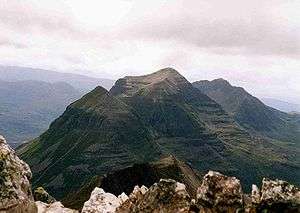
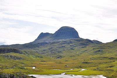
The Highlands are formed on Lewisian gneiss, the oldest layers of rock in Scotland. Liathach, Beinn Alligin, Suilven, Cùl Mòr, Cùl Beag, and Quinag are just some of the impressive rock islands of dark red Torridonian sandstone which rests on the gneiss, being the younger rock. Some of the peaks, such as Beinn Eighe and Canisp, are topped with later light grey or white Cambrian quartzite. The gneiss, sandstones and quartzite are among the oldest rocks in the world.
The city of Inverness, known as the "Capital of the Highlands", is by far the largest settlement in the region. It is the administrative centre for the Highland Council area.


Climate
This area's climate is dominated by the warming influence of the Gulf Stream but varies with altitude. It has warm, wet summers on average under 17C (62.6F). The winters are mild at low altitude but become snowier and colder with higher elevation; naturally, the area would be a vast birch, pine and montane shrub forest, such as those surviving in Glen Affric. Snow may lie from more than a month to 105 days, but not at coastal or very low altitudes.
Geography
The region has steep, glacier-carved mountains, glens and interspersed plains. Many islands (which also vary widely in geography) lie off the coast. Elevations of around 2500 feet (750 m) or over are common, as are mountains exceeding 3000 feet or 914 m (Munros). In comparison, across the Great Glen to the south of the region the Nevis range reaches over 1300 metres and includes the highest point in all of Britain; while to the east are the Cairngorms with summits above 1200 metres and a plateau which is the coldest place in Britain. The Northwest Highlands are typically not quite as cold as the Cairngorms. Considering its terrain and its latitude of about 57 to 58 degrees North, the area is surprisingly warm: this is due to the mild influence of the Gulf Stream. The aurora borealis is sometimes visible on winter nights, especially at the climax of the 11-year cycle.
Bordering the region to the north east is the lowland area of Caithness. There are relatively few roads, and many are single lane (with passing places).
The region has a very low population density. Significant settlements are Kyle of Lochalsh, Mallaig, Dingwall, Dornoch, and Ullapool.
List of places in the Northwest Highlands
Towns and villages
Regions and mountain ranges
- Achnashellach Forest
- Applecross
- Assynt
- Coigach
- Dundonnell and Fisherfield Forest
- Inverpolly
- Kintail
- Knoydart
- Skye
- Torridon Hills
Glens and lochs
- Glen Kingie
- Glen Affric
- Glen Shiel
- Loch Cluanie
- Loch Torridon
- Loch Maree
- Loch Ness