Mount Pritchard
| Mount Pritchard Sydney, New South Wales | |||||||||||||
|---|---|---|---|---|---|---|---|---|---|---|---|---|---|
 Mounties Club | |||||||||||||
| Coordinates | 33°53′53″S 150°54′04″E / 33.898°S 150.901°ECoordinates: 33°53′53″S 150°54′04″E / 33.898°S 150.901°E | ||||||||||||
| Population | 9,044 (2011 census)[1] | ||||||||||||
| Established | 1896 | ||||||||||||
| Postcode(s) | 2170 | ||||||||||||
| Location | 34 km (21 mi) south-west of Sydney CBD | ||||||||||||
| LGA(s) | City of Fairfield | ||||||||||||
| State electorate(s) | Cabramatta | ||||||||||||
| Federal Division(s) | |||||||||||||
| |||||||||||||
Mount Pritchard is a suburb of Sydney, in the state of New South Wales, Australia 34 kilometres south-west of the Sydney central business district, in the local government area of the City of Fairfield and is part of the South-western Sydney region.
History
Mount Pritchard was originally home to the Cabrogal people who occupied much of the greater Fairfield area. In the early 19th century, the land was granted to a number of ex-convicts for farming. Later it was made part of the Male Orphan School Estate. In 1913, land west of Cabramatta Creek and Orange Grove Road previously owned by the Bull family was subdivided into smaller residential lots by a real estate property salesman named Hugh Pritchard, who named it the Cabramatta Park Estate.[2] From 1919, to honour Mr Pritchard's releasing from debt a number of landowners whom he'd financed, the estate was renamed Mount Pritchard.[3][4] The local electoral polling place followed suit in 1924.[5] From the early settler days the general area had been known unofficially as Mount Misery, originally because of a story of one of the early settlers and his family camping there whilst travelling, losing their bullocks, and for three weeks remaining in misery until starvation compelled them to beat a retreat, minus bullocks and dray.[6]
Demographics
At the 2006 Australian census, Mount Pritchard had a population of 8895 which was fairly multicultural. Nine percent of the population was born in Vietnam and 12% spoke Vietnamese at home. There were also a substantial number of speakers of Arabic (7.1%), Italian (5.1%) and Serbian (4.8%). The large number of Vietnamese made Buddhism the second most popular religion (12.8%) behind only Catholicism (32%). The median household income of $798 per week was well below the national average of $1027 while the average mortgage repayment of $1500 per month was above the national average of $1300 placing the suburb firmly in mortgage belt territory.[7]
Transport
Westbus has one bus route servicing Mount Pritchard which is the 808 from Fairfield to Liverpool. Metrolink, on the other hand, has two bus routes servicing Mount Pritchard. The 816 from Greenfield Park (via Meadows Road, Mount Pritchard) to Cabramatta and the 815 from Mount Pritchard to Cabramatta.[8] The closest train stations are the Cabramatta, Liverpool and Warwick Farm station.
Education
Mount Pritchard has two government primary schools: Mount Pritchard Public[9] and Mount Pritchard East Public School.[10] There is also the Les Powell School[11] for students with severe intellectual and multiple disabilities.
Sport and recreation
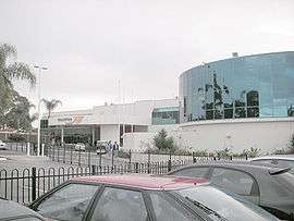
The Mounties Club in Meadows Road, Mount Pritchard supports a number of local teams in various sports, including the Mounties rugby league team in the NSW Cup and the Mounties Wanderers in the National Premier Leagues NSW 2.[12]
Mount Pritchard also has an oval, Mount Pritchard Oval, for the rugby league and football team.
References
- ↑ Australian Bureau of Statistics (31 October 2012). "Mount Pritchard (State Suburb)". 2011 Census QuickStats. Retrieved 18 April 2015.
- ↑ "Houses and Land For Sale". The Sydney Morning Herald. Retrieved 2013-02-25.
- ↑ "Peace Offering". The Sydney Morning Herald. Retrieved 2013-02-25.
- ↑ "Mount Pritchard". 'The Biz' Newspaper, Fairfield. Retrieved 2013-02-25.
- ↑ "Names Changed". Windsor and Richmond Gazette. Retrieved 2013-02-25.
- ↑ "Towns And Villages of New South Wales". 'The Australian Town and Country Journal', Sydney. Retrieved 2013-02-25.
- ↑ Australian Bureau of Statistics (25 October 2007). "Mount Pritchard (State Suburb)". 2006 Census QuickStats. Retrieved 2008-07-01.
- ↑ "Metro-Link timetables".
- ↑ "Mount Pritchard Public School". NSW Department of Education. Retrieved 2008-07-07.
- ↑ "Mount Pritchard East Public". NSW Department of Education. Retrieved 2008-07-07.
- ↑ "Les Powell School". NSW Department of Education. Retrieved 2008-07-07.
- ↑ "Sports & sub clubs". Mounties. Retrieved 2008-07-01.
| Wikimedia Commons has media related to Mount Pritchard, New South Wales. |