Mount Pilchuck
| Mount Pilchuck | |
|---|---|
 Mount Pilchuck in winter | |
| Highest point | |
| Elevation | 5,344 ft (1,629 m) NAVD 88[1] |
| Prominence | 2,860 ft (870 m) [1] |
| Coordinates | 48°03′29″N 121°47′52″W / 48.057960661°N 121.797805239°WCoordinates: 48°03′29″N 121°47′52″W / 48.057960661°N 121.797805239°W [2] |
| Geography | |
| Location | Snohomish County, Washington, U.S. |
| Parent range | Cascades |
| Topo map | Mallardy Ridge |
Mount Pilchuck is a mountain located in Snohomish County, Washington. It is 57 miles (92 km) northeast of Seattle. It is part of the Cascade Range.
Mount Pilchuck is located within Mount Pilchuck State Park, but the area surrounding the mountain, including the trailhead, are within the Mount Baker-Snoqualmie National Forest. The Lushootseed name for the mountain is bəlalgʷa. Under agreement, the trail leading to the summit is wholly maintained by the United States Forest Service, even though it is within a state park. This is one of the most popular trails in the region due to easy access, and panoramic views of the Cascade range to the east,[3] and the Puget Sound to the west.[4]
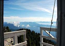
At Mount Pilchuck's summit is an old fire lookout, now used as shelter for hikers. This former lookout is jointly maintained by Washington State Parks and the Everett branch of The Mountaineers.
Some years the trail to the summit is still covered with snow until late in the summer.
References
- 1 2 "Mount Pilchuck, Washington". Peakbagger.com. Retrieved 2008-12-07.
- ↑ "Pilchuck Mtn Lookout House". NGS data sheet. U.S. National Geodetic Survey. Retrieved 2008-12-07.
- ↑ "View to the east from Mount Pichuck". Panoramio.com. Retrieved 2008-12-07.
- ↑ "View of Puget Sound from Mount Pichuck". Retrieved 2008-12-07.
External links
-
 Media related to Mount Pilchuck at Wikimedia Commons
 - "Mount Pilchuck". Geographic Names Information System. United States Geological Survey. Retrieved 2008-12-07.
- "Mount Pilchuck State Park". Washington State Parks. Retrieved 2008-12-07.