Mount Ida, Arkansas
| Mount Ida, Arkansas | |
|---|---|
| City | |
|
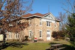
Montgomery County Courthouse in downtown Mount Ida | |
| Motto: "Quartz Crystal Capital of the World"[1] | |
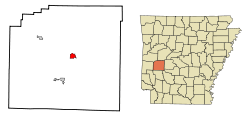 Location in Montgomery County and the state of Arkansas | |
| Coordinates: 34°33′14″N 93°37′50″W / 34.55389°N 93.63056°WCoordinates: 34°33′14″N 93°37′50″W / 34.55389°N 93.63056°W | |
| Country | United States |
| State | Arkansas |
| County | Montgomery |
| Incorporated (city) | May 30, 1890[2] |
| Area | |
| • Total | 1.6 sq mi (4.2 km2) |
| • Land | 1.6 sq mi (4.2 km2) |
| • Water | 0 sq mi (0 km2) |
| Elevation | 666 ft (203 m) |
| Population (2000) | |
| • Total | 1,076 |
| • Density | 613.1/sq mi (233.6/km2) |
| Time zone | Central (CST) (UTC-6) |
| • Summer (DST) | CDT (UTC-5) |
| ZIP code | 71957 |
| Area code(s) | 870 |
| FIPS code | 05-47690 |
| GNIS feature ID | 0077718 |
| Website | Mount Ida Chamber of Commerce |
Mount Ida is a city in and county seat of Montgomery County, Arkansas, United States. Founded in 1842, the city saw a silver boom in the 1880s bring early prosperity and economic development to the area. A slowly growing small town ever since, today, the economy is largely ranching, poultry farming, silviculture, and tourism around Lake Ouachita. It is officially known as the quartz crystal capital of the U.S. and is known worldwide for its quartz deposits.[1] The population had grown to 1,076 by the 2010 census.
History
Mount Ida was incorporated on May 30, 1890.[2]
Geography

Mount Ida is located at 34°33′14″N 93°37′50″W / 34.55389°N 93.63056°W (34.553879, -93.630641).[3]
According to the United States Census Bureau, the city has a total area of 1.7 square miles (4.4 km2), of which 1.6 square miles (4.1 km2) is land and 0.04 square miles (0.10 km2) (1.20%) is water.
Climate
The climate in this area is characterized by hot, humid summers and generally mild to cool winters. According to the Köppen Climate Classification system, Mount Ida has a humid subtropical climate, abbreviated "Cfa" on climate maps.[4]
Demographics
| Historical population | |||
|---|---|---|---|
| Census | Pop. | %± | |
| 1920 | 298 | — | |
| 1930 | 512 | 71.8% | |
| 1940 | 490 | −4.3% | |
| 1950 | 566 | 15.5% | |
| 1960 | 564 | −0.4% | |
| 1970 | 819 | 45.2% | |
| 1980 | 1,023 | 24.9% | |
| 1990 | 775 | −24.2% | |
| 2000 | 981 | 26.6% | |
| 2010 | 1,076 | 9.7% | |
| Est. 2015 | 1,025 | [5] | −4.7% |
As of the census[7] of 2000, there were 981 people, 412 households, and 257 families residing in the city. The population density was 598.5 people per square mile (231.0/km²). There were 471 housing units at an average density of 287.4/sq mi (110.9/km²). The racial makeup of the city was 96.53% White, 0.10% Black or African American, 1.94% Native American, 0.31% Asian, 0.10% from other races, and 1.02% from two or more races. 0.51% of the population were Hispanic or Latino of any race.
There were 412 households out of which 22.1% had children under the age of 18 living with them, 46.8% were married couples living together, 11.9% had a female householder with no husband present, and 37.6% were non-families. 35.4% of all households were made up of individuals and 23.3% had someone living alone who was 65 years of age or older. The average household size was 2.15 and the average family size was 2.74.
In the city the population was spread out with 19.2% under the age of 18, 6.6% from 18 to 24, 18.3% from 25 to 44, 21.7% from 45 to 64, and 34.1% who were 65 years of age or older. The median age was 50 years. For every 100 females there were 78.0 males. For every 100 females age 18 and over, there were 72.0 males.
The median income for a household in the city was $21,438, and the median income for a family was $30,714. Males had a median income of $25,875 versus $20,179 for females. The per capita income for the city was $13,532. About 18.9% of families and 23.4% of the population were below the poverty line, including 29.2% of those under age 18 and 16.0% of those age 65 or over.
Parks and recreation
The Ouachita National Forest is located in Montgomery County, and is close to Mount Ida. It is the South's oldest and largest national forest,[1] and offers scenic areas like Little Missouri Falls, and hiking and backpacking trails.[8]
Notable people
- James Alley, soldier with Easy Company, 2nd Battalion, 506th Parachute Infantry Regiment, in the 101st Airborne Division of the United States Army, portrayed in the miniseries Band of Brothers; born in Mount Ida.[9]
- Mark Davis, professional sport fisherman of the Bass Anglers Sportsman Society; born in Mount Ida.[10]
- Lon Warneke, Major League Baseball player, Major League umpire; born in Mount Ida.[11]
References
- 1 2 3 "Mount Ida Chamber of Commerce". Mount Ida Chamber of Commerce. Retrieved September 12, 2012.
- 1 2 "Mount Ida, Arkansas". City-Data.com. Retrieved September 12, 2012.
- ↑ "US Gazetteer files: 2010, 2000, and 1990". United States Census Bureau. 2011-02-12. Retrieved 2011-04-23.
- ↑ Climate Summary for Mount Ida, Arkansas
- ↑ "Annual Estimates of the Resident Population for Incorporated Places: April 1, 2010 to July 1, 2015". Retrieved July 2, 2016.
- ↑ "Census of Population and Housing". Census.gov. Retrieved June 4, 2015.
- ↑ "American FactFinder". United States Census Bureau. Retrieved 2008-01-31.
- ↑ "Mount Ida". The Official Site of Arkansas Department of Parks & Tourism. Retrieved September 12, 2012.
- ↑ Wikipedia page
- ↑ Mark Davis' Texas Bass Fishing Bio page
- ↑ Reichler, Joseph L., ed. (1979) [1969]. The Baseball Encyclopedia (4th ed.). New York: Macmillan Publishing. ISBN 0-02-578970-8.
External links
| Wikimedia Commons has media related to Mount Ida, Arkansas. |
- Mount Ida Weather & Attraction Information
- Mount Ida Chamber of Commerce Portal style website, Government, Business, Library, Recreation and more
- City-Data.com Comprehensive Statistical Data and more about Mount Ida
- ePodunk: Profile for Mount Ida, Arkansas, AR
Municipalities and communities of Montgomery County, Arkansas, United States | ||
|---|---|---|
| City | 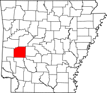 | |
| Towns | ||
| Unincorporated communities | ||
| Footnotes | ‡This populated place also has portions in an adjacent county or counties | |