Moorcroft, Wyoming
| Moorcroft, Wyoming | |
|---|---|
| Town | |
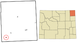 Location in Crook County and the state of Wyoming. | |
| Coordinates: 44°15′54″N 104°57′2″W / 44.26500°N 104.95056°WCoordinates: 44°15′54″N 104°57′2″W / 44.26500°N 104.95056°W | |
| Country | United States |
| State | Wyoming |
| County | Crook |
| Government | |
| • Mayor | Jay Chung |
| Area[1] | |
| • Total | 1.26 sq mi (3.26 km2) |
| • Land | 1.26 sq mi (3.26 km2) |
| • Water | 0 sq mi (0 km2) |
| Elevation | 4,226 ft (1,288 m) |
| Population (2010)[2] | |
| • Total | 1,009 |
| • Estimate (2012[3]) | 1,023 |
| • Density | 800.8/sq mi (309.2/km2) |
| Time zone | Mountain (MST) (UTC-7) |
| • Summer (DST) | MDT (UTC-6) |
| ZIP code | 82721 |
| Area code(s) | 307 |
| FIPS code | 56-54185[4] |
| GNIS feature ID | 1601528[5] |
| Website |
townofmoorcroft |
Moorcroft is a town in Crook County, Wyoming, United States. The population was 1,009 at the 2010 census.
History
Moorcroft was incorporated on October 2, 1906.[6] The exact meaning of Moorcroft is unknown but over the years has several suggested origins for the name. The town was named in 1876 after Alexander Moorcroft, an early settler who built a cabin in the Black Hills of Wyoming.[1][6][7][8] The name Moorcroft was chosen by the community’s first postman Stocks Millar (1858-1890) after his home town in Scotland .[1][7] Where the West Texas Trail crosses the highway. Herds of Texas longhorn cattle were pushed through here in the late 1800s giving the town its start, homesteaders came for the free land and Moorcroft was established. The thriving metropolis of Moorcroft had its beginning as a store, a saloon, and a roadhouse by the Belle Fourche River at the mouth of Donkey Creek and was known as LaBelle. LaBelle was located where the Texas Trail crosses Highway 16. In 1891, the Chicago, Burlington and Quincy Railroad Company built a railroad through what is now Moorcroft.
In the Old Gaelic language, Moorcroft means "Cottage on the Plains". The exact origin of the name Moorcroft is not definitely known. One of the following, or both, is true, as they are both recorded in the Wyoming State Archives and Historical Department:
When the post office was moved to the railroad depot, it was named Moorcroft by Stocks Millar, (the first postmaster in the area) who named it after his mother's maiden name, Moorhouse. Instead of naming it Moorhouse, he named it Moorcroft.
Another possibility is that Alexander Moorcroft, a physician, had it named after him because he was the first white man to brave the conditions and build his cabin here, in open defiance of the Sioux Indians who inhabited this rangeland about 1895 - 1890.
The land on which the original town of Moorcroft now rests was homesteaded by Martin H. Eckert when Benjamin Harrison was President of the United States. When the railroad went through, the Lincoln Land Company bought the 159 acre homestead for $1180.00 on May 22, 1891.
The coming of 1892 saw the extension of the railroad line to Gillette, and the establishment of a mail route between Moorcroft and Sundance. The stage made three trips a week with passengers and mail.
On May 16, 1892, there came to town a young man by the name of Lucian Holbrook Robinson. Shortly after he arrived, he founded Moorcroft's first store in a twelve by fourteen foot walled tent. The post office was moved to the store, and "Lou" served as postmaster for several years. The postmastership was turned over to J.K. Somers, who built the first hotel in 1897. Moorcroft was incorporated on October 2, 1906. Frank C. Haselton was elected Mayor, Charles Lewis was the Town Clerk, Dr. N. B. Newcomer was Treasurer, Steve Daily was Marshall and C. E. Kackley was Justice of the Peace. The long-term councilmen were W. K. Somers and John F. Daily, and the short term councilmen were J. L. Michaels and Charles Kirby.
Three very prominent gentlemen in Moorcroft in 1906 were, L.H. Robinson, John W. Rogers, and W.J. McCrea. These men were the executives of the newly organized Moorcroft Bank and the newly incorporated Robinson Mercantile Company. L.H. Robinson served as President of both, John W. Rogers was vice-president at the bank and secretary-treasurer of the Mercantile Company, and W.J. McCrea was vice-president of the company and cashier at the bank.
In the early 1900s, the sales from the Robinson Mercantile often exceeded a quarter million dollars per year. The store handled everything a farmer would need. Anything from food to barbed wire and sheep wagons, and also livestock feed and seed for farming could be bought at the store. These items were shipped in on the railroad in carload lots.
George Briggs and his son, Stewart, built the first lumberyard. J.L. Michaels operated the first barbershop and pool hall. There were two tables in the pool hall, and by a city ordinance, the license to operate cost $5.00 per table. In the barbershop one could get a bath for 25 cents, a shave for 25 cents, and a haircut for 50 cents.
W.K. Somers was the lawyer in Moorcroft, and he was also a United States Commissioner. Dr. N.H. Baker was the first Doctor to establish an office in Moorcroft. He also owned the first Drug Store. The first grain elevator, which was built by Bill Rife and Charles Schilling, burned down. The cemetery was bought from L.H. Robinson, an agent for the Lincoln Land Company, on January 13, 1908, for $100.00. The first person buried in the cemetery was "Diamond" Joe Thompson.
In 2008, the town elected Jay Chung as mayor. He is the first Asian-American mayor in the state of Wyoming.
Information has been taken from the Historical Encyclopedia of Wyoming - "A History of Crook County", by Helen R. Zimmerschied.
Geography
Moorcroft is located at 44°15′54″N 104°57′2″W / 44.26500°N 104.95056°W (44.264863, -104.950663).[9]
According to the United States Census Bureau, the town has a total area of 1.26 square miles (3.26 km2), all of it land.[1]
Demographics
| Historical population | |||
|---|---|---|---|
| Census | Pop. | %± | |
| 1910 | 178 | — | |
| 1920 | 420 | 136.0% | |
| 1930 | 341 | −18.8% | |
| 1940 | 387 | 13.5% | |
| 1950 | 517 | 33.6% | |
| 1960 | 826 | 59.8% | |
| 1970 | 981 | 18.8% | |
| 1980 | 1,014 | 3.4% | |
| 1990 | 768 | −24.3% | |
| 2000 | 807 | 5.1% | |
| 2010 | 1,009 | 25.0% | |
| Est. 2015 | 1,062 | [10] | 5.3% |
2010 census
As of the census[2] of 2010, there were 1,009 people, 392 households, and 254 families residing in the town. The population density was 800.8 inhabitants per square mile (309.2/km2). There were 442 housing units at an average density of 350.8 per square mile (135.4/km2). The racial makeup of the town was 96.7% White, 0.9% Native American, 0.1% Asian, 1.0% from other races, and 1.3% from two or more races. Hispanic or Latino of any race were 4.5% of the population.
There were 392 households of which 34.4% had children under the age of 18 living with them, 50.0% were married couples living together, 10.7% had a female householder with no husband present, 4.1% had a male householder with no wife present, and 35.2% were non-families. 27.6% of all households were made up of individuals and 6.3% had someone living alone who was 65 years of age or older. The average household size was 2.57 and the average family size was 3.20.
The median age in the town was 32.6 years. 30.3% of residents were under the age of 18; 9.7% were between the ages of 18 and 24; 23.7% were from 25 to 44; 26.4% were from 45 to 64; and 9.7% were 65 years of age or older. The gender makeup of the town was 49.8% male and 50.2% female.
2000 census
As of the census[4] of 2000, there were 807 people, 325 households, and 219 families residing in the town. The population density was 731.4 people per square mile (283.3/km²). There were 375 housing units at an average density of 339.9 per square mile (131.6/km²). The racial makeup of the town was 98.1% White, 1.0% Native American, 0.3% from other races, and 0.6% from two or more races. Hispanic or Latino of any race were 1.4% of the population.
There were 325 households out of which 34.5% had children under the age of 18 living with them, 56.0% were married couples living together, 7.7% had a female householder with no husband present, and 32.6% were non-families. 25.8% of all households were made up of individuals and 9.8% had someone living alone who was 65 years of age or older. The average household size was 2.48 and the average family size was 3.04.
In the town the population was spread out with 27.3% under the age of 18, 11.3% from 18 to 24, 27.4% from 25 to 44, 24.3% from 45 to 64, and 9.8% who were 65 years of age or older. The median age was 36 years. For every 100 females there were 99.8 males. For every 100 females age 18 and over, there were 99.7 males.
The median income for a household in the town was $36,953, and the median income for a family was $41,484. Males had a median income of $32,109 versus $19,632 for females. The per capita income for the town was $16,476. About 2.6% of families and 5.2% of the population were below the poverty line, including 4.5% of those under age 18 and 7.2% of those age 65 or over.
Education
Public education in the town of Moorcroft is provided by Crook County School District #1. Zoned campuses include Moorcroft Elementary School (grades K-6) and Moorcroft Secondary School (grades 7-12).
Notable people
American country music singer-songwriter and former saddle bronc rider, Chancey Williams was born in Moorcroft, Wyoming.
References
- 1 2 3 4 "US Gazetteer files 2010". United States Census Bureau. Retrieved 2012-12-14.
- 1 2 "American FactFinder". United States Census Bureau. Retrieved 2012-12-14.
- ↑ "Population Estimates". United States Census Bureau. Retrieved 2013-06-01.
- 1 2 "American FactFinder". United States Census Bureau. Retrieved 2008-01-31.
- ↑ "US Board on Geographic Names". United States Geological Survey. 2007-10-25. Retrieved 2008-01-31.
- 1 2 "Profile for Moorcroft, Wyoming". ePodunk. Retrieved 2010-05-28.
- 1 2 http://www.wyomingtalesandtrails.com/moorcroft.html
- ↑ Encyclopedia of Wyoming by Nancy Capace p239 North American Book Dist LLC, 2001
- ↑ "US Gazetteer files: 2010, 2000, and 1990". United States Census Bureau. 2011-02-12. Retrieved 2011-04-23.
- ↑ "Annual Estimates of the Resident Population for Incorporated Places: April 1, 2010 to July 1, 2015". Retrieved July 2, 2016.
- ↑ "Census of Population and Housing". Census.gov. Retrieved June 4, 2015.
External links
-
 Moorcroft travel guide from Wikivoyage
Municipalities and communities of Crook County, Wyoming, United States | ||
|---|---|---|
| Towns | 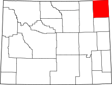 | |
| CDP | ||
| Unincorporated communities | ||