Moon Bay


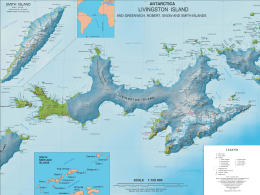
Moon Bay is a bay 7 nautical miles (13 km) wide which recedes 4 nautical miles (7 km) between Edinburgh Hill and Renier Point, on the east side of Livingston Island, in the South Shetland Islands off Antarctica. The glaciers Sopot Ice Piedmont, Iskar, Huron, Struma, Kaliakra, Panega and Debelt feed the bay.
The bay was known to sealers in the area as early as 1821. It was recharted in 1935 by Discovery Investigations personnel on the Discovery II, and probably named by them for nearby Half Moon Island, which lies in the entrance to the bay.[1][2]
Maps
- South Shetland Islands. Scale 1:200000 topographic map No. 5657. DOS 610 – W 62 60. Tolworth, UK, 1968.
- Islas Livingston y Decepción. Mapa topográfico a escala 1:100000. Madrid: Servicio Geográfico del Ejército, 1991.
- L.L. Ivanov et al. Antarctica: Livingston Island and Greenwich Island, South Shetland Islands. Scale 1:100000 topographic map. Sofia: Antarctic Place-names Commission of Bulgaria, 2005.
- L.L. Ivanov. Antarctica: Livingston Island and Greenwich, Robert, Snow and Smith Islands. Scale 1:120000 topographic map. Troyan: Manfred Wörner Foundation, 2009. ISBN 978-954-92032-6-4
- Antarctic Digital Database (ADD). Scale 1:250000 topographic map of Antarctica. Scientific Committee on Antarctic Research (SCAR), 1993–2016.
References
- ↑ "Moon Bay". Geographic Names Information System. United States Geological Survey. Retrieved 2013-11-04.
- ↑ Alberts, Fred G., ed. (June 1995). Geographic Names of the Antarctic (PDF) (second ed.). United States Board on Geographic Names. p. 502. Retrieved 5 April 2012.
![]() This article incorporates public domain material from the United States Geological Survey document "Moon Bay" (content from the Geographic Names Information System).
Coordinates: 62°35′S 60°0′W / 62.583°S 60.000°W
This article incorporates public domain material from the United States Geological Survey document "Moon Bay" (content from the Geographic Names Information System).
Coordinates: 62°35′S 60°0′W / 62.583°S 60.000°W