Renier Point

Location of Burgas Peninsula, Livingston Island in the South Shetland Islands.
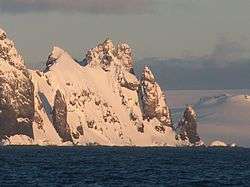
Renier Point from Bransfield Strait.
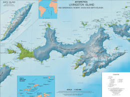
Topographic map of Livingston Island.
Renier Point (62°36′34″S 59°48′21″W / 62.60944°S 59.80583°WCoordinates: 62°36′34″S 59°48′21″W / 62.60944°S 59.80583°W) is a narrow point forming the east extremity of both Burgas Peninsula and Livingston Island in the South Shetland Islands, Antarctica. The feature was known to sealers as Point Renier as early as 1821. The name ‘Pin Point’, given by Discovery Investigations personnel on the Discovery II in 1935, has been rejected in favor of the original name.
Maps
- L.L. Ivanov et al. Antarctica: Livingston Island and Greenwich Island, South Shetland Islands. Scale 1:100000 topographic map. Sofia: Antarctic Place-names Commission of Bulgaria, 2005.
- L.L. Ivanov. Antarctica: Livingston Island and Greenwich, Robert, Snow and Smith Islands. Scale 1:120000 topographic map. Troyan: Manfred Wörner Foundation, 2009. ISBN 978-954-92032-6-4
![]() This article incorporates public domain material from the United States Geological Survey document "Renier Point" (content from the Geographic Names Information System).
This article incorporates public domain material from the United States Geological Survey document "Renier Point" (content from the Geographic Names Information System).
This article is issued from Wikipedia - version of the 11/21/2015. The text is available under the Creative Commons Attribution/Share Alike but additional terms may apply for the media files.