Mook en Middelaar
| Mook en Middelaar Mook en Middelar | ||
|---|---|---|
| Municipality | ||
|
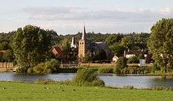
Mook town centre across the Meuse | ||
| ||
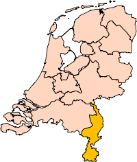
.svg.png) Location in Limburg | ||
| Coordinates: 51°45′N 5°53′E / 51.750°N 5.883°ECoordinates: 51°45′N 5°53′E / 51.750°N 5.883°E | ||
| Country | Netherlands | |
| Province | Limburg | |
| Government[1] | ||
| • Body | Municipal council | |
| • Mayor | Willem Gradisen (PvdA) | |
| Area[2] | ||
| • Total | 18.81 km2 (7.26 sq mi) | |
| • Land | 17.39 km2 (6.71 sq mi) | |
| • Water | 1.42 km2 (0.55 sq mi) | |
| Elevation[3] | 12 m (39 ft) | |
| Population (May 2014)[4] | ||
| • Total | 7,773 | |
| • Density | 447/km2 (1,160/sq mi) | |
| Time zone | CET (UTC+1) | |
| • Summer (DST) | CEST (UTC+2) | |
| Postcode | 6584–6587 | |
| Area code | 024 | |
| Website |
mookenmiddelaar | |

Mook en Middelaar (Dutch pronunciation: [ˈmoːk ən ˈmɪdəlaːr], Limburgish: Mook en Middelar) is a municipality in the upper southeastern part of the Netherlands, at the northern tip of the province of Limburg and is a part of Stadsregio Arnhem Nijmegen. The municipality is located about 100 km from provincial capital Maastricht and has an area of 18.81 km2 (7.26 sq mi) of which 1.42 km2 (0.55 sq mi) is water.
Population centres
History
The municipality is situated in wooded rolling moraine landscape, created during the last Ice Age, about 160,000 years ago.
In Plasmolen the remains of a Roman villa from the 2nd century AD were found and on the banks of the Meuse are the remains of a Roman bridge. These remains are from the 4th century.
The Mookerheide ("Mook Heath"), situated on the border of Mook, saw the Battle of Mookerheyde in 1574 which was fought as part of the Eighty Years War. Spanish forces under Sancho d'Avila defeated the rebel forces of Louis of Nassau, who was killed.
The Mookerschans and Heumense schans were defenses on the Mookerheide probably from the 17th century. (At that time the Mookerheide area extended all the way to the citywalls of Nijmegen) The historical Mookerheideschans (defense work) has been restored and offers a beautiful view over the Meuse valley.
Middelaar belonged to Overkwartier (Upper Quarter) of Guelders or Upper Guelders. During the War of the Spanish Succession Middelaar was occupied by Prussian troops, and it remained German for about a century (until 1814).
In the Second World War a fierce battle raged around this area. In May 1940 the invaders were stopped by large bunkers on the Brabant-side of the Meuse, the railway bridge between Mook and Katwijk was blown up. In September 1944 Mook, Plasmolen and Middelaar were in the front area and the war caused much devastation. While under fire of German guns that were shooting from the woods near Groesbeek, allied soldiers had to secure the Heumen bridge over the Maas-Waal canal that was an important hub for operation Market Garden. Fierce fighting caused the front to move so the little village, of which most houses were shot in this period, was liberated to fall back in German hands, to be liberated again. Soldiers killed in this vicinity during World War II found their final restingplace in Mook War Cemetery Most inhabitants of Mook and Middelaar sought refuge elsewhere until the liberation.
To support the cement industry, sand was dug out in the fields next to the river Maas (known as 'Cuyksesteeg') which consequently lead to the forming of the Mookerplassen recreational lakes, between Middelaar and the Mookerheide. After a couple of floodings in the 80's and 90's a removable lock was built to save the area from flooding again.
Gallery
 Mook, former town hall
 Mook, church
 Mookerplas
 Middelaar, church
 Mookerheide near Mook
Public transport
Mook and the municipality is served by three bus lines and has its own train station, Mook-Molenhoek railway station.
Notable residents
- Arjen Teeuwissen (born 1971), equestrian
References
- ↑ "College van burgemeester en wethouders" [Board of mayor and aldermen] (in Dutch). Gemeente Mook en Middelaar. Retrieved 11 November 2013.
- ↑ "Kerncijfers wijken en buurten" [Key figures for neighbourhoods]. CBS Statline (in Dutch). CBS. 2 July 2013. Retrieved 12 March 2014.
- ↑ "Postcodetool for 6585AP". Actueel Hoogtebestand Nederland (in Dutch). Het Waterschapshuis. Retrieved 11 November 2013.
- ↑ "Bevolkingsontwikkeling; regio per maand" [Population growth; regions per month]. CBS Statline (in Dutch). CBS. 26 June 2014. Retrieved 24 July 2014.
External links
 Media related to Mook en Middelaar at Wikimedia Commons
- Official website
 |
Heumen (GE) | Berg en Dal (GE) | | |
| |
||||
| ||||
| | ||||
| Meuse Cuijk (NB) |
Gennep |