Kerkrade
| Kerkrade Kirchroa | |||
|---|---|---|---|
| Municipality | |||
|
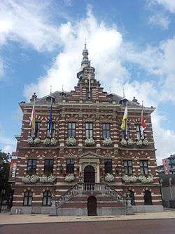
Kerkrade city hall | |||
| |||
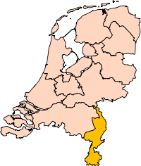
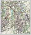
.svg.png) Location in Limburg | |||
| Coordinates: 50°52′N 6°4′E / 50.867°N 6.067°ECoordinates: 50°52′N 6°4′E / 50.867°N 6.067°E | |||
| Country | Netherlands | ||
| Province | Limburg | ||
| Government[1] | |||
| • Body | Municipal council | ||
| • Mayor | Jos Som (CDA) | ||
| Area[2] | |||
| • Total | 22.13 km2 (8.54 sq mi) | ||
| • Land | 21.90 km2 (8.46 sq mi) | ||
| • Water | 0.23 km2 (0.09 sq mi) | ||
| Elevation[3] | 155 m (509 ft) | ||
| Population (May 2014)[4] | |||
| • Total | 46,627 | ||
| • Density | 2,129/km2 (5,510/sq mi) | ||
| Demonym(s) | Kerkradenaar | ||
| Time zone | CET (UTC+1) | ||
| • Summer (DST) | CEST (UTC+2) | ||
| Postcode | 6460–6471 | ||
| Area code | 045 | ||
| Website |
www | ||


Kerkrade ([ˈkɛrkraːdə], Kerkrade dialect: Kirchroa [ˈkeʁçʁoə̯]) is a town and a municipality in the southeast of Limburg, the southernmost province of the Netherlands.
Kerkrade is the western half of a divided city; before the independence of the Netherlands, it was part of the German town of Herzogenrath. The two towns, including outlying suburban settlements, have a population approaching 100,000, of which nearly 47,000 in Kerkrade.
History
The history of Kerkrade is closely linked with that of the adjacent town of Herzogenrath, just across the German border.[5] Herzogenrath began as a settlement, called Rode, near the river Worm (or Wurm in German) in the 11th century. In 1104 Augustinian monks founded an abbey, called Kloosterrade, to the west of this settlement.
It was called 's-Hertogenrode or 's-Hertogenrade (Dutch: the Duke's Rode) after the duchy of Brabant took control over the region; in French it was called Rolduc (Rode-le-duc). As is the case for many parts of the Southern Netherlands, the place changed hands several times in the last few centuries. It was under Spanish control from 1661, Austrian between 1713 and 1785 and French between 1795 and 1813. In 1815, when the kingdom of the Netherlands was formed (see Vienna Congress), the border was drawn through Herzogenrath, the western part being Kerkrade.
In the 18th century the monks of Rolduc began small-scale coal mines. More modern exploitation by others started in 1860, causing Kerkrade to grow significantly, especially as a consequence of the permanent settlement of mainly Southern-European miners in this Northern-European place. When the Willem Sophia mine was opened around 1900, the town grew even more rapidly, absorbing old villages like Chèvremont. In the decades following 1960, all the mines in Limburg were closed.
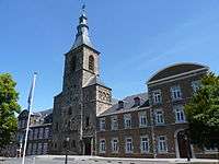
One of the oldest buildings in the municipality is Erenstein, a castle the origins of which lie in the 14th century.
The border along Nieuwstraat/Neustraße
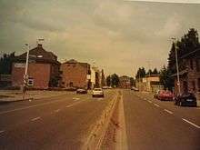

One part of the border between the Netherlands and Germany runs along the middle of the street Nieuwstraat/Neustraße. Because of relatively unrestricted cross-border travel within the European Union, this border was for many years marked only with a low wall, about 30 cm high, running along the length of the street (borders were at that time designed to be unpassable by vehicles, except at border crossing, but no fence for pedestrians). There was a separate 2-way road on each side, and cars had to pass through the official crossing points, but pedestrians could readily step over the wall (although there were signs informing of the border). In 1995, it was decided to remove the wall completely. Nieuwstraat/Neustraße is now a single two-way road, with the extra space now occupied with trees and bicycle lanes. The border is unmarked, and is crossed even when going round a roundabout or overtaking a vehicle.
Population centres

Kerkrade's outlying neighborhoods and housing developments include:
- Eygelshoven
- Kaalheide
- Bleijerheide
- Spekholzerheide
- Terwinselen
- Holz
- Rolduckerveld
- Hopel
- Chevremont
- Haanrade
- Gracht
- Mucherveld
- Nulland
- Rolduc
Music
Every fourth year the World Music Contest, a competition for amateur, professional, and military bands, is held in Kerkrade.[6] Also, for the last three years, the Drum Corps Europe championships have been held here.
Transportation
Kerkrade has 4 railway stations:
Another station, Kerkrade West or Spekholzerheide, closed for public rail in 1988, and since 1992 it is in use by a museum-railway company, ZLSM.
Reservoir
The building of a dam in the Anstel, a brook flowing west of Kerkrade, has led to the formation of a reservoir with an area of about 20 ha. This and its surroundings are very rich in flora and fauna. It is the only reservoir in the Netherlands.
Sports
- Roda JC (soccer)
Notable natives of Kerkrade
- Wiel Coerver (born 1924)- footballer and manager
- Willy Brokamp (born 1946) – footballer
- Gerd Leers (born 1951) – politician
- Heintje Simons (born 1955) – singer
- Pierre Vermeulen (born 1956) – footballer
- René Trost (born 1965) – footballer
- Sieb Dijkstra (born 1966) – footballer
- Jörg Müller (born 1969) – race driver
- Roy Bejas (born 1987) – footballer
See also
References
- ↑ "Het college" [The board of mayor and aldermen] (in Dutch). Gemeente Kerkrade. Retrieved 29 October 2013.
- ↑ "Kerncijfers wijken en buurten" [Key figures for neighbourhoods]. CBS Statline (in Dutch). CBS. 2 July 2013. Retrieved 12 March 2014.
- ↑ "Postcodetool for 6461EC". Actueel Hoogtebestand Nederland (in Dutch). Het Waterschapshuis. Retrieved 29 October 2013.
- ↑ "Bevolkingsontwikkeling; regio per maand" [Population growth; regions per month]. CBS Statline (in Dutch). CBS. 26 June 2014. Retrieved 24 July 2014.
- ↑ Stenvert, R. et al. (2003). Monumenten in Nederland: Limburg, p. 173–178. Zwolle: Waanders Uitgevers. ISBN 90-400-9623-6.
- ↑ "World Music Contest opens in Kerkrade". Radio Netherlands Worldwide. 12 July 2009. Retrieved 22 August 2011.
External links
| Wikimedia Commons has media related to Kerkrade. |
 Kerkrade travel guide from Wikivoyage
- Official website
 |
Landgraaf | | ||
| Heerlen | |
Herzogenrath (DE-NW) | ||
| ||||
| | ||||
| Aachen (DE-NW) |