Mons Pico
| Mons Pico | |
|---|---|
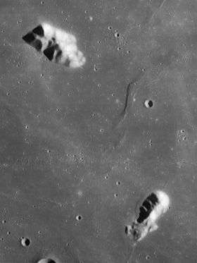 Mons Pico (upper left) and Pico β (lower right). Lunar Orbiter 4 image. | |
| Highest point | |
| Elevation | 2.4 km |
| Listing | Lunar mountains |
| Coordinates | 45°42′N 8°54′W / 45.7°N 8.9°W |
| Geography | |
| Location | the Moon |
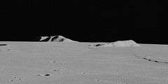
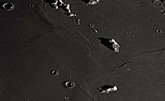

Mons Pico is a solitary lunar mountain that lies in the northern part of the Mare Imbrium basin, to the south of the dark-floored crater Plato and on the southern rim of a ghost crater.[1] This peak forms part of the surviving inner ring of the Imbrium basin, continuing to the northwest and with the Montes Teneriffe and Montes Recti ranges, and probably to the southeast with the Montes Spitzbergen. This mountain feature was most likely named by Schröter for the Pico von Teneriffe (Teide).[2]
The selenographic coordinates of this peak are 45.7° N, 8.9° W. It forms an elongated feature with a length of 25 kilometers (oriented northwest-southeast) and a width of 15 km. The peak rises to a height of only 2.4 km, comparable to the maximum altitude of the Montes Teneriffe. The mountain itself is a very reflective and bright object.[1] Due to its isolated location on the lunar mare, however, this peak can form prominent shadows when illuminated by oblique sunlight. It is also known as a location of Transient Lunar Anomalies.[1]
A smaller peak to the southeast of Mons Pico is sometimes called Mons Pico β (Beta),[3][4] although this does not appear to be recognized by the IAU. This region of the mare is notable for a number of wrinkle ridges.
Satellite craters
By convention these features are identified on lunar maps by placing the letter on the side of the crater midpoint that is closest to Mons Pico.
| Pico | Latitude | Longitude | Diameter |
|---|---|---|---|
| B | 46.5° N | 15.3° W | 12 km |
| C | 47.2° N | 6.6° W | 5 km |
| D | 43.4° N | 11.3° W | 7 km |
| E | 43.0° N | 10.3° W | 9 km |
| F | 42.2° N | 10.2° W | 4 km |
| G | 46.6° N | 10.4° W | 4 km |
| K | 44.6° N | 7.5° W | 3 km |
Pico in fiction
Strange objects appear near Pico in the 1957 science fiction novel Blast Off at Woomera by Hugh Walters; their fate is further expanded upon in the sequels The Domes of Pico and Operation Columbus.
Pico is the site of a climactic space battle in Arthur C. Clarke's novel Earthlight, mentioned in passing in his novel 3001: The Final Odyssey as a storage repository of both biological and computer viruses, and in his short story "The Sentinel" (in which Wilson, the protagonist, mentions having climbed it).
See also
References
<div class="reflist columns references-column-width" style="-moz-column-width: [2] [4] [3] [1]; -webkit-column-width: [2] [4] [3] [1]; column-width: [2] [4] [3] [1]; list-style-type: decimal;">
- 1 2 3 4 5 6 North, Gerald (2007). Observing the Moon (Second ed.). New York: Cambridge University Press. p. 291. ISBN 978-0-521-87407-6.
- 1 2 3 4 Rükl, Antonín (1996). Atlas of the Moon. Waukesha, Wi.: Kalmbach Publishing Co. p. 48. ISBN 0-913135-17-8.
- 1 2 3 4 Bussey, Ben; Spudis, Paul (2004). The Clementine Atlas of the Moon (Revised ed.). Cambridge: Cambridge University Press. ISBN 0-521-81528-2.
- 1 2 3 4 Rükl, 49.
External links
Coordinates: 45°42′N 8°54′W / 45.700°N 8.900°W