Mare Imbrium
|
A map showing the location of Mare Imbrium | |
| Coordinates | 32°48′N 15°36′W / 32.8°N 15.6°WCoordinates: 32°48′N 15°36′W / 32.8°N 15.6°W |
|---|---|
| Diameter | 1,145 km (711 mi)[1] |
| Eponym | Sea of Showers or Sea of Rains |

.png)

Mare Imbrium (Latin for "Sea of Showers" or "Sea of Rains") is a vast lava plain within the Imbrium Basin on the Moon and is one of the larger craters in the Solar System, if even that. The Imbrium Basin formed from the collision of a proto-planet during the Late Heavy Bombardment. Basaltic lava later flooded the giant crater to form the flat volcanic plain seen today. The basin's age has been estimated using U-Pb dating methods to 3938 ± 4 million years ago,[2] the diameter of the impactor has been estimated to be 250 ± 25 km.[3] The Moon's maria (plural of mare) have fewer features than other areas of the Moon because molten lava pooled in the craters and formed a relatively smooth surface. Mare Imbrium is not as flat as it was originally because later events have altered its surface.
Origin
Mare Imbrium may have been formed when a proto-planet in the asteroid belt collided with the moon, 3.8 billion years ago.[4][5]
Characteristics
With a diameter of 1146 km, Mare Imbrium is second only to Oceanus Procellarum in size among the maria, and it is the largest mare associated with an impact basin.
The Imbrium Basin is surrounded by three concentric rings of mountains, uplifted by the colossal impact event that excavated it. The outermost ring of mountains has a diameter of 1300 km and is divided into several different ranges; the Montes Carpatus to the south, the Montes Apenninus to the southeast, and the Montes Caucasus to the east. The ring mountains are not as well developed to the north and west, and it appears they were simply not raised as high in these regions by the Imbrium impact. The middle ring of mountains forms the Montes Alpes and the mountainous regions near the craters Archimedes and Plato. The innermost ring, with a diameter of 600 km, has been largely buried under the mare's basalt leaving only low hills protruding through the mare plains and mare ridges forming a roughly circular pattern.
The outer ring of mountains rise roughly 7 km above the surface of Mare Imbrium. The Mare material is thought to be about 5 km deep, giving the Imbrium Basin a total depth of 12 km; it is thought that the original crater left by the Imbrium impact was as much as 100 km deep, but that the floor of the basin bounced back upwards immediately afterwards.
Surrounding the Imbrium Basin is a region blanketed by ejecta from the impact, extending roughly 800 km outward. Also encircling the basin is a pattern of radial grooves called the "Imbrium Sculpture", which have been interpreted as furrows cut in the Moon's surface by large projectiles blasted out of the basin at low angles, causing them to skim across the lunar surface ploughing out these features. Furthermore, a Moon-wide pattern of faults which run both radial to and concentric to the Imbrium basin were thought to have been formed by the Imbrium impact; the event literally shattered the Moon's entire lithosphere. At the region of the Moon's surface exactly opposite Imbrium Basin, there is a region of chaotic terrain (the crater Van de Graaff) which is thought to have been formed when the seismic waves of the impact were focused there after travelling through the Moon's interior. Mare Imbrium is about 750 miles (1,210 km) long.
A mass concentration (mascon), or gravitational high, was identified in the center of Mare Imbrium from Doppler tracking of the five Lunar Orbiter spacecraft in 1968.[6] The Imbrium mascon is the largest on the moon. The mascon was confirmed and mapped at higher resolution with later orbiters such as Lunar Prospector and GRAIL.
-

Shaded Relief map
-

Gravity map based on GRAIL
Names
Like most of the other maria on the Moon, Mare Imbrium was named by Giovanni Riccioli, whose 1651 nomenclature system has become standardized.[7]
The earliest known name for the mare may be "The Shrine of Hecate"; Plutarch records that the Ancient Greeks gave this name to the largest of the "hollows and deeps" on the Moon, believing it to be the place where the souls of the deceased were tormented. Ewen A. Whitaker argues that this likely refers to Mare Imbrium, "the largest regular-shaped dark area unbroken by bright patches" that can be seen with the naked eye.[8]
Around 1600, William Gilbert made a map of the Moon that names Mare Imbrium "Regio Magna Orientalis" (the Large Eastern Region). Michael van Langren's 1645 map named it "Mare Austriacum" (the Austrian Sea).[9]
Observation and exploration
Mare Imbrium is visible to the naked eye from Earth. In the traditional 'Man in the Moon' image seen on the Moon in Western folklore, Mare Imbrium forms the man's right eye.[10]
Luna 17
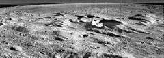
On the 17th of November 1970 at 03:47 Universal Time, the Soviet spacecraft Luna 17 made a soft landing in the mare, at latitude 38.28 N, and longitude 35.00 W. Luna 17 carried Lunokhod 1, the first rover to be deployed on the Moon. Lunokhod 1, a remote-controlled rover, was successfully deployed and undertook a mission lasting several months.
Apollo 15
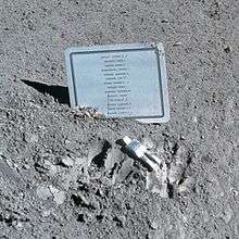
In 1971, the crewed Apollo 15 mission landed in the southeastern region of Mare Imbrium, between Hadley Rille and the Apennine Mountains. Commander David Scott and Lunar Module Pilot James Irwin spent three days on the surface of the Moon, including 18½ hours outside the spacecraft on lunar extra-vehicular activity. Command Module Pilot Alfred Worden remained in orbit and acquired hundreds of high-resolution photographs of Mare Imbrium (and other regions of the moon) as well as other types of scientific data. The crew on the surface explored the area using the first lunar rover and returned to Earth with 77 kilograms (170 lb) of lunar surface material. The astronauts of Apollo 15 had carried, without authorization, 398 commemorative postage stamp covers to sell them upon their return – this resulted in the Apollo 15 postage stamp incident. Furthermore, the astronauts had, without authorization from NASA, left the Fallen Astronaut sculpture, which commemorated astronauts and cosmonauts who had died (to date) in the advancement of space exploration.
2013 Impact
On March 17, 2013, an object hit the lunar surface in Mare Imbrium and exploded in a flash of apparent magnitude 4.[11] The crater could be as wide as 20 meters. This was the brightest impact recorded since NASA’s lunar impact team began monitoring in 2005.
Chinese lander
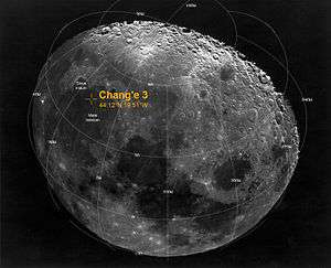
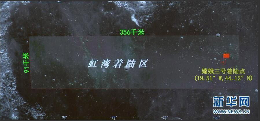
Chang'e 3 landed on 14 December 2013 on Mare Imbrium, about 40 km south of the 6 km diameter Laplace F crater,[12][13] at 44.1260°N 19.5014°W.[13][14][15] The lander deployed the Yutu rover 7 hours and 24 minutes later.[16] Chang'e 3 mission will attempt to perform the first direct measurement of the structure and depth of the lunar soil down to a depth of 30 m (98 ft), and investigate the lunar crust structure down to several hundred meters deep.[17]
See also
References
- ↑ "Moon Mare/Maria". Gazetteer of Planetary Nomenclature. USGS Astrogeology. Retrieved 2010-08-20.
- ↑ Merle, R. E.; Nemchin, A. A.; Grange, M. L.; Whitehouse, M. J.; Pidgeon, R. T. (2014). "High resolution U-Pb ages of Ca-phosphates in Apollo 14 breccias: Implications for the age of the Imbrium impact". Meteoritics & Planetary Science. 49 (12): 2241. doi:10.1111/maps.12395.
- ↑ P. H. Schultz & D.A. Crawford, Origin and implications of non-radial Imbrium Sculpture on the Moon, Nature 535, 391–394 (2016)
- ↑ Schultz, Peter H.; Crawford, David A. (2016-07-21). "Origin and implications of non-radial Imbrium Sculpture on the Moon". Nature. 535 (7612): 391–394. doi:10.1038/nature18278. ISSN 0028-0836.
- ↑ "Asteroid that formed Moon's Imbrium Basin may have been protoplanet-sized | News from Brown". news.brown.edu. Retrieved 2016-07-22.
- ↑ P. M. Muller, W. L. Sjogren (1968). "Mascons: Lunar Mass Concentrations". Science. 161 (3842): 680–684. doi:10.1126/science.161.3842.680.
- ↑ Ewen A. Whitaker, Mapping and Naming the Moon (Cambridge University Press, 1999), p.61.
- ↑ Ewen A. Whitaker, Mapping and Naming the Moon (Cambridge University Press, 1999), p.7
- ↑ Ewen A. Whitaker, Mapping and Naming the Moon (Cambridge University Press, 1999), pp.15, 41.
- ↑ Ewen A. Whitaker, Mapping and Naming the Moon (Cambridge University Press, 1999), p.3.
- ↑ Dr. Tony Phillips (May 17, 2013). "Bright Explosion on the Moon". Science@NASA. Retrieved 2013-05-19.
- ↑ "Chang'e 3 landing coordinates". China News (CN). 14 December 2013. Retrieved 2013-12-15.
- 1 2 Emily Lakdawalla; Phil Stooke (December 2013). "Chang'e 3 has successfully landed on the Moon!". The Planetary Society. Retrieved 2013-12-15.
- ↑ "China successfully lands robotic rover on the moon>".
- ↑ "Landing map of Chang'e 3".
- ↑ O'Neil, Ian (14 December 2013). "China's Rover Rolls! Yutu Begins Moon Mission". Discovery News. CCTV. Retrieved 2013-12-15.
- ↑ "欧阳自远:嫦娥三号明年发射将实现着陆器与月球车联合探测". Xinhua. 14 June 2012. Retrieved 23 July 2013.
External links
- Phillips, Tony (2006-06-13). "A Meteoroid Hits the Moon". Science@NASA. Retrieved 2006-06-16.