Mohawk, Montgomery County, New York
| Mohawk | |
| Town | |
| Country | United States |
|---|---|
| State | New York |
| County | Montgomery |
| Population | 3,844 (2010) |
| Town supervisor | Gregory W. Rajkowski (NP)
|
| Timezone | EST (UTC−05) |
| - summer (DST) | EDT (UTC−04) |
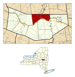 Location in Montgomery County and the state of New York. | |
Mohawk is a town in Montgomery County, New York, United States. The population was 3,844 at the 2010 census.
The Town of Mohawk is on the north border of the county, west of the City of Amsterdam. The county seat, Fonda, is located in Mohawk.
History
Jesuit missionaries entered this region from Quebec around 1642 to work among the Mohawk. The principal village of the Mohawk was Caughnawaga, which was later developed as the site of Fonda.
The Town was settled around 1725 by colonists from the English/Dutch region to the east around Albany. The Mohawk District, which became the original Town of Mohawk, was created in March 1772 by Sir William Johnson when Tryon County was split off from Albany County. It was the easternmost of five districts in the new county, which eastern boundary ran north from the Delaware River at the Pennsylvania line through present Schoharie County to a north-south line that now forms the eastern boundaries of Montgomery, Fulton, and Hamilton Counties, all the way to Canada. The district's western limit was an arbitrary north-south line drawn through "the noses", prominent rock prominences through which the Mohawk River flows four miles east of Canajoharie (on the south side).
During the American Revolution, the town was invaded in 1780 by an army of Indians and Tories in 1780. The original District or "Town of Mohawk" was eliminated in 1793 by its division into the Towns of Florida and Charleston. The present town was created from part of the Town of Johnstown in 1837.
In 1865, the population of Mohawk was 2,948.
Geography
According to the United States Census Bureau, the town has a total area of 35.4 sq mi (92 km2), of which, 34.7 sq mi (90 km2) of it is land and 0.7 sq mi (1.8 km2) of it (1.92%) is water.
The north town line is the border of Fulton County, New York, and the south town line is defined by the Mohawk River.
New York State Route 5 parallels the Mohawk River. New York State Route 30A and New York State Route 334 intersect NY-5 at Fonda.
Demographics
| Historical population | |||
|---|---|---|---|
| Census | Pop. | %± | |
| 1840 | 2,112 | — | |
| 1850 | 3,095 | 46.5% | |
| 1860 | 3,136 | 1.3% | |
| 1870 | 3,015 | −3.9% | |
| 1880 | 2,943 | −2.4% | |
| 1890 | 2,839 | −3.5% | |
| 1900 | 2,711 | −4.5% | |
| 1910 | 2,488 | −8.2% | |
| 1920 | 2,353 | −5.4% | |
| 1930 | 2,730 | 16.0% | |
| 1940 | 2,753 | 0.8% | |
| 1950 | 2,680 | −2.7% | |
| 1960 | 3,070 | 14.6% | |
| 1970 | 3,677 | 19.8% | |
| 1980 | 3,795 | 3.2% | |
| 1990 | 3,976 | 4.8% | |
| 2000 | 3,909 | −1.7% | |
| 2010 | 3,844 | −1.7% | |
| Est. 2014 | 3,793 | [1] | −1.3% |
As of the census[3] of 2000, there were 3,902 people, 1,492 households, and 1,074 families residing in the town. The population density was 112.4 people per square mile (43.4/km²). There were 1,607 housing units at an average density of 46.3 per square mile (17.9/km²). The racial makeup of the town was 97.41% White, 0.41% African-American, 0.31% Native American, 0.69% Asian, 0.03% Pacific Islander, 0.23% from other races, and 0.92% from two or more races. Hispanic or Latino of any race were 1.51% of the population.
There were 1,492 households out of which 33.9% had children under the age of 18 living with them, 56.8% were married couples living together, 10.9% had a female householder with no husband present, and 28.0% were non-families. 23.7% of all households were made up of individuals and 10.6% had someone living alone who was 65 years of age or older. The average household size was 2.60 and the average family size was 3.05.
In the town the population was spread out with 26.0% under the age of 18, 6.8% from 18 to 24, 28.2% from 25 to 44, 24.8% from 45 to 64, and 14.2% who were 65 years of age or older. The median age was 38 years. For every 100 females there were 94.2 males. For every 100 females age 18 and over, there were 93.4 males.
The median income for a household in the town was $38,125, and the median income for a family was $43,700. Males had a median income of $32,015 versus $26,300 for females. The per capita income for the town was $17,896. About 6.5% of families and 9.6% of the population were below the poverty line, including 10.9% of those under age 18 and 14.6% of those age 65 or over.
Communities in the Town of Mohawk
- Berryville – A hamlet northwest of Fonda.
- Big Nose – A location in the southwest part of Mohawk. With "Little Nose" on the opposite bank of the Mohawk River, it marks a place called "The Noses."
- East Stone Arabia – A hamlet in the western part of the town.
- Fonda – The Village of Fonda is the county seat, and is located on the north bank of the Mohawk River on NY Route 5. It was formerly the Mohawk village "Caughnawaga."
- Tribes Hill – A hamlet in the eastern part of the town on NY-5.
- Yosts – A hamlet on NY-5 and the north bank of the Mohawk River, west of Fonda
References
- ↑ "Annual Estimates of the Resident Population for Incorporated Places: April 1, 2010 to July 1, 2014". Retrieved June 4, 2015.
- ↑ "Census of Population and Housing". Census.gov. Retrieved June 4, 2015.
- ↑ "American FactFinder". United States Census Bureau. Retrieved 2008-01-31.
External links
Municipalities and communities of Montgomery County, New York, United States | ||
|---|---|---|
| City | 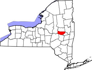 | |
| Towns | ||
| Villages | ||
| CDP | ||
| Hamlets | ||
Coordinates: 42°57′30″N 74°25′01″W / 42.95833°N 74.41694°W