Merstham
| Merstham | |
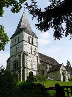 St Katharine's Church |
|
 Merstham |
|
| Area | 9.38 km2 (3.62 sq mi) |
|---|---|
| Population | 8,123 (2011 census)[1] |
| – density | 866/km2 (2,240/sq mi) |
| OS grid reference | TQ295535 |
| Civil parish | n/a |
| District | Reigate and Banstead |
| Shire county | Surrey |
| Region | South East |
| Country | England |
| Sovereign state | United Kingdom |
| Post town | Redhill |
| Postcode district | RH1 |
| Dialling code | 01737 |
| Police | Surrey |
| Fire | Surrey |
| Ambulance | South East Coast |
| EU Parliament | South East England |
| UK Parliament | Reigate |
Coordinates: 51°15′50″N 0°09′11″W / 51.264°N 0.153°W
Merstham /ˈmɜːrstəm/ is a village in the borough of Reigate and Banstead in Surrey, England. It is north of Redhill and is contiguous with it. Part of the North Downs Way runs along the northern boundary of the village. Merstham has community associations, an early medieval church, a football club and an art gallery.
Neighbourhoods
Old Merstham

Old Merstham forms the north and north-west of modern Merstham and is the original village centre. There is a small day school by the railway station, the Rt Art Gallery, two pubs, a few restaurants and a small number of shops.
The art gallery's collection currently (2014) includes original works by Joan Miro and Henry Moore.[2]
The Merstham Estate/New Merstham
A larger housing estate, originally entirely public housing, was built to a geometric layout in the eastern fields. This area has its own parade of shops, the Brook recreation ground, three schools, and a youth/community centre along Radstock Way. Oakley, a small country house, is listed and has Victorian gothic architecture features.[3]
South Merstham
South Merstham is immediately south of both mentioned areas and is made up of mainly Victorian and Edwardian terraces. It provided a workforce for Albury Manor and nearby chalk quarrying and brickworking.[4] Nutfield Road has a long parade of shops.
South Merstham is home to Connevans Limited, who, in April 2016 became holders of the Royal Warrant, by Appointment to Her Majesty Queen Elizabeth II Supplier and Manufacturer of Audio Equipment.
Watercolour
Watercolour is a development, constructed in 2010–11, in South Merstham, close to Mercers Park. Here there is a Tesco Express and a small number of other shops.
History

The area has been settled since pre-Roman times.
The village lay within the Reigate hundred, an Anglo-Saxon administrative division. Its name was recorded in 947 as Mearsætham, which seems to be Anglo-Saxon Mearþ-sǣt-hām = "Homestead near a trap set for martens or weasels".
Merstham appears in Domesday Book of 1086 as Merstan. It was held by Archbishop Lanfranc of Canterbury. Its domesday assets were: 5 hides; 1 church, 1 mill worth 2s 6d, 10 ploughs, 8 acres (3.2 ha) of meadow, woodland and herbage worth 41 hogs. It rendered £12.[5]
The area has long been known for its quarries, and it was to serve these that the village became the terminus of the Croydon, Merstham and Godstone Railway, an extension of the horse-drawn Surrey Iron Railway of 1803, the world's first public railway,[6] albeit only for goods. A small section of the railway is on display at the entrance to Quality Street, Old Merstham. Unfortunately, this section has now been taken.
The first mines at Merstham are recorded almost 1000 years ago in the Domesday Book of 1086, and 'Reigate stone' quarried there was used to build parts of Westminster Abbey, Windsor Castle and Henry VIII's Nonsuch Palace in Surrey.[7]
The use of dynamite was first publicly demonstrated by Alfred Nobel in Price's Grey-lime Stone chalk quarry in July 1868.[8] The site is now partly covered by the route of the M23 motorway just east of where it passes under the Shepherd's Hill bridge.
The original parish church, St Katharine's, dates from around 1220; it replaced an earlier church built c. 1100, although it is believed there has been a church of some form on the site since c. 675 AD.
Merstham's conservation area is centred on its High Street which winds in the village centre to the northwest, forms part of the A23 road and includes many listed buildings; the street with the greatest number, Quality Street, arcs off at a tangent from this curve of the High Street. This was named after J.M. Barrie's play of the same name, in honour of two of the actors in the play, Ellaline Terris and Seymour Hicks, who for a time lived in the 'Old Forge' at the end of the street.[9] 1 High Street partly dates to the 17th century.[10]
The earlier of the two Merstham railway tunnels was the scene of a murder on 24 September 1905. The mutilated body of Mary Sophia Money was found in the tunnel and was first thought to be a case of suicide. On inspection, however, a scarf was found in the victim's throat, and marks on the tunnel wall showed that she had been thrown from a moving train. The crime was never solved, but suspicion rested on her brother, Robert Money.
After World War II, the Merstham Estate was gradually built over a period spanning until the early 1970s.
The old village thus became generally known as Old Merstham, and is occasionally known as Top Merstham.
Rockshaw Road, on the hilltop above the conservation area of Old Merstham, was developed at the very end of the 19th century, and between the World Wars was home to many nationally notable people, among them senior Army and Navy figures, financiers and politicians.[11]

At the junction of Battlebridge Lane and Nutfield Road is All Saints church, the original building of which was destroyed in World War II. Volunteers from the Canadian regiments worked to build a temporary church for the village, which became known as Canada Hall and is used as a village hall and weekly meeting hall for some Merstham branches of the Girl Guides.
Sport and leisure
Merstham has a non-League football club, Merstham F.C., which plays at the Moatside. It also has a cricket club which plays in Fullers league division two.
Merstham Mines, an abandoned mine, is a popular caving destination.[12]
Transport
London buses run to Croydon, Coulsdon, Purley and Redhill town centre. Metrobus operates buses to Reigate, Caterham and Woldingham.
The village is served by Merstham railway station on the Brighton Main Line, with services to London Bridge, London Victoria and Gatwick Airport.
Demography and housing
| Ward | Detached | Semi-detached | Terraced | Flats and apartments | Caravans/temporary/mobile homes/houseboats | Shared between households[1] |
|---|---|---|---|---|---|---|
| Merstham | 549 | 955 | 970 | 744 | 2 | 5 |
The average level of accommodation in the region composed of detached houses was 28%, the average that was apartments was 22.6%.
| Ward | Population | Households | % Owned outright | % Owned with a loan | hectares[1] |
|---|---|---|---|---|---|
| Merstham | 8,123 | 3,225 | 26 | 38 | 938 |
The proportion of households who owned their home outright compares to the regional average of 35.1%. The proportion who owned their home with a loan compares to the regional average of 32.5%. The remaining % is made up of rented dwellings (plus a negligible % of households living rent-free).
See also
References
- 1 2 3 Key Statistics; Quick Statistics: Population Density United Kingdom Census 2011 Office for National Statistics Retrieved 20 December 2013
- ↑ "Art of distinction". Rt Gallery. Retrieved 21 October 2016.
- ↑ Historic England. "Oakley (Grade II) (1241672)". National Heritage List for England. Retrieved 21 October 2016.
- ↑ Malden, H.E., ed. (1911). "Parishes: Merstham". A History of the County of Surrey: Volume 3. Institute of Historical Research. Retrieved 29 December 2013.
- ↑ "DOMESDAY SUDRIE (SURREY)". Archived from the original on 30 October 2007. Retrieved 21 October 2016.
- ↑ "Surrey Iron Railway 200th". Stephenson Locomotive Society. Retrieved 3 October 2012.
- ↑ Hatton, Martin (March 2010). "The Exploitation, Distribution and Use in Buildings of Reigate Stone pt2". Pelobates. Croydon Caving Club (88). Retrieved 21 October 2016.
- ↑ Fant, Keane (2006). Alfred Nobel, a Biography. London: Arcade Publishing. p. 140. ISBN 1559703288.
- ↑ Historic England. "The Old Forge (Grade II) (1188930)". National Heritage List for England. Retrieved 21 October 2016.
- ↑ Historic England. "1, High Street (Grade II) (1294683)". National Heritage List for England. Retrieved 21 October 2016.
- ↑ "Rockshaw Road". rockshawroad.org.uk. Retrieved 21 October 2016.
- ↑ "Caving at Merstham Mines". 3rd Banstead Scout Group. 20 September 2014. Retrieved 21 October 2016.
External links
| Wikimedia Commons has media related to Merstham. |
| Towns, villages, neighbourhoods and hamlets |
|  | ||||||||||||||||||||||||||
|---|---|---|---|---|---|---|---|---|---|---|---|---|---|---|---|---|---|---|---|---|---|---|---|---|---|---|---|---|
| Most notable parks | ||||||||||||||||||||||||||||
| Places of worship | ||||||||||||||||||||||||||||
| Education | ||||||||||||||||||||||||||||
| Transport |
| |||||||||||||||||||||||||||
| Buildings and structures | ||||||||||||||||||||||||||||
| Sport | ||||||||||||||||||||||||||||
| Politics and Administration | ||||||||||||||||||||||||||||
Places listed are articles notable as settlements, arranged by post town The two principal towns are emboldened The M23 motorway follows approximately a boundary and is chiefly included for its regional importance. | ||||||||||||||||||||||||||||