Maysville, West Virginia
| Maysville | |
|---|---|
| Unincorporated community | |
 Maysville  Maysville Location within the state of West Virginia | |
| Coordinates: 39°6′54″N 79°9′53″W / 39.11500°N 79.16472°WCoordinates: 39°6′54″N 79°9′53″W / 39.11500°N 79.16472°W | |
| Country | United States |
| State | West Virginia |
| County | Grant |
| Time zone | Eastern (EST) (UTC-5) |
| • Summer (DST) | EDT (UTC-4) |
| GNIS feature ID | 1555073[1] |
The original county seat of Grant County, Maysville is an unincorporated community on North Fork Lunice Creek in Grant County, West Virginia, United States. The community lies at the eastern approach of Mays Gap in Knobly Mountain along West Virginia Route 42.
The community's name is derived from the local Mays or Mayse family.[2]
References
- ↑ U.S. Geological Survey Geographic Names Information System: Maysville, West Virginia
- ↑ Kenny, Hamill (1945). West Virginia Place Names: Their Origin and Meaning, Including the Nomenclature of the Streams and Mountains. Piedmont, WV: The Place Name Press. p. 407.
Municipalities and communities of Grant County, West Virginia, United States | ||
|---|---|---|
| City | 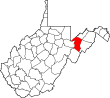 | |
| Town | ||
| Unincorporated communities | ||
| Footnotes | ‡This populated place also has portions in an adjacent county or counties | |
This article is issued from Wikipedia - version of the 8/23/2016. The text is available under the Creative Commons Attribution/Share Alike but additional terms may apply for the media files.