Mattole River
| Mattole River (Mattóal) | |
| stream | |
 Mattole River Estuary | |
| Country | United States |
|---|---|
| State | California |
| Regions | Mendocino County, Humboldt County |
| Cities | Petrolia, Whitethorn, Honeydew |
| Source | King Range |
| - location | 11 mi (18 km) southwest of Redway, California |
| - elevation | 1,780 ft (543 m) |
| - coordinates | 39°59′7″N 123°58′19″W / 39.98528°N 123.97194°W [1] |
| Mouth | Pacific Ocean |
| - location | 4 mi (6 km) west of Petrolia, California |
| - elevation | 0 ft (0 m) |
| - coordinates | 40°18′8″N 124°21′14″W / 40.30222°N 124.35389°WCoordinates: 40°18′8″N 124°21′14″W / 40.30222°N 124.35389°W [1] |
| Length | 62 mi (100 km) |
| Basin | 304 sq mi (787 km2) |
| Discharge | for Petrolia |
| - average | 1,288 cu ft/s (36 m3/s) |
| - max | 90,400 cu ft/s (2,560 m3/s) |
| - min | 11 cu ft/s (0 m3/s) |
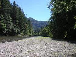
The Mattole River is a river on the north coast of California, that flows northerly, then westerly into the Pacific Ocean. A short section of the river flows through northern Mendocino County, but the vast majority of its 62 miles (100 km) course is through southern Humboldt County. Communities, from north to south, closely associated with the Mattole River include: Petrolia, Honeydew, Ettersburg, Thorn Junction, and Whitethorn. The river enters the ocean at the Mattole Estuary about 4 miles (6.4 km) west-southwest of Petrolia and 10 miles (16 km) south of Cape Mendocino.
History
"Mattole" refers to an Athabaskan Indian people, the Mattole. They historically called themselves Mattóal or bedool, but were called by neighboring Wyott Indians Medol or me'tuul.[2][3] The Mattole lived principally on the Mattole and Bear rivers.[4] This war-like tribe was practically exterminated because of its resistance to white settlers during the Bald Hills War.[2] The local tradition is that Mattole means "clear water".[2]
Watershed
The river and its 74 tributaries drain about 304 square miles (790 km2), including the eastern side of the King Range, and flows through Mattole Valley before emptying into the Pacific Ocean.[5] Although the Mattole River's source is at about 1,780 feet (540 m) elevation, its tributaries originate as high as 4,000 feet (1,200 m) above sea level.[6] The North Fork of the Mattole River enters the river main stem just west of Petrolia. For most of its length, the river is only a 4.2 miles (6.8 km) east of the King Range National Conservation Area. About halfway to the ocean, near Honeydew, California, the river passes by Humboldt Redwoods State Park. There are numerous tributaries and creeks that feed the drainage area. Some of the largest are the Upper North Fork at Honeydew (as opposed to the North Fork at Petrolia), Honeydew, Bear, Rattlesnake, and Oil Creeks.
Ecology and Conservation
The Mattole River has been declared a 303(d) impaired waterbody that flows into a Marine Protected Area (Punta Gorda State Marine Reserve).[7] Areas in the Mattole River watershed are undergoing restoration to restore habitat that was degraded by a combination of early industrial-style timber harvest techniques and associated road construction, naturally erosive geology, and two 100-year floods which occurred in 1955 and 1964. The Mattole River and Range Partnership, consisting of the Mattole Restoration Council, Mattole Salmon Group, and Sanctuary Forest, undertakes this work with the collaboration of watershed landowners and multiple private and agency funders.
The river is used for recreation and agricultural, municipal and industrial water supply. It also provides wildlife habitat including cold freshwater habitat for fish migration and spawning.[8] The Mattole River is home to three salmonid species listed as threatened under the Federal Endangered Species Act: chinook and coho salmon, and steelhead. Coho salmon are additionally listed as threatened under the California State Endangered Species Act. The Mattole Salmon Group counted just three adult Coho salmon in the river in the 2009-2010 winter (and only one redd) which is the lowest number of coho counted since the group began surveys in 2004, and far below the historical estimates of thousands of 17,000-20,000 adults, or even 1950s and 1960s estimates of 8,000 and 5,000, respectively.[9][10] In 2010-2011 ten coho were counted and five redds, but these numbers are still 95% lower than 2006-2007. Each salmon run is on a three-year cycle.[11]
The Mattole Restoration Council, the Mattole Salmon Group, Sanctuary Forest, the Mill Creek Watershed Conservancy, the Upper Mattole River and Forest Cooperative and the Mattole River and Range Partnership fosters the Mattole River habitat restoration work and serves as a model for other communities who wish to work cooperatively to repair anadromous salmonid habitat.[12] Recently the group planned a pilot project to decrease winter runoff and increase summer flows using a beaver dam model. Research done by an ecosystem analyst from the Northwest Fisheries Science Center of NOAA Fisheries shows that salmon smolt production per beaver dam ranges from 527 to 1,174 fish, whereas production in a pool formed by large woody debris is only 6 to 15 fish.[13] This suggests that re-establishment of beaver populations would be 80 times more effective in salmonid recovery efforts than large woody debris placement alone.[14]
The common plant associations within the Mattole include the following: (1) Coast redwood forest (in the southern headwaters), (2) mixed Coast Douglas-fir and hardwood primarily Tanoak and Pacific madrone forest, (3) mixed chaparral, primarily Manzanita, mountain whitethorn, California scrub oak, and Coyote brush, and (4) grasslands. Riparian zones of the Mattole also support Bigleaf maple, Red alder, Fremont cottonwood, Oregon ash, and willow.[15]
 Logging train crossing the Mattole River mouth, circa 1900 |
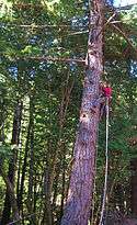 Climbing high to collect native seeds for restoration in the Mattole Watershed |
 Volunteer replants native Douglas Fir on the river |
 Mattole River at Arthur W. Way County Memorial Park |
Parks and Recreation
Arthur W. Way County Memorial Park is on the north bank of and adjacent to the river.
See also
References
- 1 2 U.S. Geological Survey Geographic Names Information System: Mattole River
- 1 2 3 California Place Names – Erwin Gustav Gudde. pp. 195–196. Retrieved 2010-07-07.
- ↑ William Bright (2004). Native American placenames of the United States. University of Oklahoma Press. p. 273. ISBN 978-0-8061-3598-4. Retrieved 2010-07-07.
- ↑ Powers, Stephen (1976) [1877]. Tribes of California. Intro. and Annotations by Robert Heizer. Berkeley and Los Angeles, CA USA: University of California Press. p. 107. ISBN 0-520-03172-5. Retrieved 2010-07-07.
- ↑ Mattole River (PDF) (Report). The Trust for Public Land. Retrieved 2010-01-19.
- ↑ Mattole River and the King Range (PDF) (Report). Save the Redwoods. Retrieved 2010-01-19.
- ↑ "Mattole River" (PDF). California Coastal Commission. Retrieved 2010-07-07.
- ↑ State of California Water Quality Control Plan North Coastal Basin 1B July 1975 p.13
- ↑ Keytra Meyer (February 2010). "The Year Ahead" (pdf). Mattole Salmon Chronicle. p. 2. Retrieved 2010-10-24.
- ↑ John Driscoll (2010-10-24). "Mattole coho on the brink: Groups, agencies to meet on what can be done to spare salmon". The Times-Standard. Retrieved 2010-10-24.
- ↑ Natalie Arroyo (2011-07-07). "Last Call for Coho - An iconic species on the brink in the Mattole Valley and beyond". Humboldt County Journal. Retrieved 2011-09-05.
- ↑ "Mattole Watershed". Trees Foundation. Retrieved 2010-07-07.
- ↑ M. M. Pollock, G. R. Pess, T. J. Beechie (2004). "The Importance of Beaver Ponds to Coho Salmon Production in the Stillaguamish River Basin, Washington, USA" (PDF). North American Journal of Fisheries Management: 749–760. Retrieved 2010-09-09.
- ↑ Tasha McKee (Summer–Fall 2010). "Coho, Beaver Ponds, and Climate Change". Mattole Restoration News. Retrieved 2010-07-21.
- ↑ Hartwell H. Welsh, Garth R. Hodgson, Bret C. Harvey, Maureen E. Roche (2001). "Distribution of Juvenile Coho Salmon in Relation to Water Temperatures in Tributaries of the Mattole River, California" (PDF). North American Journal of Fisheries Management: 464–470. Retrieved 2010-10-24.