Matamoras, Pennsylvania
| Borough of Matamoras | |
| Borough | |
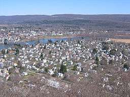 A view of Matamoras from the hills behind the town. Mid-Delaware Bridge connects it to Port Jervis, NY | |
| Country | United States |
|---|---|
| State | Pennsylvania |
| County | Pike |
| Elevation | 427 ft (130.1 m) |
| Coordinates | 41°22′04″N 74°42′07″W / 41.36778°N 74.70194°WCoordinates: 41°22′04″N 74°42′07″W / 41.36778°N 74.70194°W |
| Area | 0.8 sq mi (2.1 km2) |
| - land | 0.7 sq mi (2 km2) |
| - water | 0.1 sq mi (0 km2), 12.5% |
| Population | 2,469 (2010) |
| Density | 3,527.1/sq mi (1,361.8/km2) |
| Incorporated | January 18, 1905 |
| Mayor | Janet Clark |
| Timezone | EST (UTC-5) |
| - summer (DST) | EDT (UTC-4) |
| ZIP code | 18336 |
| Area code | 570 Exchange: 491 |
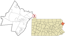 Location in Pike County and the state of Pennsylvania. | |
 Location of Pennsylvania in the United States | |
| Website: www.matamorasborough.com | |
Matamoras is a borough in Pike County, Pennsylvania, United States. The population was 2,469 at the 2010 census. It is the easternmost town in Pennsylvania. Matamoras is part of the New York-Newark-Jersey City, NY-NJ-PA Metropolitan Statistical Area, as well as the larger New York-Newark, NY-NJ-CT-PA Combined Statistical Area.
History
Matamoras was originally part of Westfall Township. Its name came from the Mexican city of Matamoros, which was the first to be occupied by U.S. troops during the Mexican-American War. It was incorporated as a borough on January 18, 1905.[1]
Geography
Matamoras is located at 41°22′4″N 74°42′7″W / 41.36778°N 74.70194°W (41.367818, −74.701831).[2] It is the easternmost point in Pennsylvania. Across the Delaware River are Port Jervis, New York and Montague, New Jersey.
According to the United States Census Bureau, the borough has a total area of 0.8 sq miles, of which 0.7 square miles (1.8 km2) is land and 0.1 square miles (0.26 km2) (11.54%) is water.

 Facing the bridge to Port Jervis, New York on US Routes 6 and 209
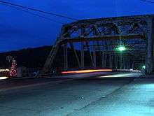 The Mid Delaware Bridge
Demographics
| Historical population | |||
|---|---|---|---|
| Census | Pop. | %± | |
| 1880 | 196 | — | |
| 1910 | 1,388 | — | |
| 1920 | 1,535 | 10.6% | |
| 1930 | 1,784 | 16.2% | |
| 1940 | 1,735 | −2.7% | |
| 1950 | 1,761 | 1.5% | |
| 1960 | 2,087 | 18.5% | |
| 1970 | 2,244 | 7.5% | |
| 1980 | 2,111 | −5.9% | |
| 1990 | 1,934 | −8.4% | |
| 2000 | 2,312 | 19.5% | |
| 2010 | 2,469 | 6.8% | |
| Est. 2015 | 2,383 | [3] | −3.5% |
| Sources:[4][5][6] | |||
As of the census[7] of 2010, there were 2,469 people, 955 households, and 665 families residing in the borough. The population density was 3,527.1/sq mi. There were 1,020 housing units at an average density of 1,457.1 per square mile. The racial makeup of the borough was 93.3% White, 1.4% African American, 0.3% Native American, 1.8% Asian, 0.6% from other races, and 2.7% from two or more races. Hispanic or Latino of any race were 5.5% of the population.
There were 955 households out of which 33.7% had children under the age of 18 living with them, 48.5% were married couples living together, 14.6% had a female householder with no husband present, and 30.4% were non-families. Of all households 24.9% were made up of individuals and 12.4% had someone living alone who was 65 years of age or older. The average household size was 2.59 and the average family size was 3.09.
In the borough the population was spread out with 26.2% under the age of 18, 57.8% from 18 to 64, and 16% who were 65 years of age or older. The median age was 39 years.
The median income for a household in the borough was $37,361, and the median income for a family was $45,917. Males had a median income of $32,875 versus $26,176 for females. The per capita income for the borough was $18,946. About 2.4% of families and 4.0% of the population were below the poverty line, including 1.9% of those under age 18 and 7.4% of those age 65 or over.
Other
References
- ↑ History of Pike County. Pike County, Pennsylvania home page.
- ↑ "US Gazetteer files: 2010, 2000, and 1990". United States Census Bureau. 2011-02-12. Retrieved 2011-04-23.
- ↑ "Annual Estimates of the Resident Population for Incorporated Places: April 1, 2010 to July 1, 2015". Retrieved July 2, 2016.
- ↑ "Census of Population and Housing". U.S. Census Bureau. Retrieved 11 December 2013.
- ↑ "American FactFinder". United States Census Bureau. Retrieved 2008-01-31.
- ↑ "Incorporated Places and Minor Civil Divisions Datasets: Subcounty Resident Population Estimates: April 1, 2010 to July 1, 2012". Population Estimates. U.S. Census Bureau. Retrieved 11 December 2013.
- ↑ "American FactFinder". United States Census Bureau. Retrieved 2011-05-14.
- ↑ http://amystein.com/projects/domesticated/
External links
-
 Media related to Matamoras, Pennsylvania at Wikimedia Commons
 - Borough of Matamoras, official website
- Pike County Dispatch
Municipalities and communities of Pike County, Pennsylvania, United States | ||
|---|---|---|
| Boroughs |  | |
| Townships | ||
| CDPs | ||
| Unincorporated communities | ||
| Footnotes | ‡This populated place also has portions in an adjacent county or counties. | |