Massachusetts Route 7A
| ||||
|---|---|---|---|---|
 | ||||
| Route information | ||||
| Maintained by MassDOT | ||||
| Length: |
25.30 mi[1] (40.72 km) 5.83 mi (9.39 km) without US 7 Northern segment: 2.9 mi. Southern segment: 2.93 mi. | |||
| Existed: | ca. 1961 – present | |||
| Major junctions | ||||
| South end: | Ashley Falls Road in North Canaan, CT | |||
|
| ||||
| North end: |
| |||
| Highway system | ||||
| ||||

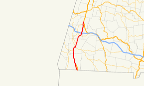
Route 7A is a state highway and alternate to U.S. Route 7 in western Massachusetts. It has two posted segments, with a total length of 5.83 miles (9.38 km). Between these segments, Route 7A is coextensive with Route 7.[1]
Route description
The southern segment begins at the Connecticut border, where the unsigned Connecticut State Road 832 connects Route 7A to its parent route 0.3 miles (0.48 km) south in the town of Canaan. Route 7A runs northward for three miles, through the village of Ashley Falls and crossing the Housatonic River before rejoining its parent route 3 miles (4.8 km) north of the state border.
The route then becomes silent for 22.7 miles (36.5 km), until US 7 reaches the town of Lenox. In Lenox, Route 7A splits with its parent route just south of US 7's junction with US 20. It heads northward, passing the Berkshire Performing Arts Center before sharing a brief, 0.2 miles (0.32 km) concurrency with Route 183. It then turns northward through Lenox Village along Main Street, ending finally at its parent route, one mile northward.
From its southern to northern ends, Route 7A is 25.3 miles (40.7 km) long. Its daylighted sections, however, only add up to approximately 5.6 miles (9.0 km). Both segments follow former alignments of their parent route. The northern segment follows along Route 7's former path, before it was given its bypass route around Lenox Village. The bypass was made as part of a failed attempt to make that route a freeway to Lanesborough.
Major intersections
The entire route is in Berkshire County.
| Location | mi | km | Destinations | Notes | |||
|---|---|---|---|---|---|---|---|
| Sheffield | 0.0 | 0.0 | Ashley Falls Road south | Southern terminus; Connecticut state line | |||
| 3.0 | 4.8 | Southern terminus of silent concurrency with US 7 | |||||
| See US 7 | |||||||
| Lenox | 23.0 | 37.0 | Northern terminus of silent concurrency with US 7 | ||||
| 24.3 | 39.1 | Southern terminus of concurrency with Route 183 | |||||
| 24.5 | 39.4 | Northern terminus of concurrency with Route 183 | |||||
| 25.3 | 40.7 | Northern terminus | |||||
1.000 mi = 1.609 km; 1.000 km = 0.621 mi
| |||||||