Marvel, Colorado
| Marvel, Colorado | |
|---|---|
| Unincorporated community | |
  Location in La Plata County and the state of Colorado | |
| Coordinates: 37°06′45″N 108°07′33″W / 37.11250°N 108.12583°WCoordinates: 37°06′45″N 108°07′33″W / 37.11250°N 108.12583°W | |
| Country |
|
| State |
|
| County | La Plata[1] |
| Elevation[1] | 6,735 ft (2,053 m) |
| Time zone | MST (UTC-7) |
| • Summer (DST) | MDT (UTC-6) |
| ZIP code[2] | 81329 |
| Area code(s) | 970 |
| GNIS feature ID | 0202656 |
Marvel is an unincorporated community and a U.S. Post Office located in La Plata County, Colorado, United States, on the Southern Ute Indian Reservation. While the town lies within the Reservation on most maps, the land within and around the town is owned by private landowners and the actual reservation only starts several miles to the South and East of Marvel. The area was homesteaded in the late-1800s and early-1900s with ranching, farming, and oil extraction being the main economic drivers in the region. The area around Marvel is very dry and the region becomes more and more arid as one travels towards the New Mexico border and further away from the La Plata mountains.
The Marvel Post Office has the ZIP Code 81329.[2]
Geography
Marvel is located at 37°06′45″N 108°07′33″W / 37.11250°N 108.12583°W (37.112420,-108.125896).
References
- 1 2 "US Board on Geographic Names". United States Geological Survey. 2007-10-25. Retrieved 2008-01-31.
- 1 2 "ZIP Code Lookup" (JavaScript/HTML). United States Postal Service. January 2, 2007. Retrieved January 2, 2007.
Municipalities and communities of La Plata County, Colorado, United States | ||
|---|---|---|
| City | 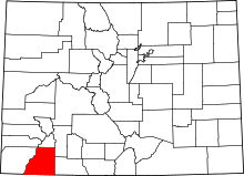 | |
| Towns | ||
| CDP | ||
| Unincorporated communities | ||
| Indian reservation | ||
| Ghost towns |
| |