Maranoa, Queensland
| Maranoa Queensland | |
|---|---|
 | |
| Population | 25,000 (2006)[1] |
| • Density | 0.231/km2 (0.600/sq mi) |
| Area | 108,000 km2 (41,699.0 sq mi) |
| LGA(s) | |
| State electorate(s) | Electoral district of Gregory |
| Federal Division(s) | Division of Maranoa |
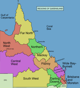
The Maranoa is the name given to an area of southern Queensland. Some refer to the Maranoa as the Western Downs. The Maranoa is an eastern part of the larger, mostly arid South West region of Queensland. To the east is the agricultural region of the Darling Downs and in the west is the dry Channel Country.
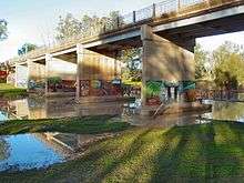
Maranoa River at Mitchell
The traditional agriculture is sheep and cattle grazing suitable for the rangeland landscape and sub-tropical climate of the region. The Balonne River and Maranoa River are the two main catchments in the Maranoa. The Warrego Highway, Carnarvon Highway and Balonne Highway are the major road routes across the region.
See also
References
- ↑ "Regional Planning: Maranoa and Districts". Queensland Government. Archived from the original on 2008-07-20. Retrieved 2008-08-13.
Coordinates: 26°42′15″S 145°52′03″E / 26.70417°S 145.86750°E
This article is issued from Wikipedia - version of the 3/1/2016. The text is available under the Creative Commons Attribution/Share Alike but additional terms may apply for the media files.