Mankin, Texas
Not to be confused with Mankins, Texas.
| Mankin, Texas | |
|---|---|
| Unincorporated community | |
 Mankin  Mankin | |
| Coordinates: 32°11′03″N 96°06′47.4″W / 32.18417°N 96.113167°WCoordinates: 32°11′03″N 96°06′47.4″W / 32.18417°N 96.113167°W | |
| Country | United States |
| State | Texas |
| County | Henderson |
| Time zone | Central (CST) (UTC-6) |
| • Summer (DST) | CDT (UTC-5) |
| Area code(s) | 430, 903 |
| GNIS feature ID | 2034052[1] |
Mankin is an unincorporated community in Henderson County, located in the U.S. state of Texas.[1]
Geography
The village lies nearby the western front of the Cedar Creek Reservoir, on the Texas State Highway 274, between the cities of Tool and Trinidad. It has a cemetery and a church in the east.[2][3]
References
- 1 2 "Mankin, Texas". Geographic Names Information System. United States Geological Survey.
- ↑ Mankin Cemetery (cemeteries-of-tx.com)
- ↑ Mankin Church (texas.hometownlocator.com)
Municipalities and communities of Henderson County, Texas, United States | ||
|---|---|---|
| Cities | 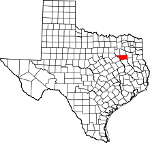 | |
| Towns | ||
| Unincorporated communities | ||
| Ghost towns | ||
| Footnotes | ‡This populated place also has portions in an adjacent county or counties | |
This article is issued from Wikipedia - version of the 7/31/2016. The text is available under the Creative Commons Attribution/Share Alike but additional terms may apply for the media files.