Manitoba Highway 31
| ||||
|---|---|---|---|---|
| Route information | ||||
| Length: | 22 km (14 mi) | |||
| Existed: | 1959 – present | |||
| Major junctions | ||||
| South end: |
| |||
| North end: |
| |||
| Highway system | ||||
| ||||

Provincial Trunk Highway 31 (PTH 31) is a provincial highway in the Canadian province of Manitoba. It is a short highway that runs from PTH 3 to the U.S. border where it becomes North Dakota State Highway 1. The entire highway lies within the Rural Municipality of Pembina.
History
Prior to 1954, Highway 31 was the designation of the route connecting PTH 16 (then known as Highway 4) at Russell to Highway 10 at Swan River via Roblin and Benito.[1] In 1954, the section of PTH 83 between the Trans-Canada Highway and Birtle was constructed and opened to traffic. With this addition, PTH 83 was also extended to Swan River, replacing Highway 31.
PTH 31 was designated to its current route in 1959.[2]
Major intersections
| Division | Location | km | mi | Destinations | Notes |
|---|---|---|---|---|---|
| Pembina | Windygates | 0 | 0.0 | North Dakota state line | |
| | 2 | 1.2 | |||
| | 22 | 14 | PTH 31 ends highway continues as PR 240 | ||
| 1.000 mi = 1.609 km; 1.000 km = 0.621 mi | |||||
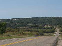
Highway 31 as it passes through the gorge created by the Pembina River
References
- ↑ Manitoba Highway Map (PDF) (Map). Manitoba Minister of Infrastructure and Transportation. 1953. Retrieved March 6, 2015.
- ↑ Manitoba Highway Map (PDF) (Map). Manitoba Minister of Infrastructure and Transportation. 1959. Retrieved March 9, 2015.
This article is issued from Wikipedia - version of the 7/18/2016. The text is available under the Creative Commons Attribution/Share Alike but additional terms may apply for the media files.