Mahnomen, Minnesota
| Mahnomen, Minnesota | |
|---|---|
| City | |
|
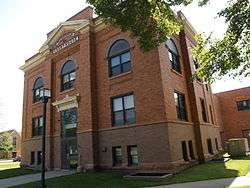
Mahnomen County Courthouse in Mahnomen | |
 Location of the city of Mahnomen within Mahnomen County, Minnesota | |
| Coordinates: 47°18′57″N 95°58′10″W / 47.31583°N 95.96944°W | |
| Country | United States |
| State | Minnesota |
| County | Mahnomen |
| Government | |
| • Mayor | Martin Warnsholz |
| Area[1] | |
| • Total | 1.06 sq mi (2.75 km2) |
| • Land | 1.06 sq mi (2.75 km2) |
| • Water | 0 sq mi (0 km2) |
| Elevation | 1,211 ft (369 m) |
| Population (2010)[2] | |
| • Total | 1,214 |
| • Estimate (2012[3]) | 1,240 |
| • Density | 1,145.3/sq mi (442.2/km2) |
| Time zone | Central (CST) (UTC-6) |
| • Summer (DST) | CDT (UTC-5) |
| ZIP code | 56557 |
| Area code(s) | 218 |
| FIPS code | 27-39392[4] |
| GNIS feature ID | 0647385[5] |
Mahnomen (/məˈnoʊmən/ mə-NOH-mən) is a city in Mahnomen County, Minnesota, United States, along the Wild Rice River. The population was 1,214 at the 2010 census.[6] It is the county seat of Mahnomen County.[7]
U.S. Highway 59 and Minnesota State Highway 200 are two of the main routes in Mahnomen.
History
A post office called Mahnomen has been in operation since 1904.[8] Mahnomen comes from the Ojibwe name for the Wild Rice River.[9]
Geography
According to the United States Census Bureau, the city has a total area of 1.06 square miles (2.75 km2), all of it land.[1]
Demographics
| Historical population | |||
|---|---|---|---|
| Census | Pop. | %± | |
| 1910 | 796 | — | |
| 1920 | 1,076 | 35.2% | |
| 1930 | 989 | −8.1% | |
| 1940 | 1,429 | 44.5% | |
| 1950 | 1,464 | 2.4% | |
| 1960 | 1,462 | −0.1% | |
| 1970 | 1,313 | −10.2% | |
| 1980 | 1,283 | −2.3% | |
| 1990 | 1,154 | −10.1% | |
| 2000 | 1,202 | 4.2% | |
| 2010 | 1,214 | 1.0% | |
| Est. 2015 | 1,222 | [10] | 0.7% |
| U.S. Decennial Census | |||
2010 census
As of the census[2] of 2010, there were 1,214 people, 529 households, and 293 families residing in the city. The population density was 1,145.3 inhabitants per square mile (442.2/km2). There were 582 housing units at an average density of 549.1 per square mile (212.0/km2). The racial makeup of the city was 59.3% White, 0.2% African American, 31.2% Native American, 0.1% Asian, and 9.2% from two or more races. Hispanic or Latino of any race were 1.8% of the population.
There were 529 households of which 24.8% had children under the age of 18 living with them, 32.3% were married couples living together, 14.7% had a female householder with no husband present, 8.3% had a male householder with no wife present, and 44.6% were non-families. 36.5% of all households were made up of individuals and 16.5% had someone living alone who was 65 years of age or older. The average household size was 2.20 and the average family size was 2.81.
The median age in the city was 44.8 years. 22.4% of residents were under the age of 18; 6.8% were between the ages of 18 and 24; 21.1% were from 25 to 44; 28% were from 45 to 64; and 21.7% were 65 years of age or older. The gender makeup of the city was 49.3% male and 50.7% female.
2000 census
As of the census[4] of 2000, there were 1,202 people, 532 households, and 311 families residing in the city. The population density was 1,252.9 people per square mile (483.4/km²). There were 576 housing units at an average density of 600.4 per square mile (231.7/km²). The racial makeup of the city was 74.29% White, 0.08% African American, 16.06% Native American, and 9.57% from two or more races. Hispanic or Latino of any race were 1.08% of the population.
There were 532 households out of which 25.9% had children under the age of 18 living with them, 42.5% were married couples living together, 12.6% had a female householder with no husband present, and 41.4% were non-families. 37.4% of all households were made up of individuals and 25.6% had someone living alone who was 65 years of age or older. The average household size was 2.16 and the average family size was 2.85.
In the city the population was spread out with 23.3% under the age of 18, 5.0% from 18 to 24, 21.9% from 25 to 44, 22.7% from 45 to 64, and 27.1% who were 65 years of age or older. The median age was 45 years. For every 100 females there were 87.8 males. For every 100 females age 18 and over, there were 77.0 males.
The median income for a household in the city was $26,000, and the median income for a family was $37,500. Males had a median income of $24,479 versus $21,625 for females. The per capita income for the city was $14,538. About 9.8% of families and 14.0% of the population were below the poverty line, including 16.1% of those under age 18 and 19.5% of those age 65 or over.
Notable people
- Nicholas Spaeth, North Dakota Attorney General, was born in Mahnomen.[11]
References
- 1 2 "US Gazetteer files 2010". United States Census Bureau. Retrieved 2012-11-13.
- 1 2 "American FactFinder". United States Census Bureau. Retrieved 2012-11-13.
- ↑ "Population Estimates". United States Census Bureau. Retrieved 2013-05-28.
- 1 2 "American FactFinder". United States Census Bureau. Retrieved 2008-01-31.
- ↑ "US Board on Geographic Names". United States Geological Survey. 2007-10-25. Retrieved 2008-01-31.
- ↑ "2010 Census Redistricting Data (Public Law 94-171) Summary File". American FactFinder. U.S. Census Bureau, 2010 Census. Retrieved 23 April 2011.
- ↑ "Find a County". National Association of Counties. Retrieved 2011-06-07.
- ↑ "County". Jim Forte Postal History. Retrieved 20 July 2015.
- ↑ Upham, Warren (1920). Minnesota Geographic Names: Their Origin and Historic Significance. Minnesota Historical Society. p. 323.
- ↑ "Annual Estimates of the Resident Population for Incorporated Places: April 1, 2010 to July 1, 2015". Retrieved July 2, 2016.
- ↑ North Supreme Court News-Nicholas Spaeth
External links
Municipalities and communities of Mahnomen County, Minnesota, United States | ||
|---|---|---|
| Cities | 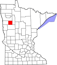 | |
| Townships | ||
| CDPs | ||
| Unincorporated community | ||
| Indian reservations | ||
| Footnotes | ‡This populated place also has portions in an adjacent county or counties | |
Coordinates: 47°18′55″N 95°58′07″W / 47.31528°N 95.96861°W