Magnolia, Mississippi
| Magnolia, Mississippi | |
|---|---|
| City | |
 Location of Magnolia, Mississippi | |
 Magnolia, Mississippi Location in the United States | |
| Coordinates: 31°8′57″N 90°27′41″W / 31.14917°N 90.46139°WCoordinates: 31°8′57″N 90°27′41″W / 31.14917°N 90.46139°W | |
| Country | United States |
| State | Mississippi |
| County | Pike |
| Government | |
| • Mayor | Anthony Witherspoon |
| Area | |
| • Total | 3.3 sq mi (8.5 km2) |
| • Land | 3.2 sq mi (8.4 km2) |
| • Water | 0.1 sq mi (0.1 km2) |
| Elevation | 305 ft (93 m) |
| Population (2010) | |
| • Total | 2,420 |
| • Density | 639.5/sq mi (246.9/km2) |
| Time zone | Central (CST) (UTC-6) |
| • Summer (DST) | CDT (UTC-5) |
| ZIP code | 39652 |
| Area code(s) | 601 |
| FIPS code | 28-44680 |
| GNIS feature ID | 0673065 |
Magnolia is a city in Pike County, Mississippi. The population was 2,420 at the 2010 census. It is the county seat of Pike County,[1] which lies within the McComb, Mississippi Micropolitan Statistical Area.
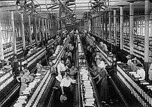
History
.jpg)
Magnolia was founded in 1856 by Ansel H. Prewett, a local civic leader and cotton planter. Knowing that the approaching New Orleans, Jackson, and Great Northern Railroad (now the Illinois Central Railroad) would need a station for water and fuel, Prewett sold a right-of-way to the railroad company – for one dollar, according to legend – and divided a section of his plantation into town lots, which he sold to investors. Prewett, while serving as temporary sheriff of Pike County, was killed by outlaws in the early 1870s escorting a prisoner on the very railroad that made Magnolia a viable community.[2]
Magnolia grew rapidly in the 1860s, and in the late nineteenth century Magnolia served as a popular small-town resort for wealthy New Orleanians, who took trains north from New Orleans to enjoy Magnolia's fresh air and sparkling creeks. At one time early Magnolia boasted an opera house, skating rink, and several hotels that catered largely to these tourists.
In 1860 Magnolia's first newspaper, the "Grand Trunk Magnolian", was established by John Waddill. It did not last the war and was succeeded by the establishment of the "Magnolia Gazette" by J.D. Burke in 1872. The "Magnolia Herald" was established by Luke W. Conerly in 1875 and he continued as its proprietor and editor until 1878.[3]
Geography
Magnolia is located at 31°8′57″N 90°27′41″W / 31.14917°N 90.46139°W (31.149272, -90.461332).[4]
According to the United States Census Bureau, the city has a total area of 3.3 square miles (8.5 km2), of which 3.2 square miles (8.3 km2) is land and 0.1 square miles (0.26 km2) (1.52%) is water.
Demographics
| Historical population | |||
|---|---|---|---|
| Census | Pop. | %± | |
| 1880 | 567 | — | |
| 1890 | 676 | 19.2% | |
| 1900 | 1,088 | 60.9% | |
| 1910 | 1,823 | 67.6% | |
| 1920 | 2,012 | 10.4% | |
| 1930 | 1,660 | −17.5% | |
| 1940 | 2,125 | 28.0% | |
| 1950 | 1,984 | −6.6% | |
| 1960 | 2,083 | 5.0% | |
| 1970 | 1,970 | −5.4% | |
| 1980 | 2,461 | 24.9% | |
| 1990 | 2,245 | −8.8% | |
| 2000 | 2,071 | −7.8% | |
| 2010 | 2,420 | 16.9% | |
| Est. 2015 | 2,371 | [5] | −2.0% |
As of the census[7] of 2000, there were 2,071 people, 749 households, and 515 families residing in the city. The population density was 639.5 people per square mile (246.8/km²). There were 898 housing units at an average density of 277.3 per square mile (107.0/km²). The racial makeup of the city was 44.42% White, 53.84% African American, 0.43% Native American, 0.34% Asian, 0.29% from other races, and 0.68% from two or more races. Hispanic or Latino of any race were 1.16% of the population.
There were 749 households out of which 31.2% had children under the age of 18 living with them, 38.1% were married couples living together, 24.7% had a female householder with no husband present, and 31.2% were non-families. 28.6% of all households were made up of individuals and 15.1% had someone living alone who was 65 years of age or older. The average household size was 2.54 and the average family size was 3.08.
In the city the population was spread out with 24.4% under the age of 18, 12.3% from 18 to 24, 25.7% from 25 to 44, 22.2% from 45 to 64, and 15.4% who were 65 years of age or older. The median age was 36 years. For every 100 females there were 97.1 males. For every 100 females age 18 and over, there were 94.5 males.
The median income for a household in the city was $21,190, and the median income for a family was $25,069. Males had a median income of $21,991 versus $18,839 for females. The per capita income for the city was $12,426. About 18.0% of families and 22.5% of the population were below the poverty line, including 30.1% of those under age 18 and 23.2% of those age 65 or over.
Notable people
- Dorothy F. Bainton, distinguished pathologist, author, and educator. Author of 113 articles and 27 book chapters. Vice Chancellor of University of California, San Francisco.[8]
- Jerry Butler, award-winning artist, author and educator. Chair of the Art Department at Madison Area Technical College [Wisconsin].[9]
- Walter W. Crawford, MD (b. 21 Mar1872) known as the "Surgical Dean of Mississippi. The leading figure in the successful effort to secure the foundation of Camp Shelby near Hattiesburg in 1917. Organized the Southern Medical Association, and was president of the Mississippi Medical Association and the Mississippi Board of Health. Was a Lt. Col. in the US Army Medical Corps in France during WWI.
- Prentiss Barnes (12 Apr 1925-1 Oct 2006) bass singer in the doo-wop group, The Moonglows. Inducted into the Rock and Roll Hall of Fame in 2000.
- Vernall Varnado (b. 13 Dec 1949) father of Snoop Dogg (Calvin Broadus), American rapper, singer-songwriter, and actor.
Transportation
Highways
Air
- McComb-Pike County Airport
Services
The City of Magnolia is served by the South Pike School District. The town has one public library. The nearest hospital is Beacham Memorial Hospital.
Recreation
Climate
The climate in this area is characterized by hot, humid summers and generally mild to cool winters. According to the Köppen Climate Classification system, Magnolia has a humid subtropical climate, abbreviated "Cfa" on climate maps.[10]
References
- ↑ "Find a County". National Association of Counties. Retrieved 2011-06-07.
- ↑ Martha Lacy Hall, An Historical Sketch of Magnolia, Mississippi: Centennial Celebration, Magnolia, Mississippi, 1856-1956. Magnolia, Mississippi: W. M. Lacy, 1956.
- ↑ Pike County Mississippi 1798-1876 Pioneer Families and Confederate Soldiers by Luke W. Conerly 1909
- ↑ "US Gazetteer files: 2010, 2000, and 1990". United States Census Bureau. 2011-02-12. Retrieved 2011-04-23.
- ↑ "Annual Estimates of the Resident Population for Incorporated Places: April 1, 2010 to July 1, 2015". Retrieved July 2, 2016.
- ↑ "Census of Population and Housing". Census.gov. Retrieved June 4, 2015.
- ↑ "American FactFinder". United States Census Bureau. Retrieved 2008-01-31.
- ↑
- ↑
- ↑ Climate Summary for Magnolia, Mississippi
External links
Municipalities and communities of Pike County, Mississippi, United States | ||
|---|---|---|
| Cities | 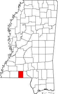 | |
| Towns | ||
| Unincorporated communities | ||