Magnae Dobunnorum
Magnae, sometimes Magnae Dobunnorum (Latin for "The Greats of the Dobunni") to distinguish it from the Magnae of the Carvetii in northern Britain,[1] was a Romano-British town and an important market centre for the British Dobunni tribe, located near modern-day Kenchester in Herefordshire, England. The town was shaped as an irregular hexagon, with a single main street along the line of the main Roman Road running east-west through the area, and an irregular pattern of side streets with tightly packed buildings leading off it.[2]
Name
The Roman town is securely identified with the "Magnis" which appears both in the Antonine Itinerary and Ravenna Cosmography.[3] The town is today sometimes referred to under the name "Magna".[4] However, the town was not a colonia, nor a tribal capital,[5] and Rivet and Smith derive the name from the Celtic word maen meaning 'stone' or 'rock'.[6] The name may apply to the hills visible to the north of Kenchester.[7]
History
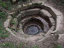
The ruins of a Roman temple possibly associated with a high-status Roman villa, which may have connections to Magnae, lie inside the Weir Garden by the River Wye. There is an octagonal cistern filled by a spring, and a ruined buttress by the river. These are the highest standing Roman ruins in Herefordshire.[8][9]
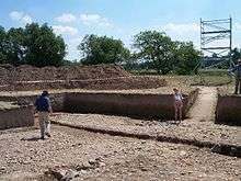
Earthen defences have been found dating from the 2nd century, with later stone defences being built by the 4th century and occupation likely to have continued into the 5th century.[10]
In the Sub-Roman Period, Cair Magon formed a citadel of the British kingdom of Pengwern.
After Pengwern was overrun, the town was the base of the Mercian subkingdom of Magonsaete.[11]
References
- ↑ Both names are sometimes also given as Magnis, the form under which it appears in the Antonine Itinerary owing to Latin's declensions. It is also sometimes misspelled as singular Magna.
- ↑ "MAGNIS Romano-British Town". www.roman-britain.org. Togodumnus. Retrieved 2009-06-07.
- ↑ Burnham; Wacher, J. S. (1990). The Small Towns of Roman Britain. University of California Press. p. 76. ISBN 0520073037.
- ↑ Darvill, Timothy; Stamper, Paul; Timby, Jane (2002). England: An Oxford Archaeological Guide to Sites from Earliest Times to AD 1600. Oxford University Press. p. 204. ISBN 0192841017.
- ↑ Durant, Gladys May (1957). Journey into Roman Britain. W. W. Norton. p. 183.
- ↑ Rivet, A.L.F; Smith, Colin (1979). The Place-Names of Roman Britain. Batsford. p. 407. ISBN 0713420774.
- ↑ Hines, John (2003). The Anglo-Saxons from the Migration Period to the Eighth Century: An Ethnographic Perspective. Boydell Press. p. 74. ISBN 1843830345.
- ↑ "Suspected Romano-British Temple, The Weir Gardens". www.Roman-Britain.org. Retrieved 2013-04-04.
- ↑ "Roman Riverside Building Complex, The Weir Garden". Herefordshire Monuments Search. Retrieved 2013-04-04.
- ↑ "MAGNIS". Pastscape - National Monuments Record. English Heritage. Retrieved 2009-05-07.
- ↑ Kirby, D. P. (2000). The earliest English kings. Routledge. p. 9. ISBN 0-415-24210-X. Retrieved 2009-06-07.
Coordinates: 52°04′52″N 2°49′05″W / 52.081°N 2.818°W