Magdalena, Intibucá
| Magdalena | |
|---|---|
| Nickname(s): Magda | |
 Magdalena Location in Honduras | |
| Coordinates: 13°56′02.60″N 88°22′36.70″W / 13.9340556°N 88.3768611°W | |
| Country | Honduras |
| Department | Intibucá |
| Municipality | Magdalena |
| Foundation | 26 October 1861 |
| Government | |
| • Mayor | Mauricio Aguilar |
| Area | |
| • Total | 42 km2 (16 sq mi) |
| Elevation | 294 m (965 ft) |
| Population (2015) | |
| • Total | 4,422 |
| • Density | 110/km2 (270/sq mi) |
| Postal Code | 1008 |
| Website |
vivemagdalena |
Magdalena (Spanish pronunciation: [maɣðaˈlena]) is a municipality in the Honduran department of Intibucá, 86 km are located to the south of the city of The Hope, Intibucá, and to 280 km to the west of Tegucigalpa.
The municipality is constituted for, seven villages and thirty three hamlets, the municipal head-board is divided in seven neighbourhoods.
History
It is not easy to quarrel who were the first settlers of this municipality, wherefrom nor came and in that time they were established; since Camasca and Colomoncagua's peoples(villages) indigenous already existed in the last years of the 18th century. According to Hector P. Nolasco, the eldest and most experienced historian in history of the municipality of sponge-cake, where at present it is A Sponge-cake they were household tasks that were concerning(belonged) to Camasca's party(game) wherefrom they were disintegrated to form a new municipality.
For documents ancient, previous to his(its) foundation it is known that at the beginning of the 17th century was measured and qualified " Estate of the Sponge-cake ", which was measuring seven cavalries, was re-measured on July, seven, 1740, by request of Indian Marcos Díaz Chief of Camasca ".
According to a leaflet edited by the notable teacher Maria Trinidad of the Leader, this he (she) was saying that Magdalena's municipality I found on 15 October 1821; this information was re-dug by her (it) so (then, since) don Florentín of the Leader, grandfather of the teacher exercised the cargo of municipal secretary for several years of the 19th century and the beginning of the 20th century, since in these years the municipal file had not suffered ruin and they were finding in many ancient documents and of great importance; but according to other opposing information later it is known that the date of creation was on 26 October 1861. This municipality I form for the union of the household tasks The Magdalena, San Blas, The Trinidad, The Charity, part(report) of the household tasks The Old Negress, San Paul Tenamera and the village of San Juan Troncoso.
The constitutional mayor and chief of Camasca's district I deposit this population on 21 June 1843 who proceeded to do the señalamiento of the courses and milestones of the demarcation of Magdalena's municipality.
This municipality I disintegrate of Camasca, and Magdalena's municipality(Magdalena's corporated town) seeing that this people(village) was lacking common lands in order that his(its,her) inhabitants were employed freely at the agriculture, they had to do request to the supreme government in order that of the common lands of Camasca's municipality it(he,she) was yielding a part to increase this way his(its) territory. In 1870 being a president of the republic the governing general Jose Maria Medina and Rosa Muñoz of the department of Thanks to that this municipality was concerning(belonged).
The supreme government in view of the just request of Magdalena's people(village), I send the land-surveyor Juan Bautista Collart, in order that of Camasca's common lands it(he,she) was measuring five cavalries of area those that spent(passed) to be common lands of this municipality.
The measure in reference was practised on the 14th, 15, 16, 17 and 18 October 1870. The drawers of rope(string) were Doroteo and Teodosio Ramos, witnesses Valentín Días y Olayo Clear neighbouring(similar) of Holy Shiny, book-keepers were Francisco Rodríguez and Genaro Juárez, of this neighbourhood. The rope(string) that I use average 50 Castilian rods. At present with the utilisation of the most modern devices and technologies(skills) of measurement it is known that the municipality measures 39.7 Km2.
Magdalena's neighbourhoods
- El Castaño
- La Cultura
- El Centro
- El Recibimiento
- Barrio Abajo
- El Llano
- Buenos Aires
Capital: La Esperanza | ||
| Municipalities | 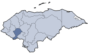 | |
Coordinates: 13°55′59.61″N 88°22′32.26″W / 13.9332250°N 88.3756278°W