Madison, Maryland
| Madison, Maryland | |
|---|---|
| Census-designated place | |
 Madison  Madison Location in Maryland | |
| Coordinates: 38°30′25″N 76°13′19″W / 38.50694°N 76.22194°WCoordinates: 38°30′25″N 76°13′19″W / 38.50694°N 76.22194°W | |
| Country | United States |
| State | Maryland |
| County | Dorchester |
| Area | |
| • Total | 3.2 sq mi (8.4 km2) |
| • Land | 3.2 sq mi (8.3 km2) |
| • Water | 0.04 sq mi (0.1 km2) |
| Elevation | 4 ft (1 m) |
| Population (2010) | |
| • Total | 204 |
| • Density | 64/sq mi (24.6/km2) |
| Time zone | Eastern (EST) (UTC-5) |
| • Summer (DST) | EDT (UTC-4) |
| ZIP codes | 21648, 21677 |
| Area code(s) | 410, 443, and 667 |
| FIPS code | 24-49700 |
| GNIS feature ID | 585655 |
Madison is an unincorporated community and census-designated place (CDP) in Dorchester County, Maryland, United States.[1] The population was 204 at the 2010 census.[2]
Geography
Madison is located in western Dorchester County, at the south end of Madison Bay, an arm of the Little Choptank River and part of the Chesapeake Bay estuary system. Maryland Route 16 passes through the community, leading northeast 10 miles (16 km) to Cambridge, the county seat, and southwest 5 miles (8 km) to Taylors Island.
According to the United States Census Bureau, the Madison CDP has a total area of 3.2 square miles (8.4 km2), of which 3.2 square miles (8.3 km2) is land and 0.04 square miles (0.1 km2), or 1.26%, is water.[2]
References
- ↑ U.S. Geological Survey Geographic Names Information System: Madison, Maryland
- 1 2 "Geographic Identifiers: 2010 Demographic Profile Data (G001): Madison CDP, Maryland". U.S. Census Bureau, American Factfinder. Retrieved October 29, 2015.
Municipalities and communities of Dorchester County, Maryland, United States | ||
|---|---|---|
| City | 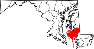 | |
| Towns | ||
| CDP | ||
| Other communities | ||
| Footnotes | ‡This populated place also has portions in an adjacent county or counties | |
This article is issued from Wikipedia - version of the 10/29/2016. The text is available under the Creative Commons Attribution/Share Alike but additional terms may apply for the media files.