Highway M01 (Ukraine)
| |
|---|---|
| Автошлях M01 | |
.png) | |
| Route information | |
| Length: |
205.6 km (127.8 mi) 224.4 km (139.4 mi) with access roads |
| Length: |
205.6 km (127.8 mi) 224.4 km (139.4 mi) with access roads |
| South end: |
(Kiev) |
| Major junctions: |
(Kipti) |
| North end: |
(Novi Yarylovychi) |
| Length: |
91.0 km (56.5 mi) 96 km (59.7 mi) with access roads |
| South end: |
(Kiev) |
| North end: |
(Kipti) |
| Location | |
| Regions: | Kiev City, Kiev Oblast, Chernihiv Oblast |
| Highway system | |
| Roads in Ukraine | |
M01 is a Ukraine international highway (M-highway) that stretches from the state capital, Kiev, to the northern border with Belarus.[1]
Together with the M05 it is a part of the European routes E95 (Saint Petersburg – Kiev – Odessa … Samsun – Merzifon) and the Trans-European transportation corridor IX. Also together with the M02 it is part of E101 (Kiev – Moscow).[2]
Route / Junctions
.jpg)
![]() is 205.6 km (127.8 mi) long going in the north-south direction. Its southern end is in Kiev at intersection of Academician Hlushkov Parkway (Akademika Hlushkova Avenue) and Academician Zabolotny Parkway (Akademika Zabolotnoho Avenue).
is 205.6 km (127.8 mi) long going in the north-south direction. Its southern end is in Kiev at intersection of Academician Hlushkov Parkway (Akademika Hlushkova Avenue) and Academician Zabolotny Parkway (Akademika Zabolotnoho Avenue).

The intersection connects ![]() with
with ![]() which combine route
which combine route ![]() within Ukraine. Coming through the city of Kiev it crosses Dnipro at Paton's bridge and continuing towards Brovary Parkway by Voziednannya Parkway. Coming from there the highway goes around Brovary (one branch goes through the city and rejoins the route), then goes around Kozelets crossing a river and continuing north. Not far north from Kozelets
within Ukraine. Coming through the city of Kiev it crosses Dnipro at Paton's bridge and continuing towards Brovary Parkway by Voziednannya Parkway. Coming from there the highway goes around Brovary (one branch goes through the city and rejoins the route), then goes around Kozelets crossing a river and continuing north. Not far north from Kozelets ![]() splits north of Kipti traveling east by Highway
splits north of Kipti traveling east by Highway ![]() , while
, while ![]() continues north towards Chernihiv. Near village of Yahidne, south of Chernihiv,
continues north towards Chernihiv. Near village of Yahidne, south of Chernihiv, ![]() spurs with one branch and
spurs with one branch and ![]() going west and then north around Chernihiv crossing another river; and second branch continues without deviation through the city, crossing the same river as the main route and after 13.7 km rejoins it north of Chernihiv. Shortly after Chernihiv
going west and then north around Chernihiv crossing another river; and second branch continues without deviation through the city, crossing the same river as the main route and after 13.7 km rejoins it north of Chernihiv. Shortly after Chernihiv ![]() goes right through the village of Ripky with numerous private homes located close to the road. After Ripky the next important settlement is Novi Yarylovychi that is located just south of the border with Belarus. The border, however, is located about six miles north of the settlement past the village of Skytok.
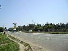
The section from Kiev to Chernihiv is a dual carriageway, from Chernihiv it continues as a single carriageway.
goes right through the village of Ripky with numerous private homes located close to the road. After Ripky the next important settlement is Novi Yarylovychi that is located just south of the border with Belarus. The border, however, is located about six miles north of the settlement past the village of Skytok.
The section from Kiev to Chernihiv is a dual carriageway, from Chernihiv it continues as a single carriageway.
| Highway M01 | |||
| Marker | Main settlements | Notes | Highway Interchanges |
|---|---|---|---|
| 0 km | Kiev | ||
| 22 km | Brovary | Bypass | |
| 91 km | Kipti | ||
| 128 km | Chernihiv | Bypass | |
| 164 km | Ripky | ||
| 206 km | Novi Yarylovychi / Border (Belarus) | ||
Repairs
Repairs to the highway in Ukraine have started in 2007 and are planned to be finished before UEFA Euro 2012.[3]
See also
References
External links
- Highways in Ukraine — Автодороги Украины.(russian lang.) Information about highways, motorways, regional roads in Ukraine.
- International Roads in Ukraine in Russian
- European Roads in Russian
- List of automobile roads, Declaration of the Cabinet of Ministers of Ukraine
| E-roads in Ukraine | ||
|---|---|---|
| International | ||
| National | ||
| Regional |
| |
| ||