Lynnville, Kentucky
| Lynnville | |
|---|---|
| Unincorporated community | |
|
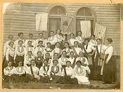
Rebecca Lodge, Lynnville, KY 1909 | |
 Lynnville Lynnville's position in Kentucky. | |
| Coordinates: 36°33′37″N 88°34′09″W / 36.56028°N 88.56917°WCoordinates: 36°33′37″N 88°34′09″W / 36.56028°N 88.56917°W | |
| Country |
|
| State |
|
| County | Graves |
| Elevation | 169 m (554 ft) |
| Time zone | Central (CST) (UTC-6) |
| • Summer (DST) | CDT (UTC-5) |
| GNIS feature ID | 497387 |
| U.S. Geological Survey Geographic Names Information System: Lynnville, Kentucky | |
Lynnville is an unincorporated community in Graves County, Kentucky, United States.[1] On April 25, 2011, an EF1 tornado causing some damage, part of the April 25–28, 2011 tornado outbreak, traveled from Martin, Tennessee to Lynnville.[2]
References
- ↑ "Feature Detail Report for: Lynnville, Kentucky." USGS. U.S. Geological Survey Geographic Names Information System: Lynnville, Kentucky Retrieved May 11, 2011.
- ↑ http://www.crh.noaa.gov/images/pah/may2011flooding/tornado%20track%20map%20april%2019-27.jpg National Weather Service Paducah (KY) Office Map
Municipalities and communities of Graves County, Kentucky, United States | ||
|---|---|---|
| Cities | 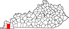 | |
| CDPs | ||
| Unincorporated communities | ||
| Footnotes | ‡This populated place also has portions in an adjacent county or counties | |
This article is issued from Wikipedia - version of the 3/29/2016. The text is available under the Creative Commons Attribution/Share Alike but additional terms may apply for the media files.