Lumberton, Mississippi
| Lumberton, Mississippi | |
|---|---|
| City | |
|
The U.S. Post Office in Lumberton, Mississippi | |
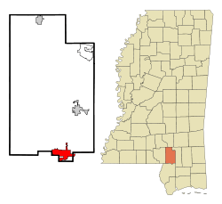 Location of Lumberton, Mississippi | |
 Lumberton, Mississippi Location in the United States | |
| Coordinates: 31°0′14″N 89°27′13″W / 31.00389°N 89.45361°WCoordinates: 31°0′14″N 89°27′13″W / 31.00389°N 89.45361°W | |
| Country | United States |
| State | Mississippi |
| Counties | Lamar, Pearl River |
| Government | |
| • Mayor | Ben Winston |
| Area | |
| • Total | 7.3 sq mi (18.9 km2) |
| • Land | 7.3 sq mi (18.8 km2) |
| • Water | 0.0 sq mi (0.1 km2) |
| Elevation | 295 ft (90 m) |
| Population (2000) | |
| • Total | 2,228 |
| • Density | 307.1/sq mi (118.6/km2) |
| Time zone | Central (CST) (UTC-6) |
| • Summer (DST) | CDT (UTC-5) |
| ZIP code | 39455 |
| Area code(s) | 601 |
| FIPS code | 28-42640 |
| GNIS feature ID | 0693845 |

Lumberton is a city in Lamar and Pearl River counties, Mississippi. It is part of the Hattiesburg, Mississippi Metropolitan Statistical Area. The population was 2,228 at the 2000 census.
History
The city was named for the local lumber industry.[1]
Geography
Lumberton is located at 31°0′14″N 89°27′13″W / 31.00389°N 89.45361°W (31.003888, -89.453544).[2] Most of the city is in Lamar County, with a small portion extending east into adjacent Pearl River County.[3] In the 2000 census, 2,200 of the city's 2,228 residents (98.7%) lived in Lamar County and 28 (1.3%) in Pearl River County.[4]
According to the United States Census Bureau, the city has a total area of 7.3 square miles (18.9 km²), of which 7.3 square miles (18.8 km²) is land and 0.04 square mile (0.1 km²) (0.27%) is water.
Demographics
| Historical population | |||
|---|---|---|---|
| Census | Pop. | %± | |
| 1900 | 1,509 | — | |
| 1910 | 2,122 | 40.6% | |
| 1920 | 2,192 | 3.3% | |
| 1930 | 2,374 | 8.3% | |
| 1940 | 1,485 | −37.4% | |
| 1950 | 1,803 | 21.4% | |
| 1960 | 2,108 | 16.9% | |
| 1970 | 2,084 | −1.1% | |
| 1980 | 2,217 | 6.4% | |
| 1990 | 2,121 | −4.3% | |
| 2000 | 2,228 | 5.0% | |
| 2010 | 2,086 | −6.4% | |
| Est. 2015 | 2,223 | [5] | 6.6% |
As of the census[7] of 2000, there were 2,228 people, 829 households, and 602 families residing in the city. The population density was 307.1 people per square mile (118.5/km²). There were 920 housing units at an average density of 126.8 per square mile (48.9/km²). The racial makeup of the city was 45.56% White, 53.64% African American, 0.27% Native American, 0.09% Asian, 0.04% from other races, and 0.40% from two or more races. Hispanic or Latino of any race were 0.45% of the population.
There were 829 households out of which 36.9% had children under the age of 18 living with them, 42.2% were married couples living together, 25.8% had a female householder with no husband present, and 27.3% were non-families. 25.8% of all households were made up of individuals and 10.4% had someone living alone who was 65 years of age or older. The average household size was 2.66 and the average family size was 3.17.
In the city the population was spread out with 31.7% under the age of 18, 9.4% from 18 to 24, 26.5% from 25 to 44, 20.2% from 45 to 64, and 12.2% who were 65 years of age or older. The median age was 31 years. For every 100 females there were 85.4 males. For every 100 females age 18 and over, there were 82.8 males.
The median income for a household in the city was $23,178, and the median income for a family was $26,603. Males had a median income of $26,563 versus $16,821 for females. The per capita income for the city was $11,384. About 23.2% of families and 30.8% of the population were below the poverty line, including 42.7% of those under age 18 and 29.3% of those age 65 or over.
Education
The City of Lumberton is served by the Lumberton Public School District.
Notable people
- James H. Street, journalist, minister, and writer of Southern historical novels.
- Richard Alvin Tonry, Louisiana politician.
- Heber Austin Ladner, former longest serving Secretary of State of Mississippi.
References
- ↑ Gannett, Henry (1905). The Origin of Certain Place Names in the United States. U.S. Government Printing Office. p. 192.
- ↑ "US Gazetteer files: 2010, 2000, and 1990". United States Census Bureau. 2011-02-12. Retrieved 2011-04-23.
- ↑ American Factfinder Reference Map
- ↑ "Subcounty population estimates: Mississippi 2000-2006" (CSV). United States Census Bureau, Population Division. 2007-06-28. Retrieved 2007-07-21.
- ↑ "Annual Estimates of the Resident Population for Incorporated Places: April 1, 2010 to July 1, 2015". Retrieved July 2, 2016.
- ↑ "Census of Population and Housing". Census.gov. Retrieved June 4, 2015.
- ↑ "American FactFinder". United States Census Bureau. Retrieved 2008-01-31.
External links
| Wikimedia Commons has media related to Lumberton, Mississippi. |
Municipalities and communities of Lamar County, Mississippi, United States | ||
|---|---|---|
| Cities | 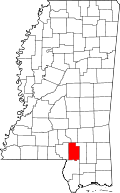 | |
| Towns | ||
| CDPs | ||
| Unincorporated communities | ||
| Footnotes | ‡This populated place also has portions in an adjacent county or counties | |
Municipalities and communities of Pearl River County, Mississippi, United States | ||
|---|---|---|
| Cities |  | |
| CDPs |
| |
| Other unincorporated communities | ||
| Footnotes | ‡This populated place also has portions in an adjacent county or counties | |