Louisiana Highway 18
| ||||
|---|---|---|---|---|
 | ||||
| Route information | ||||
| Maintained by Louisiana DOTD | ||||
| Length: | 79.7 mi[1] (128.3 km) | |||
| Existed: | 1955 renumbering – present | |||
| Major junctions | ||||
| West end: |
| |||
|
| ||||
| East end: |
| |||
| Location | ||||
| Parishes: | Ascension, St. James, St. John the Baptist, St. Charles, Jefferson | |||
| Highway system | ||||
| ||||
.svg.png)
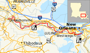
Louisiana Highway 18 (LA 18) is a state highway that serves Ascension, St. James, St. John the Baptist, St. Charles, and Jefferson Parishes. Called the Great River Road, it runs from west to east, parallel to the west bank of the Mississippi River, running from Donaldsonville to Gretna. It spans a total of 79.7 miles (128.3 km).[1] In the more rural parts of LA 18's span, it is commonly referred to as River Road, but it becomes 4th Street once it enters Westwego.
Route description
LA 18 begins as an undivided, two lane road in downtown Donaldsonville as Bayou Road, which runs parallel to the Mississippi River. It intersects with the Sunshine Bridge (LA 70) east of Donaldsonville, the Veterans Memorial Bridge (LA 3213) in Wallace, and Interstate 310 near Luling as it continues downriver. At Bridge City, LA 18 shortly merges with U.S. Highway 90 but continues its eastward span while U.S. 90 crosses the Mississippi River via the Huey P. Long Bridge. When LA 18 enters Westwego, LA 18 becomes 4th Street but still continues alongside the river. In Gretna, LA 18 turns south, away from the river, onto Lafayette Street and ends at the intersection of Lafayette St. and the Westbank Expressway.
History
Between the junction with LA 52 in Luling and Huey P. Long Avenue in downtown Gretna, LA 18 is largely the original routing of U.S. Highway 90 (also LA 2 before the 1955 renumbering) and before that, the Old Spanish Trail highway. (One notable exception is that LA 18 is routed along Louisiana Street rather than the parallel Sala Avenue through Westwego's historic district.)
Major intersections
| Parish | Location | mi[1] | km | Destinations | Notes |
|---|---|---|---|---|---|
| Ascension | Donaldsonville | 0.0 | 0.0 | Western terminus; Western terminus of LA 3089 | |
| | 3.1 | 5.0 | Northwestern terminus of LA 3120 | ||
| St. James | | 8.3 | 13.4 | LA 70 passes overhead via Sunshine Bridge across Mississippi River; indirect access via frontage road | |
| Lagan | 20.4 | 32.8 | Northern terminus of LA 3219 | ||
| North Vacherie | 26.5 | 42.6 | Eastern terminus of LA 20 | ||
| St. John the Baptist | Wallace | 30.9 | 49.7 | Interchange; LA 3213 passes overhead via Gramercy Bridge over Mississippi River | |
| | 33.9 | 54.6 | Northern terminus of LA 639; Unsigned junction | ||
| Edgard | 38.9 | 62.6 | West end of LA 640 concurrency; LA 640 crosses Mississippi River via Reserve-Edgard Ferry to LA 44 and LA 53 | ||
| 39.1 | 62.9 | East end of LA 640 concurrency | |||
| St. Charles | Killona | 46.1 | 74.2 | Northern terminus of LA 3141 | |
| Taft | 48.2 | 77.6 | Northern terminus of LA 3142; Unsigned junction | ||
| Hahnville | 51.8 | 83.4 | Northeastern terminus of LA 3160 | ||
| Luling | 55.1 | 88.7 | Interchange; I-310 passes overhead via Luling Bridge across Mississippi River | ||
| 55.8 | 89.8 | Northern terminus of LA 52 | |||
| 57.3 | 92.2 | Northern terminus of LA 3060 | |||
| Jefferson | | 69.7 | 112.2 | Western terminus of LA 541 | |
| | 70.1 | 112.8 | West end of U.S. 90 concurrency | ||
| Bridge City | 71.0 | 114.3 | East end of U.S. 90 concurrency; At Huey P. Long Bridge across Mississippi River | ||
| Westwego | 72.3 | 116.4 | West end of LA 541 concurrency | ||
| 72.8 | 117.2 | East end of LA 541 concurrency | |||
| 73.3 | 118.0 | Northern terminus of LA 18 Spur | |||
| Marrero | 76.3 | 122.8 | Northern terminus of LA 45; Junction includes incorrect signage | ||
| 76.6 | 123.3 | Southern terminus of LA 560-2 | |||
| Harvey | 77.6 | 124.9 | Northern terminus of LA 3018; Unsigned junction | ||
| 77.6 | 124.9 | Eastern terminus of LA 541 | |||
| 77.7 | 125.0 | Bridge over Harvey Canal | |||
| 77.8 | 125.2 | Northern terminus of LA 3017 | |||
| Gretna | 79.2 | 127.5 | Western terminus of LA 466; Unsigned junction | ||
| 79.7 | 128.3 | Southern terminus; Partially unsigned junction | |||
1.000 mi = 1.609 km; 1.000 km = 0.621 mi
| |||||
Louisiana Highway 18 Spur
| |
|---|---|
| Location: | Westwego |
| Length: | 0.62 mi[1] (1.00 km) |
| Existed: | 1960s–present |
In Westwego, LA 18 turns from Louisiana Street onto 4th Street. LA 18 Spur continues southward for 0.6 miles (0.97 km)[1] on Louisiana Street until it meets the Westbank Expressway (U.S. 90 Business).
The entire highway is in Westwego, Jefferson Parish.
| mi[1] | km | Destinations | Notes | ||
|---|---|---|---|---|---|
| 0.00 | 0.00 | Northern terminus | |||
| 0.62 | 1.00 | Southern terminus | |||
| 1.000 mi = 1.609 km; 1.000 km = 0.621 mi | |||||