Lot 4, Prince Edward Island
| Lot 4, Prince Edward Island | |
|---|---|
| Township | |
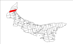 Map of Prince Edward Island highlighting Lot 4 | |
| Coordinates: 46°48′41″N 64°9′54″W / 46.81139°N 64.16500°WCoordinates: 46°48′41″N 64°9′54″W / 46.81139°N 64.16500°W | |
| Country | Canada |
| Province | Prince Edward Island |
| County | Prince County |
| Parish | Egmont Parish |
| Area | |
| • Total | 102.83 km2 (39.70 sq mi) |
| Population (2006) | |
| • Total | 1,175 |
| • Density | 11.4/km2 (30/sq mi) |
| Time zone | AST (UTC-4) |
| • Summer (DST) | ADT (UTC-3) |
| Canadian Postal code | C0B |
| Area code(s) | 902 |
| NTS Map | 021I16 |
| GNBC Code | BAEQQ |
Lot 4 is a township in Prince County, Prince Edward Island, Canada created during the 1764-1766 survey of Samuel Holland. It is part of Egmont Parish.
Communities
Incorporated municipalities:
Civic address communities:
- Alberton
- Bloomfield
- Brockton
- Brooklyn
- Campbellton
- Central Kildare
- Elmsdale
- Glengarry
- Huntley
- Montrose
- O'Brien Road
- Piusville
- Rosebank
- Roseville
- Union
History
Lot 4 was awarded to Augustus Keppel, 1st Viscount Keppel in the 1767 land lottery.[1] The township subsequently went through various owners under feudalism when Prince Edward Island was a British colony prior to Canadian Confederation.
References
- ↑ Clark, Andrew Hill (1959). Three Centuries and the Island. Toronto Press. pp. Appendix B.
| Subdivisions | |
|---|---|
| Cities | |
| Towns | |
| Incorporated communities |
|
| Unincorporated communities | |
| Townships | |
| |
This article is issued from Wikipedia - version of the 5/6/2016. The text is available under the Creative Commons Attribution/Share Alike but additional terms may apply for the media files.