Lost Dutchman State Park
| Lost Dutchman State Park | |
| Arizona State Park | |
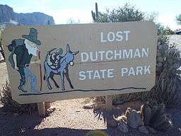 Entrance to the Lost Dutchman State Park | |
| Named for: Lost Dutchman's Gold Mine | |
| Country | United States |
|---|---|
| State | Arizona |
| County | Pinal |
| Location | Apache Junction |
| - elevation | 2,060 ft (628 m) [1] |
| - coordinates | 33°27′22″N 111°28′36″W / 33.45611°N 111.47667°WCoordinates: 33°27′22″N 111°28′36″W / 33.45611°N 111.47667°W |
| Area | 320 acres (129 ha) |
| Founded | 1977 |
| Management | Arizona State Parks |
 Location of Lost Dutchman State Park in Arizona
| |
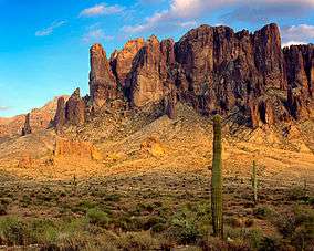
Lost Dutchman State Park is a 320-acre (129 ha) state park located near the Superstition Mountains in central Arizona, USA, and named after the Lost Dutchman's Gold Mine, a famous gold mine legendary among the tales of the Old West. It is easily accessible about 40 miles east of Phoenix via U.S. Highway 60, the Superstition Freeway.
History
The area was first developed as a day use recreation area by the Bureau of Land Management in 1972. The 292 acres (118 ha) abutting the Tonto National Forest was transferred in 1977 via legislative action to the state of Arizona, creating the Lost Dutchman State Park.[2] The park was expanded to 320 acres (130 ha) in 1983.
Features
The park offers camping facilities, day use parking and acts as a trailhead for the trails leading into the Tonto National Forest in which the Superstition Mountains are located. Some of the most popular walks are from the park onto the National Forest Service trails that lead across the western face of the Superstitions (Jacob's Crosscut trail) and up the face of this edge using Siphon Draw trail. Many people confuse these National Forest trails with trails that are maintained by Lost Dutchman State Park.
Siphon Draw and Superstition Ridgeline Trail
Siphon Draw to Flatiron
Siphon Draw is a popular trail, and leads to the iconic "Flatiron" which looks like a ship's bow jutting out of the side of the mountain range. The last mile of hiking up to the Flatiron is a steep boulder scramble. The land is classed as in maintained wilderness area and does not offer trail signs or markers. The last 10 yards of the trail to the Flatiron are a class four scramble called 'The Wall'. Park Rangers recommend gloves. The last mile is not suitable for hiking with dogs.
Superstition Ridgeline Flatiron to Peralta Trailhead
The trail continues along the ridge to Peralta Trailhead about 8 miles away. The section of the trail from Lost Dutchman State Park to the Basin, half way up, is well marked and popular, and required route finding skills are minimal. The last mile up to the Flatiron at the top of the ridge is unmarked wilderness area. From the Flatiron along the top of the ridge to Peralta Trailhead, the trail is much less obvious as it gets much less traffic, marked only by cairns. This area is extremely remote and can be accessed only the trailheads at each end. Hog Canyon or Hieroglyphics Canyon provide possible escape routes in case of emergency, but these trails are more rugged and require more advanced route finding skill than the ridgeline itself. Because of the remote and difficult nature of these canyons, hikers should prepare to finish the entire hike and bring emergency gear with them.
This hike should not be attempted in summer. There is no water along the route, and very little shade, and the amount of water that must be consumed may exceed the carrying capacity of even the strongest hikers. Even in winter or shoulder season, each hiker should carry between one and two gallons of pure water.
The ridgeline has a net elevation gain of about 2800 feet from the lowest point at Siphon Draw Trail head at 2000 feet to the highest point as it skirts Superstition Peak at about 4800 feet. However, the accumulated elevation gain is about 4400 feet, more than Bright Angel Trail in the Grand Canyon. Furthermore, Bright Angel Trail has water available from potable water stations, and from proximity to Bright Angel Creek and the Colorado River, while the Superstition Ridgeline does not have water. [3]
Proposed closure averted
The park was scheduled to close on June 3, 2010.[4] A man from Katy, Texas donated $8,000 so the park could stay open.[5]
References
- ↑ "Lost Dutchman State Park". Geographic Names Information System. United States Geological Survey. 1984-06-27. Retrieved 2011-03-12.
- ↑ History of Lost Dutchman State Park Retrieved 30 March 2015
- ↑ "Superstition Ridgeline". hikearizona.com. Retrieved 2016-07-19.
- ↑ Arizona State Parks. "Lost Dutchman State Park". Retrieved 2010-03-21.
- ↑ Associated Press (March 21, 2010). "Katy man gives $8,000 to keep Ariz. state park open". Houston Chronicle. Houston, Texas. Retrieved 2010-03-21.