Tonto National Monument
| Tonto National Monument | |
|---|---|
|
IUCN category V (protected landscape/seascape) | |
|
Lower Cliff Dwelling | |
 | |
| Location | Gila County, Arizona, USA |
| Nearest city | Globe, Arizona |
| Coordinates | 33°39′25″N 111°5′40″W / 33.65694°N 111.09444°WCoordinates: 33°39′25″N 111°5′40″W / 33.65694°N 111.09444°W |
| Area | 1,120 acres (450 ha)[1] |
| Created | October 21, 1907 |
| Visitors | 53,426 (in 2011)[2] |
| Governing body | National Park Service |
| Website | Tonto National Monument |
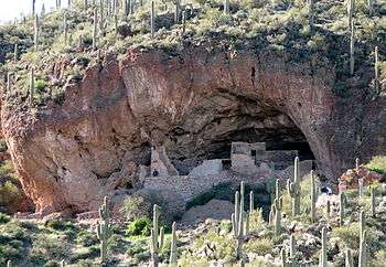

Tonto National Monument is a National Monument in the Superstition Mountains, in Gila County of central Arizona. The area lies on the northeastern edge of the Sonoran Desert ecoregion, an arid habitat with annual rainfall of about 16 inches (400 mm) here.[3] The Salt River runs through this area, providing a rare, year-round source of water.
Cliff dwellings
Well-preserved cliff dwellings were occupied by the Salado culture during the 13th, 14th, and early 15th centuries. The people farmed in the Salt River Valley, and supplemented their diet by hunting and gathering native plants. The Salado were fine craftspeople, producing some of the most flamboyant polychrome pottery and intricately woven textiles to be found in the Southwest. Some of the artifacts excavated nearby are on display in the visitor center museum.
The Tonto National Monument Archeological District was listed on the National Register of Historic Places on October 15, 1966.[4] Tonto National Monument, Lower Ruin and Tonto National Monument, Upper Ruin are archeological sites that were NRHP-listed in 1989.[4][lower-alpha 1]
Natural history
The National Monument is surrounded by the Tonto National Forest, which includes low plains, desert scrubland, and alpine pine forests.
The Upper Sonoran ecosystem is known for its characteristic saguaro cacti. Other common plants include: cholla, prickly pear, hedgehog, and barrel cactus (flowering from April to June); yucca, sotol, and agave; creosote bush and ocotillo; palo verde and mesquite trees; an amazing variety of colorful wild flowers in good years (February to March); and a lush riparian area which supports large Arizona Walnut, Arizona Sycamore, and hackberry trees.
It also serves as a home for native animals such as whitetail and mule deer, mountain lion, bobcat, three rattlesnake species and many more.
Wilderness areas
The area around Tonto National Monument also includes several designated National Wilderness Areas, including Four Peaks, Superstition, and Salome Wilderness Areas.
Photo Gallery
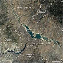 Landsat 7 image of Tonto National Monument (right center), and the surrounding area
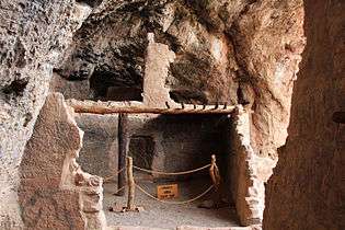 Tonto National Monument, AZ, Room detail
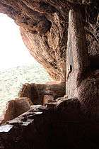 Tonto National Monument, AZ, room detail
 Tonto National Monument, AZ, room detail
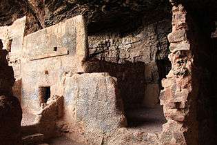 Tonto National Monument, AZ, Room detail
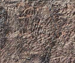 Tonto National Monument, AZ, hand prints on wall
 Tonto National Monument, AZ, looking west
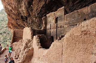 Tonto National Monument, AZ, looking along west face
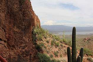 Tonto National Monument, looking east
Notes
- ↑ All three NRHP-listed areas are included within the National Monument, but the National Monument itself is not NRHP-listed
References
- ↑ "Listing of acreage as of December 31, 2011". Land Resource Division, National Park Service. Retrieved 2012-05-14.
- ↑ "NPS Annual Recreation Visits Report". National Park Service. Retrieved 2012-05-14.
- ↑ Roosevelt 1 WNW, Arizona - Climate Summary. Western Regional Climate Center.
- 1 2 National Park Service (2009-03-13). "National Register Information System". National Register of Historic Places. National Park Service.
- "Tonto National Monument, Arizona". NASA Earth Observatory. Retrieved 2006-05-05.
External links
| Wikimedia Commons has media related to Tonto National Monument. |
- Apache Trail website: Ancient Cliff Dwellings Info
- NPS: official Tonto National Monument website
- Tonto National Monument: Saving a National Treasure
- American Southwest, a National Park Service Discover Our Shared Heritage Travel Itinerary
- Tonto National Monument: a traveller's diary