Logatec
| Logatec | |
|---|---|
 | |
 Logatec Location in Slovenia | |
| Coordinates: 45°55′0.13″N 14°13′47.02″E / 45.9167028°N 14.2297278°ECoordinates: 45°55′0.13″N 14°13′47.02″E / 45.9167028°N 14.2297278°E | |
| Country |
|
| Traditional region | Inner Carniola |
| Statistical region | Central Slovenia |
| Municipality | Logatec |
| Area | |
| • Total | 39.50 km2 (15.25 sq mi) |
| Elevation | 476.5 m (1,563.3 ft) |
| Population (2012) | |
| • Total | 9,091 |
| [1] | |
Logatec (pronounced [lɔˈɡaːtəts]; German: Loitsch, Italian: Longatico) is a town in Slovenia. It is the seat of the Municipality of Logatec.[2] It is located roughly in the centre of Inner Carniola, between the capital Ljubljana and Postojna. The town of Logatec has seen rapid industrial development and immigration since the completion of the nearby A1 motorway to the coast.
Name
The name Logatec is of Celtic origin, probably derived from Celtic *longatis 'ferryman, boatman', from the Celtic root *longo- 'boat', thus meaning 'ferrymen's settlement'. The name became Longaticum in Latin, which was borrowed into Slavic as *Lǫgatьcь. Early attestations of the Slavic name include Logach in 1265 (and Logatzc in 1296, Logatsch in 1307, Logacz in 1319, and de Logas in 1354).[3]
History
The earliest mentions of the settlement are from Roman times (Roman way station Mansio Longatico). The vicinity of trade routes between the interior and the coast has always played an important part in the region. First the Roman road from Aquileia to Emona, and later the road to Trieste and the Southern Railway. Before the construction of railway line, the majority of the population made a living as teamsters.[4]
The town of Logatec was formed by combining a number of former villages:
- Blekova Vas (Blekova vas, German: Fleckdorf[5]:14)
- Brod. The name of the settlement was changed from Brod to Brod-Logatec in 1953. It was joined to Logatec in 1972.[6]
- Cerkovska Vas (Slovene: Cerkovska vas)
- Čevica (German: Tscheuze[5]:14), joined to Logatec in 1972.[6]
- Dolenja Vas (Slovene: Dolenja vas)
- Dolenji Logatec (German: Unterloitsch[5]:15), joined to Logatec in 1972.[6]
- Gorenja Vas (Slovene: Gorenja vas). The name of the settlement was changed from Gorenja vas to Gorenja vas pod Režišami in 1953. It was joined to Logatec in 1972.[6]
- Gorenji Logatec (German: Oberloitsch[5]:14), joined to Logatec in 1972.[6]
- Mandrge
- Martinj Hrib, joined to Logatec in 1972.[6]
Because these were originally separate settlements, there are a number of churches in what is now the town of Logatec. The parish church is in the area of Dolenji Logatec and is dedicated to Saint Nicholas. It was first mentioned in written documents dating to 1526. In 1795 to 1803 a new church was built on the site. The church in the Čevica area is dedicated to Saint Joseph and in Gorenji Logatec to the Virgin Mary.[7]
The town's brass band was founded in 1913.[8]
Mass graves
Logatec is the site of three known mass graves from during or after the Second World War. The Šemon Shaft Mass Grave (Slovene: Grobišče Šemonovo brezno) lies on the southern slope of Strmica Hill north of the town. The entrance to the 27 m shaft is marked by two pine trees. The grave contains the remains of civilians from the nearby village of Rovte that were murdered in May or June 1945.[9] The Košovec Shaft Mass Grave (Grobišče Brezno na Košovcu) is a 45 m shaft located in the middle of a woods about 2 km south of Logatec. In addition to human remains, investigators have found German identification tags, gold dentures, a ring, ammunition, and remains of military and civilian footwear in the shaft.[10] The Gradišnica Cave Mass Grave (Grobišče Jama Gradišnica) lies south of Logatec. It contains the remains of two to five unknown victims.[11]
Gallery
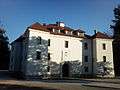 Logatec Castle
References
- ↑ Statistical Office of the Republic of Slovenia
- ↑ Logatec municipal site
- ↑ Snoj, Marko. 2009. Etimološki slovar slovenskih zemljepisnih imen. Ljubljana: Modrijan and Založba ZRC, p. 243.
- ↑ Milan Trobič, Furmani - po cesarskih cestah skozi Postojnska vrata, Logatec: Občina Logatec 2003.
- 1 2 3 4 Intelligenzblatt zur Laibacher Zeitung, no. 141. 24 November 1849.
- 1 2 3 4 5 6 Spremembe naselij 1948–95. 1996. Database. Ljubljana: Geografski inštitut ZRC SAZU, DZS.
- ↑ Logatec parish site
- ↑ "Logatec Brass Orchestra - Culture of Slovenia". Retrieved 2011-11-09.
- ↑ Šemon Shaft Mass Grave on Geopedia (Slovene)
- ↑ Košovec Shaft Mass Grave on Geopedia (Slovene)
- ↑ Gradišnica Cave Mass Grave on Geopedia (Slovene)
External links
| Settlements | Administrative centre: Logatec
|  | ||||||
|---|---|---|---|---|---|---|---|---|
| Landmarks |
| |||||||