Llangattock Lingoed
| Llangattock Lingoed | |
| Welsh: Llangatwg Lingoed | |
 Church of St Cadoc |
|
 Llangattock Lingoed |
|
| OS grid reference | SO362201 |
|---|---|
| Principal area | Monmouthshire |
| Ceremonial county | Gwent |
| Country | Wales |
| Sovereign state | United Kingdom |
| Post town | ABERGAVENNY |
| Postcode district | NP7 |
| Dialling code | 01873 |
| Police | Gwent |
| Fire | South Wales |
| Ambulance | Welsh |
| EU Parliament | Wales |
| UK Parliament | Monmouth |
|
|
Coordinates: 51°52′32″N 2°55′43″W / 51.875428°N 2.928747°W
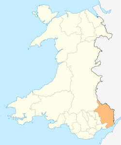
Llangattock Lingoed (Welsh: Llangatwg Lingoed) is a small rural village in Monmouthshire, south east Wales. It is located approximately five miles north of Abergavenny, between Abergavenny and Grosmont, a few miles south of the Wales-England border. Offa's Dyke Path passes through the village. The village is near the Black Mountains and the Brecon Beacons National Park.
Amenities and history
The parish church is St Cadoc's and both the village and the church have a long and interesting history sandwiched as they are in the Welsh Marches between border castles and the historical personalities holding sway at any given time.[1]
The Cistercian Way long distance footpath that circumnavigates all of Wales also passes through the village.
References
External links
- The parish name
- Map sources for Llangattock Lingoed