Llandanwg
| Llandanwg | |
 Llandanwg (left) and Llanfair (on the hill) |
|
 Llandanwg |
|
| OS grid reference | SH570285 |
|---|---|
| Community | Llanfair |
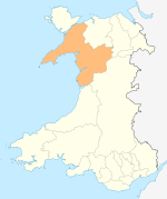
| Principal area | Gwynedd |
| Ceremonial county | Gwynedd |
| Country | Wales |
| Sovereign state | United Kingdom |
| Post town | HARLECH |
| Postcode district | LL46 |
| Dialling code | 01341 |
| Police | North Wales |
| Fire | North Wales |
| Ambulance | Welsh |
| EU Parliament | Wales |
| UK Parliament | Dwyfor Meirionnydd |
| Welsh Assembly | Dwyfor Meirionnydd |
Coordinates: 52°50′06″N 4°07′26″W / 52.835°N 4.124°W
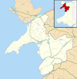
Llandanwg is a village in the Ardudwy area of Gwynedd, Wales. It is situated on the coast, has a railway station and a medieval church in the sand dunes behind the beach which is a Grade II listed building.
The village
The village of Llandanwg is situated to the west of the A496 coastal road between Llanbedr and Harlech, close to the village of Llanfair and about two miles south of Harlech. Originally it was a small collection of farms to the north of the river Artro, close to where it enters the sea.[1] Later developments expanded the size of the village. The village has a railway station, Llandanwg Halt, where trains on the Cambrian Line stop on request. However a new evening train service was introduced in 2015 which angered local residents when it was found that it would not stop at Llandanwg and certain other halts.[2]
There is an easily accessible, shelving beach at the end of the road through the village. It is part of the Snowdonia National Park. Nearby is Mochras or "Shell Island", accessible by a causeway but only at low-tide.[3] The Llandanwg Holiday Home Park provides statics holiday homes on a hillside above the village with extensive views over Tremadog Bay.[4]
The Church of Saint Tanwg
The parish church of Saint Tanwg at Llandanwg is situated just behind the beach in the sand dunes just 20 metres (66 ft) above the high tide mark. The church is medieval, probably dating from the 13th century, however there are three fifth to sixth century inscribed stones and two stones with inscribed crosses inside the building which indicates much earlier activity, and it has probably been a place of worship since the early 5th century. Much of the churchyard is buried in sand. The church is a Grade II Listed building.[5] The churchyard contains the war graves of a Royal Welsh Fusiliers soldier and Royal Garrison Artillery officer of World War I.[6]
Llandanwg Gallery
 Llandanwg church from the churchyard
 Llandanwg church from Y Maes
 Llandanwg viewed from above the main road with Mochras (Shell Island) in the background
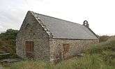
 Llandanwg Halt, a design typical of the Cambrian line. The Great Western opened many such halts between 1923 and 1935 along this line similar to this one.
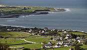 Llandanwg and Shell Island from the north
References
- ↑ "Landranger 124: Dolgellau and surrounding area". 1.25 inch map. Ordnance Survey.
- ↑ Butler, Ben (19 May 2015). "Gwynedd villages left off new train timetable". Daily Post. Retrieved 26 April 2016.
- ↑ "Welcome to Llandanwg". Snowdonia: Mountains and Coast. Gwynedd Council. Retrieved 26 April 2016.
- ↑ "Welcome to Llandanwg". Salop Caravan Sites. Retrieved 26 April 2016.
- ↑ "St Tanwg's Church, Llandanwg". Coflein. Royal Commission on the ancient and historical monuments of Wales. Retrieved 26 April 2016.
- ↑ CWGC cemetery report, details from casualty record.
External links
| Wikimedia Commons has media related to Llandanwg. |
- National Rail - Llandanwg Halt
- Good Beach Guide - Llandanwg
- www.geograph.co.uk : photos of Llandanwg and surrounding area
- Llandanwg Beach, St. Tanwg Church, North Wales, UK on YouTube