Dinas Dinlle
| Dinas Dinlle | |
 Dinas Dinlle |
|
 Dinas Dinlle |
|
| OS grid reference | SH435568 |
|---|---|
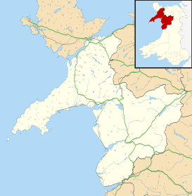
| Community | Llandwrog |
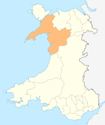
| Principal area | Gwynedd |
| Country | Wales |
| Sovereign state | United Kingdom |
| Post town | CAERNARFON |
| Postcode district | LL54 |
| Dialling code | 01286 |
| Police | North Wales |
| Fire | North Wales |
| Ambulance | Welsh |
| EU Parliament | Wales |
| UK Parliament | Arfon |
| Welsh Assembly | Arfon |
Coordinates: 53°05′10″N 4°20′10″W / 53.086°N 4.336°W
| Dinas Dinlle | |
|---|---|
 Location within Wales | |
| General information | |
| Architectural style | Iron Age hillfort |
| Country | Wales |
| Coordinates | 53°05′10″N 4°20′11″W / 53.086034°N 4.336252°W |
| Technical details | |
| Size | 150 m x 110m |
Dinas Dinlle is a small settlement in Gwynedd, north-west Wales which is also, historically, part of Caernarfonshire.
Description
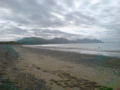
Dinas Dinlle has a large sand and pebble beach with vast areas of sand from mid-tide level. The foreshore consists of natural pebble banks. The popular beach offers views towards the Llŷn Peninsula (Penrhyn Llŷn) and towards Ynys Llanddwyn (Llanddwyn Island) on Anglesey. The area is a designated Site of Special Scientific Interest (SSSI). According to the 2011 Census, 77.9% of the population were Welsh speakers.
The cliff above the beach is known as Boncan Dinas and is occupied by an Iron Age hillfort, Dinas Dinlle. This fort has been eroded by the sea, such that only a double semi-circular rampart remains. Finds of Roman pottery indicate a reoccupation in the 2nd or 3rd centuries.[1] The fort is about 164 yards from north to south by 120 yards with an entrance on the south west. It is possible that a Roman lighthouse originally stood here.[2] It is possible to make out small depressions which are thought to indicate the sites of Iron Age huts and the mound may be the remains of a barrow.[3]
A small airport, Caernarfon Airport, is nearby. During the Second World War this was an RAF base but now it is mainly used for flying lessons and pleasure flights. A caravan park is located nearby.
The erosion by the sea is a substantial problem. A groyne built in 1994 to alleviate the problem was thought to be a mistake that had made the situation worse by 2013. The height of the groyne was to be reduced and the large boulders removed. This was important to preserve the beach and the Wales Coast Path.[4]
Gallery


See also
References
- ↑ "Aerial photograph of Dinas Dinlle Iron Age hillfort". Gathering The Jewels. Retrieved 18 September 2006.
- ↑ Royal Commission of the Ancient and Historical Monuments in Wales Dinas Dinlle (site 95309) accessed March 2013
- ↑ Megalithic Portal Dinas Dinlle, accessed 8 March 2013
- ↑ Dinas Dinlle beach erosion plan unveiled, BBC News, February 2013, accessed 8 March 2013
External links
| Wikimedia Commons has media related to Dinas Dinlle. |
| Wikivoyage has a travel guide for Dinas Dinlle. |