Livingston Wheeler, New Mexico
| Livingston Wheeler, New Mexico | |
|---|---|
| Census-designated place | |
 Livingston Wheeler | |
| Coordinates: 32°23′40″N 104°11′53″W / 32.39444°N 104.19806°WCoordinates: 32°23′40″N 104°11′53″W / 32.39444°N 104.19806°W | |
| Country | United States |
| State | New Mexico |
| County | Eddy |
| Area[1] | |
| • Total | 1.626 sq mi (4.21 km2) |
| • Land | 1.626 sq mi (4.21 km2) |
| • Water | 0 sq mi (0 km2) |
| Elevation | 3,104 ft (946 m) |
| Population (2010)[1] | |
| • Total | 609 |
| • Density | 370/sq mi (140/km2) |
| Time zone | Mountain (MST) (UTC-7) |
| • Summer (DST) | MDT (UTC-6) |
| Area code(s) | 575 |
| GNIS feature ID | 2584141[2] |
Livingston Wheeler is an unincorporated community and census-designated place in Eddy County, New Mexico, United States. Its population was 609 as of the 2010 census.[1] The community is located on the southeastern edge of Carlsbad along New Mexico State Road 216.
Geography
Livingston Wheeler is located at 32°23′40″N 104°11′53″W / 32.394441°N 104.197948°W. According to the U.S. Census Bureau, the community has an area of 1.626 square miles (4.21 km2), all of it land.[1]
References
Municipalities and communities of Eddy County, New Mexico, United States | ||
|---|---|---|
| Cities | 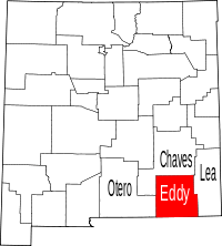 | |
| Villages | ||
| CDPs | ||
| Unincorporated communities | ||
This article is issued from Wikipedia - version of the 2/18/2016. The text is available under the Creative Commons Attribution/Share Alike but additional terms may apply for the media files.