Listed buildings in Rishton
Rishton is a small town in Hyndburn, Lancashire, England. It contains ten listed buildings, which are designated by Historic England and recorded in the National Heritage List for England. Of these, one is listed at Grade II*, the middle grade, and the others are at Grade II. There are no listed buildings inside the town itself, which is surrounded by a rural area, and most of the listed buildings are, or originated as, farmhouses. The Leeds and Liverpool Canal passes through the area, and three bridges crossing it are listed.
Key
| Grade | Criteria[1] |
|---|---|
| II* | Particularly important buildings of more than special interest |
| II | Buildings of national importance and special interest |
Buildings
| Name and location | Photograph | Date | Notes | Grade |
|---|---|---|---|---|
| Parker's Farmhouse 53°45′22″N 2°25′34″W / 53.75624°N 2.42606°W |
— |
c. 1600 (probable) | A sandstone farmhouse, partly rendered, with a stone-slate roof, it is in two storeys and three bays. On the front is a gabled two-storey porch with a Tudor arched doorway and a large lintel, and at the rear is an outshut stair turret. The windows are mullioned, and one window also has a transom. Inside is an inglenook, and timber-framed partitions with wattle and daub infill.[2][3] | II* |
| Whitebirk North Cottage 53°45′31″N 2°26′28″W / 53.75853°N 2.44114°W |
— |
Early 17th century (probable) | Originally a farmhouse, it has been extended and converted into a private dwelling. The house is in rendered stone with stone-slate roofs. It is in three parts, the central part with two storeys, a low single-storey service wing to the right, and a two-storey extension to the left. Some of the windows are mullioned.[4] | II |
| Windy Bank Farmhouse 53°46′29″N 2°26′55″W / 53.77465°N 2.44857°W |
— |
Early 17th century (probable) | The farmhouse is in sandstone with a stone-slate roof. It has two storeys and three bays, with an outshut at the rear. There are two porches, the older porch with two storeys, and the later gabled porch with one. Some of the windows are mullioned and others have been altered.[5] | II |
| Manor House Farmhouse 53°46′34″N 2°24′29″W / 53.77605°N 2.40814°W |
— |
17th century | The sandstone farmhouse has a stone-slate roof, it is in two storeys and three bays. The doorway has a Tudor arch, some of the windows have retained their mullions, and others have been altered.[6] | II |
| Rose Cottage 53°45′21″N 2°25′35″W / 53.75586°N 2.42636°W |
— |
17th century | The former farmhouse is in stone with a slate roof. It has two storeys and an L-shaped plan, consisting of a two-bay range, and a cross-wing. There is a lean-to porch in the angle, and the windows are mullioned. Inside the cross-wing is a timber-framed partition.[7] | II |
| Whitebirk Moss Farmhouse 53°45′28″N 2°26′31″W / 53.75790°N 2.44189°W |
— |
17th century | A sandstone farmhouse with a stone-slate roof in two storeys. The farmhouse has three bays, and an outshut of two bays. On the front is a two-storey gabled porch. The windows are mullioned.[2][8] | II |
| Higher Side Beet Farmhouse 53°45′58″N 2°26′36″W / 53.76616°N 2.44347°W |
— |
1699 | The farmhouse is in sandstone with a slate roof. It has two storeys and three bays, and a 19th-century wing at the rear. There is a modern brick porch with an old inscribed lintel, to the left of which is a stair light. Some windows have retained their mullions, and others have been altered.[9] | II |
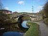
| Canal bridge number 106, (Side Beet Bridge) 53°46′01″N 2°26′48″W / 53.76681°N 2.44666°W |
 |
c. 1810 | The bridge carries Side Beet Lane over the Leeds and Liverpool Canal. It is in sandstone, and consists of a single elliptical arch with a flat deck, rusticated voussoirs, bands, and parapets with ridged coping. The ends are curved and have pilasters.[10] | II |
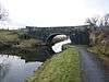
| Canal bridge number 107, (Cut Lane Bridge) 53°46′10″N 2°26′00″W / 53.76946°N 2.43345°W |
_on_the_Leeds-Liverpool_Canal_-_geograph.org.uk_-_35583.jpg) |
c. 1810 | The bridge carries Cut Lane over the Leeds and Liverpool Canal. It is in sandstone, and consists of a single elliptical arch with rusticated voussoirs, bands, parapets rising to a point and pilasters at the ends.[11] | II |
| Canal bridge number 108, (Tottleworth Bridge) 53°46′23″N 2°24′52″W / 53.77306°N 2.41436°W |
 |
c. 1810 | The bridge carries Bridge Street over the Leeds and Liverpool Canal. It is in sandstone, and consists of a single high elliptical arch rusticated voussoirs, bands, parapets with copings, and pilasters at the ends. The bridge also carries a large pipe across its south side.[12] | II |
References
Citations
- ↑ Historic England
- 1 2 Hartwell & Pevsner (2009), p. 575
- ↑ Historic England (1206115)
- ↑ Historic England (1206107)
- ↑ Historic England (1072701)
- ↑ Historic England (1072705)
- ↑ Historic England (1072703)
- ↑ Historic England (1072700)
- ↑ Historic England (1072704)
- ↑ Historic England (1206129)
- ↑ Historic England (1206123)
- ↑ Historic England (1072702)
Sources
- Hartwell, Clare; Pevsner, Nikolaus (2009) [1969], Lancashire: North, The Buildings of England, New Haven and London: Yale University Press, ISBN 978-0-300-12667-9
- Historic England, "Parker's Farmhouse, Rishton (1206115)", National Heritage List for England, retrieved 19 March 2015
- Historic England, "Whitebirk North Cottage, Rishton (1206107)", National Heritage List for England, retrieved 19 March 2015
- Historic England, "Windy Bank Farmhouse, Rishton (1072701)", National Heritage List for England, retrieved 18 March 2015
- Historic England, "Manor House Farmhouse, Rishton (1072705)", National Heritage List for England, retrieved 19 March 2015
- Historic England, "Rose Cottage, Rishton (1072703)", National Heritage List for England, retrieved 19 March 2015
- Historic England, "Whitebirk Moss Farmhouse, Rishton (1072700)", National Heritage List for England, retrieved 18 March 2015
- Historic England, "Higher Side Beet Farmhouse, Rishton (1072704)", National Heritage List for England, retrieved 19 March 2015
- Historic England, "Canal Bridge No.106 (Side Beet Bridge), Rishton (1206129)", National Heritage List for England, retrieved 19 March 2015
- Historic England, "Canal Bridge No.107 (Cut Lane Bridge), Rishton (1206123)", National Heritage List for England, retrieved 19 March 2015
- Historic England, "Canal Bridge No.108 (Tottleworth Bridge), Rishton (1072702)", National Heritage List for England, retrieved 19 March 2015
- Historic England, Listed Buildings, retrieved 18 March 2015
This article is issued from Wikipedia - version of the 10/22/2015. The text is available under the Creative Commons Attribution/Share Alike but additional terms may apply for the media files.