List of shipwrecks in the Indian Ocean
This is a list of shipwrecks in the Indian Ocean.
This list is incomplete; you can help by expanding it.
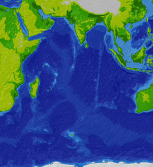
Map of the Indian Ocean
Arabian Sea
| Ship | Sunk date | Notes | Coordinates |
|---|---|---|---|
| SS Aden | 9 June 1897 | A P&O steamship that was wrecked on Socotra island, off the coast of Yemen. | |
| USS Berwyn | 6 September 1920 | A cargo ship that was wrecked near the Khuriya Muriya Islands. | |
| HMS Cadiz | 4 December 1971 | A Battle-class destroyer that was sunk by INS Nirghat south of Karachi. | |
| MOL Comfort | 2013 | A container ship that broke apart in bad weather on 17 June 2013. The stern section took on water and sank on 26 June; the bow was taken under tow, but caught fire and sank on 11 July. | 14°26′N 66°26′E / 14.433°N 66.433°E, 19°56′N 65°25′E / 19.933°N 65.417°E |
| MS Georges Philippar | 19 May 1932 | An ocean liner that caught fire and sank near Al Mukalla, Yemen. | 14°20′N 50°25′E / 14.333°N 50.417°E |
| SS John Barry | 28 August 1944 | A Liberty ship that was torpedoed by U-859 off the coast of Oman. | 15°06′N 55°11′E / 15.10°N 55.18°E |
| INS Khukri | 9 December 1971 | A Blackwood-class frigate that was torpedoed by PNS Hangor off Diu, India. | 20°16′38″N 70°59′37″E / 20.27722°N 70.99361°E |
| SS Santa Paula | 3 June 1943 | A freighter that was torpedoed by I-27 150 miles south of Masirah Island, Oman. | 17°05′04″N 58°05′00″E / 17.08444°N 58.08333°E |
Bay of Bengal
| Ship | Sunk date | Notes | Coordinates |
|---|---|---|---|
| SS Automedon | 11 November 1940 | A passenger and cargo steamer that was sunk by the Atlantis northwest of Sumatra. | |
| HMS Hermes | 9 April 1942 | The world's first purpose-built aircraft carrier, which sunk after receiving 40 direct hits from Vice-Admiral Chuichi Nagumo's 70 Mitsubishi A6M Zero fighter/bombers off the coast of Sri Lanka. | 7°35′N 82°5′E / 7.583°N 82.083°E |
| SS Indus | 10 September 1914 | A steamship that was captured and scuttled by SMS Emden . | 11°00′N 83°45′E / 11.000°N 83.750°E |
| SS Selma City | 7 April 1942 | Attacked by Japanese bombers in the Bay of Bengal, about 25 miles (40 km) offshore from Vizagapatam (now Vishakhapatnam), India. | 17°11′N 83°20′E / 17.183°N 83.333°E |
| HMAS Vampire | 9 April 1942 | A V-class destroyer that was sunk by Japanese aircraft off the coast of Sri Lanka. | 7°35′N 82°5′E / 7.583°N 82.083°E |
Central Indian Ocean
Christmas Island
| Ship | Sunk date | Notes | Coordinates |
|---|---|---|---|
| MV Eidsvold | 20 January 1942 | A motor vessel that was torpedoed by I-159 at Flying Fish Cove. | |
| SIEV-221 | 15 December 2010 | A boat that was carrying asylum seekers from Iraq and Iran when it hit the rocks at Flying Fish Cove. | 10°25′1″S 105°40′24″E / 10.41694°S 105.67333°E |
| MV Tycoon | 8 January 2012 | A cargo ship that was wrecked at Flying Fish Cove. |
Cocos (Keeling) Islands
| Ship | Sunk date | Notes | Coordinates |
|---|---|---|---|
| SS Buresk | 9 November 1914 | A collier that was scuttled while under attack from HMAS Sydney in the Battle of Cocos. | |
| SMS Emden | 9 November 1914 | A light cruiser that was run aground while under attack from HMAS Sydney in the Battle of Cocos. |
Great Australian Bight
| Ship | Sunk date | Notes | Coordinates |
|---|---|---|---|
| Mahomed Shah | April 1853 | A barque that caught fire on 18 April and sank several days later. All on board were rescued. | 40°10′00″S 119°10′00″E / 40.16667°S 119.16667°E |
| SS Selje | 29 March 1929 | A cargo ship that collided with the steamship Kaituna 25 miles southwest of Cape Otway. |
Mozambique Channel
| Ship | Sunk date | Notes | Coordinates |
|---|---|---|---|
| Admiral Gambier | 20 June 1817 | An East Indiaman that was wrecked on a coral reef. | |
| MV Empire City | 6 August 1944 | A cargo ship that was torpedoed by U-198 off Mocímboa da Praia, Mozambique. | 11°33′S 41°25′E / 11.550°S 41.417°E |
| SS Express | 30 June 1942 | A Type C3-E cargo ship that was torpedoed by I-10. | 23°30′S 37°30′E / 23.500°S 37.500°E |
Persian Gulf
| Ship | Sunk date | Notes | Coordinates |
|---|---|---|---|
| Iran Ajr | 26 September 1987 | A landing craft that served as a minelayer during the Iran–Iraq War, and was captured and scuttled by American forces. | |
| U-533 | 16 October 1943 | A Type IXC/40 U-boat that was sunk by British aircraft off the coast of Fujairah. | 25°28′N 56°50′E / 25.467°N 56.833°E |
Red Sea
| Ship | Sunk date | Notes | Coordinates |
|---|---|---|---|
| Aida | 15 September 1957 | An Egyptian supply ship, sunk off the coast of Big Brother Island.[1] | 26°19′N 34°50′E / 26.317°N 34.833°E |
| Al-Baraqua II | 6 April 2006 | Capsized passenger ferry. | |
| MS al-Salam Boccaccio 98 | 3 February 2006 | Capsized passenger ferry. | 27°01′59″N 34°52′59″E / 27.033°N 34.883°E |
| SS Carnatic | 15 September 1849 | Ran aground on a coral reef on 12 September, broke in half and sank three days later. 31 people drowned.[2][3] | 27°34′N 33°55′E / 27.567°N 33.917°E |
| Chrisoula K | 31 August 1981 | Greek freighter that ran aground on a reef.[4] | 27°34′53″N 33°55′55″E / 27.58139°N 33.93194°E |
| SS Dunraven | 25 April 1876 | Hit a reef in the Gulf of Suez, close to the Sinai peninsula.[5] | 27°25′17″N 34°04′23″E / 27.4215°N 34.0730°E |
| Giannis D | 19 April 1983 | Sank with its cargo of timber at Sha'ab Abu Nuhas, north of Hurghada.[6] | |
| Kimon M | 12 December 1978 | Sank on at Sha'ab Abu Nuhas, north of Hurghada, when she ran into the reef of Abu Nuhas.[7][8] | 27°34′48″N 33°56′00″E / 27.58000°N 33.93333°E |
| Numidia | 20 July 1901 | Sank at Big Brother Island.[9] | 26°19′N 34°50′E / 26.317°N 34.833°E |
| El Mina | 1969 | Former Russian navy ship, bombed by the Israelis and sank near Hurghada.[10] | 27°13′55″N 33°51′34″E / 27.23194°N 33.85944°E |
| SS Rosalie Moller | October 1941 | Bombed 2 days after the supply ship Thistlegorm – anchored some 20 miles (32 km) away next to the Sinai peninsula – was sunk. She rests north of Hurghada, north of the reefs of Abu Nuhas, in some 50 meters of water.[11][12] | 27°39′03″N 33°46′17″E / 27.65083°N 33.77139°E |
| Salem Express | 17 December 1991 | Ran into a shallow reef and sank 57 miles (about 91 km) south of Hurghada, after the captain took a shortcut on his trip from Jeddah (Saudi Arabia) to Safaga in Egypt. | 26°38′22.02″N 34°3′39.9″E / 26.6394500°N 34.061083°E |
| SS Thistlegorm | 6 October 1941 | Sunk by German bombers near Sharm el-Sheikh.[13] | 27°48′51″N 33°55′12″E / 27.81417°N 33.92000°E |
| Zingara | 22 August 1984 | Commonly referred to as the Kormoran, sailed from Aqaba with a cargo of Phosphate Rock and hit the Laguna Reef in the Strait of Tiran. |
Strait of Malacca
References
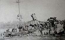
The wreck of SMS Emden
| Wikimedia Commons has media related to Shipwrecks in the Indian Ocean. |
- ↑ TourEgypt report for Numidia.
- ↑ "DiveSiteDirectory for Carnatic". Divesitedirectory.co.uk. Retrieved 27 April 2010.
- ↑ TourEgypt – Carnatic
- ↑ "DiveSiteDirectory for Chrisoula K". Divesitedirectory.co.uk. 31 August 1981. Retrieved 27 April 2010.
- ↑ TourEgypt – SS Dunraven
- ↑ TourEgypt - Giannis D.
- ↑ "DiveSiteDirectory for Kimon M". Divesitedirectory.co.uk. 12 December 1978. Retrieved 27 April 2010.
- ↑ TourEgypt – Kimon M
- ↑ TourEgypt report for Numidia
- ↑ "DiveSiteDirectory for El Mina". Divesitedirectory.co.uk. Retrieved 27 April 2010.
- ↑ "DiveSiteDirectory for Rosalie Moller". Divesitedirectory.co.uk. 19 November 2009. Retrieved 27 April 2010.
- ↑ TourEgypt – Rosalie Moller
- ↑ "DiveSiteDirectory for Thistlegorm". Divesitedirectory.co.uk. Retrieved 27 April 2010.
This article is issued from Wikipedia - version of the 7/27/2016. The text is available under the Creative Commons Attribution/Share Alike but additional terms may apply for the media files.