List of places of worship in Lewes District
.jpg)
There are 69 extant churches and places of worship in the district of Lewes, one of five local government districts in the English county of East Sussex. A further 17 former places of worship are no longer in religious use. The area now covered by the district is mainly rural and characterised by small villages with ancient parish churches. The riverside market town of Lewes, the port of Newhaven and the seaside towns of Seaford, Peacehaven and Telscombe Cliffs are the main urban areas and have higher concentrations of religious buildings.
Most residents of the district identify themselves as Christian, and there are no places of worship serving any other religious groups. Many Christian denominations are represented—the town of Lewes in particular has a long-established history of Protestant Nonconformism—but the majority of churches serve the Church of England community.
English Heritage has awarded listed status to many of Lewes district's places of worship. A building is defined as "listed" when it is placed on a statutory register of buildings of "special architectural or historic interest" in accordance with the Planning (Listed Buildings and Conservation Areas) Act 1990.[2] The Department for Culture, Media and Sport, a Government department, is responsible for this; English Heritage, a non-departmental public body, acts as an agency of the department to administer the process and advise the department on relevant issues.[3] There are three grades of listing status. Grade I, the highest, is defined as being of "exceptional interest"; Grade II* is used for "particularly important buildings of more than special interest"; and Grade II, the lowest, is used for buildings of "special interest".[4]
Location of Lewes and its places of worship

Lewes district covers 113 sq mi (290 km2) of the western part of East Sussex. The English Channel forms its southern boundary for 9 miles (14.5 km); four of the five largest towns in the district—Peacehaven, Telscombe Cliffs, Newhaven and Seaford—are on the coast. Lewes, the administrative centre of the district and the county town of East Sussex, lies inland in the centre of the district. The rest of the district is mostly rural.[5] The city and unitary authority of Brighton and Hove lies to the southwest; the district of Mid Sussex, in the neighbouring county of West Sussex, is to the west; and Lewes's eastern boundary is with Wealden district.[6][7]
The Rape of Lewes, one of the pre-Norman subdivisions of Sussex, had been granted by William the Conqueror to William de Warenne, 1st Earl of Surrey, who had become a major landowner by the time of the Domesday survey in 1086.[8] Outside the town of Lewes itself, most manors and villages had developed by the 12th century, and many of their associated churches date from that time—although the Victorian enthusiasm for church restoration had an effect throughout the district.
The town of Lewes enjoys a strategic position on the River Ouse and surrounded by hills. There is evidence of Anglo-Saxon habitation, and by the 10th century it had become the most important borough in Sussex.[9] The oldest surviving church is St Anne's, the parish church, which is 12th-century. Other churches such as St Andrew's, St Martin's and St Mary-in-the-Market-Place declined and fell out of use by the Middle Ages, and their parishes were combined with others in the town.[10] Nonconformism has been established in the town for more than three centuries: Unitarians, Methodists, Quakers, Baptists, Strict Baptists, Presbyterians and Congregationalists all founded chapels in the 18th or 19th centuries,[10] many of which are still in operation. Newer denominations have also become established: Ian Paisley's Free Presbyterian Church of Ulster, most associated with Northern Ireland, founded one of its seven English congregations in the former Strict Baptist chapel in the Cliffe area of town.[11][12] Ditchling and Wivelsfield were also associated with Nonconformist worship.[13][14]
Religious affiliation
According to the 2001 United Kingdom Census, 92,177 people lived in Lewes district. Of these, 72.02% identified themselves as Christian, 0.44% were Muslim, 0.3% were Buddhist, 0.29% were Jewish, 0.15% were Hindu, 0.03% were Sikh, 0.4% followed another religion, 18.18% claimed no religious affiliation and 8.21% did not state their religion. The proportion of Christians was slightly higher than the 71.74% in England as a whole, while Buddhism and other religions not listed in the Census were also followed by more people than average. The proportion of people with no religious affiliation was much higher than the national figure of 14.59%, but there were fewer followers of Islam, Hinduism, Judaism and Sikhism in the district than in England overall: in 2001, 3.1% of people in England were Muslim, 1.1% were Hindu, 0.7% were Sikh and 0.5% were Jewish.[15]
Administration
All Anglican churches in Lewes district are part of the Diocese of Chichester, whose cathedral is at Chichester in West Sussex.[16] Three archdeaconries—Chichester, Horsham, and Lewes and Hastings—make up the next highest level of administration;[17] the district has at least one church in each. St Laurence's Church in Falmer, which is part of a united parish with Stanmer Church across the border in the city of Brighton and Hove,[18] is part of the Rural Deanery of Brighton,[19] one of five deaneries in the Archdeaconry of Chichester.[17] St Peter and St John the Baptist's Church at Wivelsfield is in the Rural Deanery of Cuckfield,[20] and the churches at Ditchling, Streat and Westmeston are part of the Rural Deanery of Hurst;[21] these are two of the eight deaneries in the Archdeaconry of Horsham.[17] The Archdeaconry of Lewes and Hastings, which also has eight deaneries, is responsible for all other Anglican churches in the district. Except for the churches in Chailey and Newick, which are in the Rural Deanery of Uckfield,[22] all are controlled by the Rural Deanery of Lewes and Seaford.[23]
The Roman Catholic Diocese of Arundel and Brighton, whose cathedral is at Arundel,[24] administers the four Roman Catholic churches in Lewes district. The diocese has 13 deaneries, each with several churches: Brighton and Hove Deanery's 13 churches include the Church of the Immaculate Conception in Peacehaven, Lewes Deanery controls St Pancras' Church at Lewes and five others outside the district, and Eastbourne Deanery is responsible for the Church of the Sacred Heart in Newhaven, St Thomas More Church in Seaford and eight churches in other districts of East Sussex.[25]
The three United Reformed Church congregations, at Lewes,[26] Seaford[27] and Telscombe Cliffs,[28] are in the Southern Synod—one of 13 Synods in Great Britain.[29] The Synod is responsible for about 170 United Reformed churches in Kent, East Sussex, West Sussex and parts of Surrey.[30] In September 2007, the United Reformed and Methodist churches in a large area of central Sussex came together to form a joint administrative group, the Central Sussex United Area.[31] Member churches in Lewes district are Christ Church in Lewes, Chyngton Methodist Church and Cross Way Church in Seaford. St Michael's Anglican church in Newhaven is also involved.[32]
Open places of worship
| Name | Image | Location | Denomination/ Affiliation |
Grade | Notes | Refs |
|---|---|---|---|---|---|---|
| St Mary the Virgin Church |  |
Barcombe 50°54′39″N 0°00′59″E / 50.9108°N 0.0165°E |
Anglican | II* | The church serves a large rural parish whose original settlement declined in the 14th century. Part of the nave is 12th-century; the tower and widened chancel were built a century later. Restoration work in 1879–1880 included replacement of all the ancient lancet windows. Charles Eamer Kempe provided some stained glass. | [33][34] [35][36] [37] |
| Jubilee Christian Centre |  |
Barcombe 50°54′58″N 0°00′51″E / 50.9162°N 0.0141°E |
Baptist | – | Barcombe's first chapel, associated with the Strict Baptist and Calvinist movements, was established in 1810 just off the road to Hamsey. It was a brick structure in the Vernacular style. A modern brick building, registered in 1980, now stands on the site. The FIEC-aligned church changed its name from Barcombe Baptist Church in 2006. | [33][38] [39][40] [41] |
| St Andrew's Church | .jpg) |
Beddingham 50°51′09″N 0°03′05″E / 50.8526°N 0.0515°E |
Anglican | I | The isolated riverside settlement was founded in the 9th century but has declined to a negligible size. The church has Norman origins and was added to over a long period: most of the structural work is 14th- and 16th-century. The flint building has a chancel, nave and tower. | [42][43] [44] |
| St Andrew's Church | |
Bishopstone 50°47′23″N 0°05′16″E / 50.7897°N 0.0877°E |
Anglican | I | Norman settlers rebuilt this village's early-8th-century Anglo-Saxon church, but parts remain in the nave, porch and tower. The 12th-century reconstruction produced an Early English-style flint and stone church. | [45][46] |
| St Peter's Church | .jpg) |
Chailey 50°57′24″N 0°01′09″W / 50.9567°N 0.0192°W |
Anglican | II* | This sandstone and ashlar church retains its 13th-century chancel and tower with its shingled spire. The nave was enlarged (and aisles added) in 1878–1879 by John Oldrid Scott. | [47][48] [49] |
| St Thomas à Becket Church | .jpg) |
Cliffe, Lewes 50°52′28″N 0°01′08″E / 50.8745°N 0.0188°E |
Anglican | II* | Also known as St Thomas-at-Cliffe Church, this sturdy flint structure has work from several periods from the 12th century to the late 19th century, when it was restored twice in quick succession. A square tower rises in three stages at the west end. | [50][51] |
| Lewes Free Presbyterian Church | .jpg) |
Cliffe, Lewes 50°52′32″N 0°01′07″E / 50.8755°N 0.0187°E |
Free Presbyterian Church of Ulster | I | This large chapel was built for a Strict Baptist congregation in 1805 and extended in 1826. The timber-framed building is faced with bricks and slate tiles, there is a Tuscan porch, and the roof is barrel-vaulted. It is one of seven churches in England used by followers of Ian Paisley's Protestant denomination. | [11][12] [52][53] [54] |
| St Leonard's Church | .JPG) |
Denton 50°48′16″N 0°03′46″E / 50.8045°N 0.0628°E |
Anglican | II* | The church has some structural work from the Norman era, and the font is of the same age. The external appearance was altered in the 19th century, but there are some ancient windows. The nave and chancel run into each other with no dividing arch. | [55][56] [57] |
| St Margaret's Church | .jpg) |
Ditchling 50°55′17″N 0°06′57″W / 50.9213°N 0.1157°W |
Anglican | I | The appearance of this church, which stands on raised ground at the village crossroads, is 13th-century, and most of the work was done then. The nave is two centuries older, though, and there are later additions. The cruciform building is of flint and sandstone. The central tower has a squat spire. | [13][58] [59][60] |
| Emmanuel Chapel |  |
Ditchling 50°55′12″N 0°06′54″W / 50.9199°N 0.1149°W |
Evangelical | – | Ditchling's tradition of Nonconformism continues in the 21st century: a former mission hall on this site, opened in the early 20th century and which may have replaced another hall elsewhere, was itself replaced by this building which was registered for marriages in August 1972. It is one of three extant non-Anglican places of worship in the village. | [13][60] [61][62] [63] |
| Friends Meeting House |  |
Ditchling 50°55′21″N 0°06′51″W / 50.9225°N 0.1142°W |
Quaker | – | This small meeting house in the centre of Ditchling serves the village and nearby settlements such as Hassocks and Burgess Hill. | [61][64] [65] |
| Ditchling Unitarian Chapel (The Old Meeting House) | %2C_Ditchling.jpg) |
Ditchling 50°55′18″N 0°06′47″W / 50.9216°N 0.1131°W |
Unitarian | II | Built in 1740 for General Baptists on a twitten off East End Lane, this Vernacular-style chapel is attached to a partly tile-hung house of 1672. The red-brick chapel, with tall windows, was renovated between 1877 and 1887; additions included a gabled porch. | [13][60] [66][67] [68][69] [70] |
| St Peter's Church | .JPG) |
East Blatchington 50°46′44″N 0°06′13″E / 50.7790°N 0.1036°E |
Anglican | II* | Parts of this long, thick-walled church date from the 13th century—in particular the tower, a piscina and a priest's door, with its rounded arch—but Norman origins have been claimed. The chancel has lancet windows. | [71][72] |
| Seaford Baptist Church |  |
East Blatchington 50°46′37″N 0°05′44″E / 50.7769°N 0.0955°E |
Baptist | – | The present building, a low circular structure, was built in the 1970s to replace an Early English-style red-brick church in Seaford town centre, which existed from 1901 until 1973. | [73][74] |
| East Chiltington Church |  |
East Chiltington 50°55′10″N 0°03′09″W / 50.9194°N 0.0525°W |
Anglican | II* | Although this sandstone church now has its own parish, it was a chapel of ease to Westmeston for centuries. The nave is the oldest part: it was built in the early 12th century, and buttresses were added later in the century. The tower is slightly later, and the chancel is 14th-century. | [75][76] [77] |
| St Laurence's Church |  |
Falmer 50°51′45″N 0°04′34″W / 50.8624°N 0.0760°W |
Anglican | II* | A restoration of 1840 was responsible for the unusual Neo-Norman appearance of this church, which was rebuilt between 1815 and 1817 from the demolished ruins of a medieval predecessor. | [78][79] [80] |
| St Mary the Virgin Church | .jpg) |
Glynde 50°51′53″N 0°04′06″E / 50.8646°N 0.0683°E |
Anglican | II* | Sir Thomas Robinson, an advocate of Palladian architecture, rebuilt Glynde's parish church in that style between 1763 and 1765. The boxlike, pedimented cobbled flint and ashlar building has a large cupola containing a bell. Pevsner disliked its stained glass, and the church has been criticised as "being in bad taste". | [81][82] [83][84] |
| St Peter's Church | .jpg) |
Hamsey 50°53′28″N 0°00′34″E / 50.8912°N 0.0095°E |
Anglican | I | This 12th-century church is situated on a slope by a loop in the River Ouse—a very remote spot. The east part of the nave and the west end of the chancel are original; their other parts are 14th-century, as is the tower. A porch was added a century later on the south wall. | [85][86] [87] |
| St Nicholas' Church | .jpg) |
Iford 50°50′54″N 0°00′03″W / 50.8484°N 0.0007°W |
Anglican | I | Victorian restoration has not disguised the 12th-century origins of this small village's church, which stands on the site of a Norman predecessor recorded in the Domesday survey of 1086. The flint structure is long and narrow; the oldest part is the nave, which is separated from the chancel by a substantial, short tower topped by a shingled spire. The windows (mostly lancets) and a piscina are also original. A former north aisle has now vanished. | [88][89] [90] |
| St Pancras' Church |  |
Kingston near Lewes 50°51′23″N 0°01′28″W / 50.8563°N 0.0245°W |
Anglican | II* | The tall and wide chancel and nave are balanced by a curiously slim tower with a tiled pyramidal roof. The church was built in the early 14th century in the Decorated Gothic style. Much of the original stone and flintwork was restored in 1874. | [91][92] [93][94] |
| St Anne's Church | .jpg) |
Lewes 50°52′21″N 0°00′06″E / 50.8724°N 0.0016°E |
Anglican | I | Originally called St Mary Westout in reference to the ancient suburb of Westout, the Early English-style flint exterior reflects a restoration of 1889, but Norman details predominate inside. The long nave has a porch in which a 12th-century door has been inserted. St Anne's is the parish church of Lewes. | [10][95] [96] |
| St Michael's Church | .jpg) |
Lewes 50°52′20″N 0°00′26″E / 50.8723°N 0.0071°E |
Anglican | I | This town-centre church is one of three in the Ouse Valley with a circular west tower, although its 13th-century date is later than the others. It has an octagonal spire and is pebbledashed; the rest of the building is of flint. An aisled nave and chancel run parallel with the High Street. | [10][97] [98] |
| St John sub Castro Church | .jpg) |
Lewes 50°52′34″N 0°00′34″E / 50.8760°N 0.0094°E |
Anglican | II | The dedication means St John under the Castle. An Anglo-Saxon church stood nearby; its chancel arch and a doorway were incorporated into George Cheeseman's new knapped flint Early English-style structure of 1839. The side windows are tall lancets with tracery. | [10][53] [99][100] |
| Eastgate Baptist Church |  |
Lewes 50°52′30″N 0°00′48″E / 50.8751°N 0.0134°E |
Baptist | – | The first Baptist place of worship in the area was a chapel of 1741 in Southover. A flint, yellow brick and stone Romanesque Revival chapel opened in 1843 on Eastgate Street, replacing an 1819 building on the same site. It has a tower and spire at one corner, and was extended in the 20th century. | [10][53] [101][102] [103] |
| Kingdom Hall |  |
Lewes 50°52′19″N 0°00′40″E / 50.8720°N 0.0111°E |
Jehovah's Witnesses | – | This is used by the Lewes Congregation of Jehovah's Witnesses. Regular services are held in Sign language. Part of the building was originally a National school built in 1840. | [104][105] [106][107] [108] |
| Friends Meeting House | .jpg) |
Lewes 50°52′21″N 0°00′50″E / 50.8726°N 0.0139°E |
Quaker | II | The town's first meeting house was built in 1675 and altered in 1752; the present brick and mathematical tile structure replaced it in 1784, and an adjoining cottage was built in 1801. There is a brick-faced wooden porch with Doric pilasters topped with a pediment. | [10][101] [109][110] [111][112] |
| St Pancras' Church |  |
Lewes 50°52′21″N 0°00′09″E / 50.8724°N 0.0025°E |
Roman Catholic | – | A stone church built in 1870 and dedicated to the Sacred Heart was replaced in 1938–39 by a larger red-brick and flint building by Edward Walters. It is a simple Gothic-style structure with no tower. | [10][53] [98][113] |
| Westgate Chapel | .jpg) |
Lewes 50°52′18″N 0°00′24″E / 50.8718°N 0.0067°E |
Unitarian | II* | Parts of a late-16th-century inn were used in this chapel, built in about 1700. The timber-framed building has a plain exterior with some knapped flintwork. The entrance is in a brick porch. Extensions have included a 19th-century library. The early congregations were Presbyterian, but Unitarian views were practised by the time members of the former Southover General Baptist Chapel joined in the early 19th century. | [10][53] [101][114] [103][115] |
| Christ Church |  |
Lewes 50°52′34″N 0°00′09″W / 50.8760°N 0.0025°W |
United Reformed Church/Methodist | – | This modern building houses United Reformed Church and Methodist congregations, and is now the only church in the town serving those denominations. | [116][117] [118] |
| St Mary's Church |  |
Nevill Estate, Lewes 50°52′49″N 0°00′30″W / 50.8802°N 0.0082°W |
Anglican | – | This church on the edge of Lewes, opened in 1938, is a chapel of ease within St Anne's parish. It is used as a church hall and for community activities, and occasional services are held. | [119][120] [121][122] |
| St Michael and All Angels Church | .jpg) |
Newhaven 50°47′30″N 0°02′43″E / 50.7918°N 0.0454°E |
Anglican/ Methodist |
II* | Newhaven's parish church stands on high ground overlooking the town. Its east tower and attached apse (a rare combination) are Norman; William Habershon restored the rest of the church in 1854. The nave has wide aisles and was built in 1791 to replace its Norman predecessor. | [123][124] [125] |
| Newhaven Baptist Church |  |
Newhaven 50°47′37″N 0°02′47″E / 50.7935°N 0.0463°E |
Baptist | – | A chapel built in 1835 was replaced in 1901 by the town's present Baptist church. The red-brick structure stands above the Brighton Road. | [123][126] [127] |
| Elim Pentecostal Community Church |  |
Newhaven 50°47′34″N 0°02′51″E / 50.7929°N 0.0476°E |
Pentecostal | – | A Pentecostal congregation worships at this red-brick building on Meeching Rise in the town centre. It was registered for marriages in April 1966. | [128][129] [130] |
| Church of the Sacred Heart | .JPG) |
Newhaven 50°47′24″N 0°03′05″E / 50.7900°N 0.0514°E |
Roman Catholic | – | Newhaven's Roman Catholic church was built in 1898, reputedly by W. H. Romaine-Walker. The flint and brick structure is in the Neo-Norman style with round-headed windows, and has been extended and altered in the 20th century. | [123][126] [131][132] |
| St Mary's Church |  |
Newick 50°58′09″N 0°01′24″E / 50.9693°N 0.0232°E |
Anglican | II* | Fragments of the original nave, built in about 1100, remain; it was added to in the 14th century when the church was extended and the chancel was added. The latter was taken down and moved during John Oldrid Scott's rebuilding of 1886–1887. The Perpendicular Gothic tower is 15th-century. | [133][134] [135][136] |
| Newick Evangelical Free Church |  |
Newick 50°58′20″N 0°00′26″E / 50.9723°N 0.0071°E |
Evangelical | – | This small building, dating from 1892, was originally a mission hall. It is now used by an Evangelical community as their place of worship and meeting place. | [133][137] [138][139] |
| St Peter's Church | .jpg) |
Offham 50°53′31″N 0°00′36″W / 50.8920°N 0.0099°W |
Anglican | II | Ewan Christian designed this church in the Decorated Gothic style in 1859. The flint and sandstone structure has an apsidal chancel with a tower and spire. Jean-Baptiste Capronnier provided stained glass windows in 1862 and 1876. | [85][140] [141][142] |
| Church of the Ascension |  |
Peacehaven 50°47′35″N 0°00′12″E / 50.7931°N 0.0032°E |
Anglican | – | L. Keir Hett's red-brick church, with a squat tower above its entrance, a side chapel and a gallery, replaced the community's first church—a prefabricated building of 1922. | [143][144] [145][146] |
| Peacehaven Evangelical Free Church |  |
Peacehaven 50°47′25″N 0°00′29″E / 50.7902°N 0.0081°E |
Evangelical | – | This modern brick building, serving an Evangelical congregation, is on the main South Coast Road. | [145][147] |
| Kingdom Hall |  |
Peacehaven 50°47′20″N 0°00′39″E / 50.7889°N 0.0108°E |
Jehovah's Witnesses | – | This modern Kingdom Hall is used by the Newhaven Congregation of Jehovah's Witnesses, and is also situated on the South Coast Road. | [145][148] [108] |
| Church of the Immaculate Conception |  |
Peacehaven 50°47′34″N 0°00′02″W / 50.7929°N 0.0006°W |
Roman Catholic | – | The town's first Roman Catholic church was built in 1925. Intended as a temporary structure, it survives as a church hall, but was deregistered in November 1963 and replaced by a permanent brick church. | [143][145] [146][149] [150] |
| St John's Church | .jpg) |
Piddinghoe 50°48′34″N 0°02′08″E / 50.8095°N 0.0355°E |
Anglican | I | The round tower and the nave of this riverside church are early-12th-century. A north aisle was added a few years later; its roof descends to a very low level outside. The south aisle and an aisled chancel were built by the 13th century; all were restored in 1882. | [143][151] [152] |
| St Michael and All Angels Church |  |
Plumpton 50°54′18″N 0°04′18″W / 50.9051°N 0.0717°W |
Anglican | I | This flint, stone and local marble church, surrounded by Plumpton Agricultural College buildings, is isolated from the village. The nave is mostly 12th-century; the buttressed west tower and its spire is a century newer, as is the chancel; a porch and vestry are later additions. | [153][154] [155] |
| All Saints Church |  |
Plumpton Green 50°56′06″N 0°03′37″W / 50.9350°N 0.0602°W |
Anglican | – | Nikolaus Pevsner thought that Samuel Denman's 1893 church was "plain funny", mainly due to the composition of its octagonal tower. It was originally a chapel of ease to St Michael and All Angels Church, 2 miles (3.2 km) to the south. The ancient font is believed to have come from the old St John sub Castro Church in Lewes. | [153][156] [157] |
| St Mary the Virgin Church | .jpg) |
Ringmer 50°53′38″N 0°03′16″E / 50.8940°N 0.0544°E |
Anglican | I | Norman-era fragments remain in this large church, rebuilt in the 15th century and further altered in 1884 by Ewan Christian. John Christie, founder of the nearby Glyndebourne Opera House, donated the organ. | [158][159] |
| St Peter's Church |  |
Rodmell 50°50′19″N 0°01′04″E / 50.8385°N 0.0177°E |
Anglican | I | Some windows have been replaced, and the chancel arch was restored during the Victorian era, but otherwise the church has changed little since the late 12th century, when the tower and an adjacent room were added to the slightly older chancel and nave. | [160][161] [162] |
| St Leonard's Church | .jpg) |
Seaford 50°46′19″N 0°06′05″E / 50.7719°N 0.1013°E |
Anglican | I | The size of this church reflects Seaford's medieval importance as a port: the River Ouse's estuary was here until it silted up and moved to Newhaven. The nave and some clerestory windows remain from the Norman era, and a sculpture of Saint Michael battling a dragon has been attributed to 1130. The tower is 15th-century. | [163][164] |
| Kingdom Hall |  |
Seaford 50°46′17″N 0°06′01″E / 50.7713°N 0.1003°E |
Jehovah's Witnesses | – | This Kingdom Hall serves the Seaford Congregation of Jehovah's Witnesses. It stands on West Street on the town centre, and was registered for marriages in July 1987. | [165][166] [167][168] |
| Cross Way Church | %2C_Seaford.jpg) |
Seaford 50°46′13″N 0°06′06″E / 50.7702°N 0.1017°E |
Methodist | – | This church is mostly red-brick but also has stone dressings. It was built in the Early English style in 1894 in the town centre. The congregation has formed a partnership with the town's United Reformed Church, and the name "Cross Way" has been adopted. | [169][170] [171] |
| St Thomas More Church |  |
Seaford 50°46′26″N 0°06′26″E / 50.7739°N 0.1073°E |
Roman Catholic | – | In 1935, James O'Hanlon Hughes and Geoffrey Welch built a simple rectangular church with a rendered exterior with some flintwork. In 1969, an extension was built using yellow artificial stone, and the interior was opened up. | [73][172] [173] |
| Seaford Independent Spiritualist Church |  |
Seaford 50°46′25″N 0°06′12″E / 50.7735°N 0.1032°E |
Spiritualist | – | This church was established in 1991. The congregation met in a hall at first, but they later acquired a building (now known as Seafordspirit) in the town centre. Services are held on Thursdays. | [174][175] |
| Cross Way Clinton Centre | %2C_Seaford.jpg) |
Seaford 50°46′24″N 0°06′07″E / 50.7732°N 0.1019°E |
United Reformed Church | – | The "Cross Way" name has been used since the link with the town's Methodist church was forged. Most worship takes place there, but some services are still held in W.F. Poulton's Early English-style flint and ashlar chapel of 1877. Its slender buttressed corner turret is distinctive. The roof has king posts and queen posts. | [164][169] [170][176] [177][178] |
| Chailey Free Church |  |
South Chailey 50°56′14″N 0°01′09″W / 50.9372°N 0.0192°W |
Evangelical | – | This independent Evangelical congregation worships in a modern building on the site of a former mission hall used by Nonconformist groups. This was registered for marriages in 1906 and deregistered in 1992, whereupon the new building was registered in its place. | [47][179] [180][181] [182] |
| St Michael and All Angels Church | .jpg) |
South Malling, Lewes 50°52′52″N 0°00′24″E / 50.8812°N 0.0068°E |
Anglican | II* | A young John Evelyn laid the foundation stone of the rebuilt church in 1626, but the building has 13th-century origins, and the tower arch and its responds survive from the 14th century. A restoration was carried out in 1874. | [183][184] |
| King's Church |  |
South Malling, Lewes 50°52′40″N 0°00′56″E / 50.8778°N 0.0156°E |
Evangelical | – | This Charismatic Evangelical community, founded in 1985 and aligned with Newfrontiers and the Evangelical Alliance, worships in an industrial unit. In 2009, planning permission was granted for a nearby industrial building to be converted into a new church. | [185][186] |
| St Peter's Church |  |
Southease 50°49′46″N 0°01′09″E / 50.8295°N 0.0192°E |
Anglican | I | Like St Michael's Church in Lewes and St John's Church in Piddinghoe, this ancient building has a round tower. The present nave and chancel are housed in the 11th-century nave, whose accompanying chancel was demolished in the 14th century. Wall murals from about 1280 have been uncovered, and the bell is of the same age, making it one of the oldest in Sussex. | [187][188] [189] |
| St John the Baptist's Church | .jpg) |
Southover, Lewes 50°52′09″N 0°00′22″E / 50.8691°N 0.0062°E |
Anglican | I | Although greatly altered, the building was originally the late-11th-century hospitium of the adjacent Lewes Priory, England's first Cluniac House. Its conversion to a church came in the 13th century. The tower collapsed in 1698 and took 40 years to rebuild. Additions were made in the Neo-Norman style in the 19th century. | [53][190] [191][192] |
| Streat Church |  |
Streat 50°55′13″N 0°04′46″W / 50.9202°N 0.0795°W |
Anglican | II* | This modest church, with a nave dating from about 1200, a slightly older chancel and a small belfry with a spire, was heavily restored in 1854; an aisle was added to the nave in that year. In 1882 a porch and vestry were built on the north side. | [193][194] [195] |
| St Luke's Church |  |
Sutton, Seaford 50°46′36″N 0°07′40″E / 50.7766°N 0.1278°E |
Anglican | – | Part of the combined parish of Sutton with Seaford, this multi-purpose modern brick and flint building, built for £15,791, serves the Chyngton and Sutton areas of the town. It has a rounded tower at one corner. The site was acquired in 1954, the first stone was laid on 8 November 1958 and the church was opened in June 1959. | [57][196] |
| Seaford Community Church |  |
Sutton, Seaford 50°46′49″N 0°06′53″E / 50.7802°N 0.1147°E |
Evangelical | – | This independent Evangelical community worships in a modern building on Vale Road in the east of Seaford. Under the name Seaford Evangelical Free Church, it was registered for marriages in May 1969. | [197][198] [199] |
| Chyngton Methodist Church | Sutton, Seaford 50°46′48″N 0°07′38″E / 50.7799°N 0.1273°E |
Methodist | – | This church, housed in a multi-purpose building used by many groups from the local community, serves Methodists in the Chyngton and Sutton areas of Seaford. | [200][201] | |
| St Mary's Church |  |
Tarring Neville 50°48′57″N 0°02′55″E / 50.8157°N 0.0487°E |
Anglican | I | There is a nave and south aisle under an undivided roof, chancel and west tower with a tiled pyramidal roof at this 13th-century church near Newhaven. Instead of the usual free-standing font, there is one attached to the aisle wall; this was added in the 14th century. | [202][203] |
| St Lawrence's Church |  |
Telscombe 50°48′46″N 0°00′23″W / 50.8128°N 0.0064°W |
Anglican | I | The 12th-century church is one of the only buildings in the hamlet, which is reached down a long road from Southease. The nave has one aisle, and there is a chancel with a Lady chapel, a small vestry, porch and tower. The chancel arch looks Norman but is 19th-century; the Lady chapel and north aisle were also rebuilt then. | [204][205] [206] |
| Telscombe Cliffs United Reformed Church |  |
Telscombe Cliffs 50°47′46″N 0°01′05″W / 50.7961°N 0.0181°W |
United Reformed Church | – | This United Reformed church, one of four in the district, serves the coastal urban area of Peacehaven and Telscombe Cliffs. | [145][207] |
| St Peter's Church |  |
West Firle 50°50′42″N 0°05′18″E / 50.8450°N 0.0884°E |
Anglican | I | One reset doorway, dating from about 1200, is the oldest part of this church. The rest of the structure was built in the late 13th and 14th centuries. The nave has north and south aisles, and there is a vestry and porch. A crenellated tower with substantial buttresses stands at the west end. Adjoining the 13th-century chancel is a private chapel (the Gage Chapel) for members of the Gage baronetcy. | [208][209] |
| St Martin's Church |  |
Westmeston 50°54′24″N 0°05′50″W / 50.9067°N 0.0972°W |
Anglican | II* | This small church beneath the South Downs serves a long, narrow parish, and administered East Chiltington's church until 1934. The structure is of flint and sandstone, but 19th-century restoration has obscured its original appearance. The nave is mostly 12th-century, but its south aisle was added later. | [210][211] [212] |
| St Peter and St John the Baptist's Church | 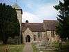 |
Wivelsfield 50°58′15″N 0°05′43″W / 50.9709°N 0.0952°W |
Anglican | II* | Some 11th-century masonry and a doorway remain from the original building. Although it is mostly 13th-century, the present church has parts from a range of architectural eras—the legacy of a 14th-century lengthening, a restoration of 1869, and other work. | [14][213] |
| Bethel Strict Baptist Chapel |  |
Wivelsfield 50°57′46″N 0°05′43″W / 50.9627°N 0.0952°W |
Baptist | II | The secession of some members from Ditchling's Baptist community in 1763 led to the founding of a new Strict Baptist chapel in nearby Wivelsfield in 1780. The building has one weatherboarded bay but is mostly of brick, and has been enlarged several times from its original rectangular layout. | [14][214] [215][216] [217] |
| Ote Hall Congregational Chapel |  |
Wivelsfield 50°58′04″N 0°05′27″W / 50.9678°N 0.0907°W |
Countess of Huntingdon's Connexion | II | Selina Hastings, Countess of Huntingdon, who lived in the village, founded a chapel for her Calvinist sect in 1778. The glazed brick building was completed in 1780. The windows and original (now blocked) entrance door are round-arched, and the tiled roof is hipped. | [14][214] [218][219] [220] |
| Church of Jesus Christ of Latter-day Saints |  |
Wivelsfield Green 50°57′49″N 0°04′24″W / 50.9635°N 0.0733°W |
Latter-day Saint | – | In 1999, the Church of Jesus Christ of Latter-day Saints gained planning permission to build a church on a derelict site in the centre of Wivelsfield Green village. It is one of several churches in the Crawley Stake. | [221][222] [223] |
Closed or disused places of worship
| Name | Image | Location | Denomination/ Affiliation |
Grade | Notes | Refs |
|---|---|---|---|---|---|---|
| St Francis of Assisi Church | 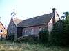 |
Barcombe Cross 50°55′29″N 0°01′11″E / 50.9248°N 0.0196°E |
Anglican | – | The settlement of Barcombe Cross developed north of the old village. Squire of Barcombe Sir William Grantham provided built a timber and brick structure to serve it in the late 1890s. It went out of use in about 2003, and is now used as a community hall and meeting place. | [33][37] [224][225] |
| Protestant Dissenters Mission House |  |
Barcombe Cross 50°55′24″N 0°00′40″E / 50.9234°N 0.0110°E |
Non-denominational | – | This non-denominational mission chapel was established in the first half of the 19th century on the road from Barcombe Cross to Hamsey. It is no longer in religious use. | [33][224] [226] |
| Beulah Strict Baptist Chapel |  |
Ditchling 50°55′20″N 0°06′51″W / 50.9222°N 0.1142°W |
Baptist | – | George Grenyer built a chapel for the Strict Baptist community on East End Lane in 1867. After its closure in the late 1930s it became a private house. | [13][60] [67] |
| St John the Evangelist's Church |  |
East Blatchington 50°46′36″N 0°05′51″E / 50.7767°N 0.0975°E |
Anglican | – | This church was built in the mid-1920s as a second church within the parish of East Blatchington, but closed in 1980. It is now used as a nursery school. The building has a roughcast exterior and tiled roof. | [73] |
| Laughton Methodist Chapel | Laughton 50°54′26″N 0°07′44″E / 50.9073°N 0.1289°E |
Methodist | – | This former chapel and the accompanying Sunday school and minister's house have been converted into a house. It was built around 1879 on the road from Laughton to Shortgate. It was formally registered for marriages between 1934 and 1981. | [227][228] | |
| All Saints Church | .jpg) |
Lewes 50°52′21″N 0°00′48″E / 50.8724°N 0.0134°E |
Anglican | II* | This building—an accumulation of parts from several eras—has been used as an arts and community centre since its redundancy in 1975. The 16th-century flint tower was retained when Amon Wilds built a new nave in 1806; an Early English-style chancel followed in 1883. | [10][53] [229][230] |
| Providence Baptist Chapel |  |
Lewes 50°52′34″N 0°00′40″E / 50.8760°N 0.0112°E |
Baptist | – | This chapel is now a theatre auditorium. It closed in 1932 after about 70 years of religious use. The building, of blue and red brick, stands on Lancaster Street. | [53] |
| Providence Strict Baptist Chapel |  |
Lewes 50°52′31″N 0°00′44″E / 50.8752°N 0.0121°E |
Baptist | – | Opened with the name Gospel Temperance Mission Hall in 1906, this Vernacular-style flint and brick building served as a Baptist chapel from 1924 until about 1980, after which it was converted for residential use. | [53] |
| Wesleyan Methodist Chapel |  |
Lewes 50°52′22″N 0°00′40″E / 50.8727°N 0.0110°E |
Methodist | – | An 18th-century Countess of Huntingdon's Connexion chapel stood on this site; it was taken over by Methodists in 1807 and demolished in 1867 when the present building was built. The Early English-style red-brick and stone building was closed in 1973 and became an antiques centre. | [10][53] |
| Hamilton Memorial Presbyterian Church |  |
Lewes 50°52′27″N 0°00′42″E / 50.8741°N 0.0117°E |
Presbyterian Church of England | – | This large chapel, closed in the 1940s, has also become an antiques showroom and market. It is in the Renaissance style and is mostly of brick. | [10][53] |
| Calvinistic Baptist Chapel |  |
Newhaven 50°47′30″N 0°02′57″E / 50.7918°N 0.0493°E |
Baptist | – | This was built in 1904 on the town's Norman Road. The red-brick structure was distinguished by the Dutch gable on the façade. It was closed in 1976 and later became a house. | [126][231] |
| Congregational Chapel |
 |
Newhaven 50°47′35″N 0°02′56″E / 50.7930°N 0.0488°E |
Congregational | – | After its closure in 1938, this Neoclassical building was restored and turned into a market, but this has now closed. Horatio Nelson Goulty designed and built the rendered stone chapel in 1866. It was not officially deregistered for worship until 1973. | [123][126] [231][232] |
| Newhaven Methodist Church |  |
Newhaven 50°47′35″N 0°03′05″E / 50.7930°N 0.0513°E |
Methodist | – | Charles Bell's 1893 church for the Methodist community has become a Sea Cadets headquarters since its closure in 1940. Yellow and red brick, stone and terracotta were used in the design. A rose window remains above the entrance. | [123][126] [231] |
| Primitive Methodist Chapel |  |
Newhaven 50°47′34″N 0°03′02″E / 50.7928°N 0.0506°E |
Methodist | – | Newhaven's first Methodist chapel dates from 1885. Architect W.S. Parnacott was commissioned; his design was in the Gothic Revival style and incorporated a hall. It is no longer in religious use and has been significantly altered. | [123][126] [231] |
| Convent Chapel of the Sacred Heart |  |
Newhaven 50°47′34″N 0°02′47″E / 50.7927°N 0.0463°E |
Roman Catholic | – | Newhaven's first Roman Catholic place of worship was designed in about 1878 by a French architect whose name does not survive in any records. It is Romanesque Revival in style and has an apsidal end and rendered walls. It fell out of use in about 1943 and was later used as a library and an arts centre. | [123][126] [231] |
| Zion Chapel |  |
Newick 50°58′29″N 0°00′33″E / 50.9746°N 0.0091°E |
Baptist | II | This modest brick-built chapel dates from 1834. It has a large pediment, an entrance porch and a cemetery at the rear. In 2001, planning permission was granted for conversion into flats. | [126][133] [138][233] [103][234] |
| St Mary the Virgin Church/Church of Our Lady Queen of Heaven | .jpg) |
North Chailey 50°58′20″N 0°01′18″W / 50.9721°N 0.0218°W |
Anglican and Roman Catholic | II | Built in 1876 in the 13th-century style by John Oldrid Scott, this chapel of ease to St Peter's Church was used by Anglicans until 1976, after which it was leased to the Catholic Church for about 20 years. It is now redundant and for sale. The sandstone building has a saddleback roof. | [47][235] [236][237] |
| Rehoboth Independent Congregational Chapel | 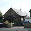 |
Ringmer 50°53′38″N 0°03′35″E / 50.8940°N 0.0597°E |
Congregational | – | The present red-brick building was converted into a house in 1995. It dates from 1914, and stands on the site of a predecessor which was built in 1834. | [238][239] |
| Congregational Chapel |
 |
South Heighton 50°48′27″N 0°03′28″E / 50.8074°N 0.0577°E |
Congregational | – | This small brick chapel in the village of South Heighton, now part of Newhaven, was erected in 1891. It fell out of use in the mid-20th century and is now in residential use. | [240] |
| Southover General Baptist Chapel | .jpg) |
Southover, Lewes 50°52′12″N 0°00′30″E / 50.8700°N 0.0082°E |
Baptist | II | This chapel was converted into a house in 1972 after more than 200 years as a place of worship. It was built in 1741 as the first Baptist chapel in the Lewes area, and retains its knapped flintwork, original hipped roof and door, which has been reset in a modern weatherboarded porch. | [10][109] [241] |
| St Bartholomew's Church | .jpg) |
Spithurst 50°56′21″N 0°01′42″E / 50.9391°N 0.0284°E |
Anglican | – | Henry Card, a local man, designed this Early English-style flint church in 1880 to serve the hamlet of Spithurst in Barcombe parish. It was declared redundant in 1994 but is still used by the Diocese of Chichester as a retreat and youth centre. | [33][224] [237][242] |
See also
Notes
References
- ↑ Vigar 1986, pp. 19–21.
- ↑ "Planning (Listed Buildings and Conservation Areas) Act 1990 (c. 9)". The UK Statute Law Database. Ministry of Justice. 24 May 1990. Retrieved 12 August 2009.
- ↑ "History of English Heritage". English Heritage. 2010. Retrieved 19 August 2011.
- ↑ "What does Listing mean?". English Heritage. 2008. Retrieved 2 August 2009.
- ↑ "Lewes District Council: News and local information". Lewes District Council. 2009. Archived from the original on 2 July 2009. Retrieved 12 August 2009.
- ↑ "Boundary Commission for England: Provisional Recommendations for West Sussex". Boundary Commission for England map of West Sussex. Office for National Statistics. 2000. Archived from the original (GIF) on 8 January 2007. Retrieved 12 August 2009.
- ↑ "Boundary Commission for England: Provisional Recommendations for East Sussex and Brighton and Hove". Boundary Commission for England map of East Sussex and Brighton and Hove. Office for National Statistics. 2000. Archived from the original (GIF) on 27 January 2007. Retrieved 12 August 2009.
- ↑ Salzman, L. F. (ed) (1940). "A History of the County of Sussex: Volume 7. The Rape and Honor of Lewes". Victoria County History of Sussex. British History Online. pp. 1–7. Retrieved 17 August 2009.
- ↑ Salzman, L. F. (ed) (1940). "A History of the County of Sussex: Volume 7. The borough of Lewes: Introduction and history". Victoria County History of Sussex. British History Online. pp. 7–19. Retrieved 12 August 2009.
- 1 2 3 4 5 6 7 8 9 10 11 12 13 Salzman, L. F. (ed) (1940). "A History of the County of Sussex: Volume 7. The borough of Lewes: Parliamentary, economic and religious history". Victoria County History of Sussex. British History Online. pp. 31–43. Retrieved 13 August 2009.
- 1 2 "Detailed Record: Jireh Chapel & Sunday School to north, Malling Street (east side), Lewes, Lewes, East Sussex". Images of England. English Heritage. 2007. Retrieved 12 August 2009.
- 1 2 "Church Finder". Free Presbyterian Church of Ulster. 1999. Retrieved 12 August 2009.
- 1 2 3 4 5 Salzman, L. F. (ed) (1940). "A History of the County of Sussex: Volume 7. Parishes: Ditchling". Victoria County History of Sussex. British History Online. pp. 102–109. Retrieved 12 August 2009.
- 1 2 3 4 Salzman, L. F. (ed) (1940). "A History of the County of Sussex: Volume 7. Parishes: Wivelsfield". Victoria County History of Sussex. British History Online. pp. 119–124. Retrieved 15 August 2009.
- ↑ "Area: Lewes (Local Authority) – Religion (UV15)". "Neighbourhood Statistics" website. Office for National Statistics. 18 November 2004. Retrieved 12 August 2009.
- ↑ "A little bit of history". Diocese of Chichester. 2012. Archived from the original on 19 January 2013. Retrieved 19 January 2013.
- 1 2 3 "Deaneries in the Diocese of Chichester". Diocese of Chichester. 2009. Retrieved 14 August 2009.
- ↑ "Benefice of Stanmer with Falmer". Diocese of Chichester. 2009. Retrieved 14 July 2009.
- ↑ "Rural Deanery of Brighton". Diocese of Chichester. 2009. Retrieved 14 August 2009.
- ↑ "Rural Deanery of Cuckfield". Diocese of Chichester. 2009. Retrieved 14 August 2009.
- ↑ "Rural Deanery of Hurst". Diocese of Chichester. 2009. Retrieved 14 August 2009.
- ↑ "Rural Deanery of Uckfield". Diocese of Chichester. 2009. Retrieved 14 August 2009.
- ↑ "Rural Deanery of Lewes and Seaford". Diocese of Chichester. 2009. Retrieved 14 August 2009.
- ↑ "Arundel Cathedral Parish". Diocese of Arundel and Brighton website. DABNet. 2009. Retrieved 14 August 2009.
- ↑ "Deaneries of the Diocese". Diocese of Arundel and Brighton website. DABNet. 2009. Retrieved 14 August 2009.
- ↑ "Lewes Christ Church". The United Reformed Church. 2008. Retrieved 16 August 2009.
- ↑ "Cross Way U/M". The United Reformed Church. 2008. Retrieved 16 August 2009.
- ↑ "Telscombe Cliffs". The United Reformed Church. 2008. Retrieved 16 August 2009.
- ↑ "Other URC Synods". URC Southern Synod. 10 August 2009. Retrieved 16 August 2009.
- ↑ "Welcome To The URC Southern Synod Website". URC Southern Synod. 10 August 2009. Archived from the original on 25 April 2009. Retrieved 16 August 2009.
- ↑ "About Us". Central Sussex United Area of the Methodist Church and the United Reformed Church. 2009. Retrieved 7 April 2010.
- ↑ "Area Churches". Central Sussex United Area of the Methodist Church and the United Reformed Church. 2009. Retrieved 7 April 2010.
- 1 2 3 4 5 Salzman, L. F. (ed) (1940). "A History of the County of Sussex: Volume 7. Parishes: Barcombe". Victoria County History of Sussex. British History Online. pp. 80–83. Retrieved 12 August 2009.
- ↑ "Detailed Record: The Parish Church of St Mary, Church Road, Barcombe, Lewes, East Sussex". Images of England. English Heritage. 2007. Retrieved 12 August 2009.
- ↑ Nairn & Pevsner 1965, p. 403.
- ↑ Vigar 1994, p. 25.
- 1 2 Allen, John (5 January 2009). "Barcombe – (1) St Francis and (2) St Mary". Sussex Parish Churches website. Sussex Parish Churches (www.sussexparishchurches.org). Retrieved 15 August 2009.
- ↑ Elleray 2004, p. 3.
- ↑ "History". Jubilee Christian Centre, Barcombe. 2011. Retrieved 17 October 2011.
- ↑ Registered in accordance with the Places of Worship Registration Act 1855 (Number in Worship Register: 68769; Name: Jubilee Christian Centre; Address: Hamsey Road, Barcombe; Denomination: Baptists). Retrieved 25 September 2012. (Archived version of list)
- ↑ The London Gazette: no. 48172. p. 6409. 29 April 1980. Retrieved 17 December 2012.
- ↑ "Detailed Record: The Parish Church of St Andrew, Beddingham, Lewes, East Sussex". Images of England. English Heritage. 2007. Retrieved 2 August 2009.
- ↑ Nairn & Pevsner 1965, p. 413.
- ↑ Vigar 1994, p. 27.
- ↑ "Detailed Record: St Andrew's Church, Bishopstone, Seaford, Lewes, East Sussex". Images of England. English Heritage. 2007. Retrieved 2 August 2009.
- ↑ Nairn & Pevsner 1965, p. 418.
- 1 2 3 Salzman, L. F. (ed) (1940). "A History of the County of Sussex: Volume 7. Parishes: Chailey". Victoria County History of Sussex. British History Online. pp. 94–98. Retrieved 12 August 2009.
- ↑ "Detailed Record: The Parish Church of St Peter, Chailey, Lewes, East Sussex". Images of England. English Heritage. 2007. Retrieved 2 August 2009.
- ↑ Nairn & Pevsner 1965, p. 469.
- ↑ "Detailed Record: Church of St Thomas at Cliffe (formerly listed as Church of St Thomas-a-Becket in the Cliffe), Cliffe High Street (north side), Lewes, Lewes, East Sussex". Images of England. English Heritage. 2007. Retrieved 2 August 2009.
- ↑ Nairn & Pevsner 1965, pp. 553–554.
- ↑ Nairn & Pevsner 1965, p. 559.
- 1 2 3 4 5 6 7 8 9 10 11 Elleray 2004, p. 38.
- ↑ Registered in accordance with the Places of Worship Registration Act 1855 (Number in Worship Register: 15521; Name: Jireh Chapel; Address: Malling Street, Cliffe, Lewes; Denomination: Calvinists). Retrieved 25 September 2012. (Archived version of list)
- ↑ "Detailed Record: Church of St Leonard, Heighton Road, Denton, Newhaven, Lewes, East Sussex". Images of England. English Heritage. 2007. Retrieved 2 August 2009.
- ↑ Nairn & Pevsner 1965, p. 480.
- 1 2 Allen, John (22 August 2011). "Denton – St Leonard". Sussex Parish Churches website. Sussex Parish Churches (www.sussexparishchurches.org). Retrieved 2 September 2011.
- ↑ "Detailed Record: The Parish Church of St Margaret, West Street (north side), Ditchling, Lewes, East Sussex". Images of England. English Heritage. 2007. Retrieved 2 August 2009.
- ↑ Nairn & Pevsner 1965, pp. 481–482.
- 1 2 3 4 Harris, Roland B. (June 2005). "Ditchling Historic Character Assessment" (PDF). Sussex Extensive Urban Survey (EUS). East Sussex County Council, West Sussex County Council, Brighton and Hove City Council and English Heritage. Retrieved 12 August 2009.
- 1 2 "Ditchling Conservation Area Character Appraisal" (PDF). Lewes District Council (Planning and Environmental Services Department). April 2007. Retrieved 12 August 2009.
- ↑ Registered in accordance with the Places of Worship Registration Act 1855 (Number in Worship Register: 73137; Name: Emmanuel Chapel; Address: 20 South Street, Ditchling; Denomination: Christians not otherwise designated). Retrieved 25 September 2012. (Archived version of list)
- ↑ The London Gazette: no. 45759. p. 10085. 22 August 1972. Retrieved 1 November 2012.
- ↑ "Ditchling Quaker Meeting". Ditchling Quakers website. Ditchling Quaker Meeting. 2009. Retrieved 12 August 2009.
- ↑ Registered in accordance with the Places of Worship Registration Act 1855 (Number in Worship Register: 71082; Name: Friends Meeting House; Address: East Gardens, Ditchling; Denomination: Friends). Retrieved 25 September 2012. (Archived version of list)
- ↑ "Detailed Record: The Old Meeting House (Unitarian and Free Christian Church) and the house adjoining to south, East End Lane (south west side), Ditchling, Lewes, East Sussex". Images of England. English Heritage. 2007. Retrieved 3 August 2009.
- 1 2 Elleray 2004, p. 19.
- ↑ Nairn & Pevsner 1965, p. 482.
- ↑ Stell 2002, p. 341.
- ↑ Registered in accordance with the Places of Worship Registration Act 1855 (Number in Worship Register: 35608; Name: The Old Meeting House; Address: 2 The Twitten, Ditchling; Denomination: Unitarian and Free Church). Retrieved 25 September 2012. (Archived version of list)
- ↑ "Detailed Record: The Parish Church of St Peter, Blatchington Hill, Seaford, Lewes, East Sussex". Images of England. English Heritage. 2007. Retrieved 3 August 2009.
- ↑ Nairn & Pevsner 1965, pp. 482–483.
- 1 2 3 Elleray 2004, p. 48.
- ↑ Registered in accordance with the Places of Worship Registration Act 1855 (Number in Worship Register: 73170; Name: Seaford Baptist Church and Halls; Address: Belgrave Road, Seaford; Denomination: Baptists). Retrieved 25 September 2012. (Archived version of list)
- ↑ "Detailed Record: The Parish Church, Chapel Lane, East Chiltington, Lewes, East Sussex". Images of England. English Heritage. 2007. Retrieved 3 August 2009.
- ↑ Salzman, L. F. (ed) (1940). "A History of the County of Sussex: Volume 7. Parishes: East Chiltington". Victoria County History of Sussex. British History Online. pp. 98–102. Retrieved 12 August 2009.
- ↑ Nairn & Pevsner 1965, pp. 490–491.
- ↑ "Detailed Record: The Parish Church of St Lawrence (sic), East Street, Falmer, Lewes, East Sussex". Images of England. English Heritage. 2007. Retrieved 3 August 2009.
- ↑ Salzman, L. F. (ed) (1940). "A History of the County of Sussex: Volume 7. Parishes: Falmer". Victoria County History of Sussex. British History Online. pp. 223–227. Retrieved 12 August 2009.
- ↑ Allen, John (14 January 2009). "Falmer – St Laurence". Sussex Parish Churches website. Sussex Parish Churches (www.sussexparishchurches.org). Retrieved 15 August 2009.
- ↑ "Detailed Record: The Parish Church of St Mary the Virgin, Glynde, Lewes, East Sussex". Images of England. English Heritage. 2007. Retrieved 3 August 2009.
- ↑ Elleray 2004, p. 25.
- ↑ Nairn & Pevsner 1965, p. 510.
- ↑ Worsley, Giles (September 2004). "Oxford DNB article: Robinson, Sir Thomas". Oxford Dictionary of National Biography. Oxford University Press. doi:10.1093/ref:odnb/23879. Retrieved 15 August 2009. (subscription or UK public library membership required)
- 1 2 Salzman, L. F. (ed) (1940). "A History of the County of Sussex: Volume 7. Parishes: Hamsey". Victoria County History of Sussex. British History Online. pp. 83–87. Retrieved 13 August 2009.
- ↑ "Heritage Gateway Listed Buildings Online — The Parish Church of St Peter, Hamsey, Lewes, East Sussex". Heritage Gateway website. Heritage Gateway (English Heritage, Institute of Historic Building Conservation and ALGAO:England). 2006. Retrieved 13 August 2009.
- ↑ Nairn & Pevsner 1965, p. 516.
- ↑ Salzman, L. F. (ed) (1940). "A History of the County of Sussex: Volume 7. Parishes: Iford". Victoria County History of Sussex. British History Online. pp. 52–57. Retrieved 13 August 2009.
- ↑ "Detailed Record: The Parish Church of St Nicholas, Iford, Lewes, East Sussex". Images of England. English Heritage. 2007. Retrieved 3 August 2009.
- ↑ Nairn & Pevsner 1965, p. 544.
- ↑ Salzman, L. F. (ed) (1940). "A History of the County of Sussex: Volume 7. Parishes: Kingston near Lewes". Victoria County History of Sussex. British History Online. pp. 57–60. Retrieved 13 August 2009.
- ↑ "Detailed Record: The Parish Church of St Pancras, The Street (north side), Kingston near Lewes, Lewes, East Sussex". Images of England. English Heritage. 2007. Retrieved 3 August 2009.
- ↑ Nairn & Pevsner 1965, p. 547.
- ↑ Registered in accordance with the Places of Worship Registration Act 1855 (Number in Worship Register: 58661; Name: Catholic Church of St Pancras; Address: St Ann's, High Street, Lewes; Denomination: Roman Catholics). Retrieved 25 September 2012. (Archived version of list)
- ↑ "Detailed Record: Church of St Anne, Western Road (north side), Lewes, Lewes, East Sussex". Images of England. English Heritage. 2007. Retrieved 13 August 2009.
- ↑ Nairn & Pevsner 1965, pp. 551–552.
- ↑ "Detailed Record: Church of St Michael and railings, High Street (north side), Lewes, Lewes, East Sussex". Images of England. English Heritage. 2007. Retrieved 13 August 2009.
- 1 2 Nairn & Pevsner 1965, p. 553.
- ↑ "Detailed Record: Church of St John sub Castro, Abinger Place (north side), Lewes, Lewes, East Sussex". Images of England. English Heritage. 2007. Retrieved 13 August 2009.
- ↑ Nairn & Pevsner 1965, p. 552.
- 1 2 3 Nairn & Pevsner 1965, p. 554.
- ↑ Stell 2002, p. 347.
- 1 2 3 Registered in accordance with the Places of Worship Registration Act 1855 (Number in Worship Register: 1; Name: Baptist Chapel; Address: Eastgate Street, Lewes; Denomination: Baptists). Retrieved 25 September 2012. (Archived version of list)
- ↑ "Kingdom Hall Of Jehovah's Witnesses in Lewes". Touch Local Ltd. 2010. Retrieved 6 February 2010.
- ↑ "This month's regular events". Lewes District Council. 2010. Retrieved 6 February 2010.
- ↑ Harris, Roland B. (March 2005). "Lewes Historic Character Assessment Report" (PDF). Sussex Extensive Urban Surveys (EUS). Lewes District Council in association with English Heritage. p. 47. Retrieved 7 February 2010.
- ↑ Registered in accordance with the Places of Worship Registration Act 1855 (Number in Worship Register: 77501; Name: Kingdom Hall; Address: Station Street, Lewes; Denomination: Jehovah's Witnesses). Retrieved 25 September 2012. (Archived version of list)
- 1 2 "Congregation Meeting Search (State/Province: East Sussex)". jw.org (Jehovah's Witnesses) Congregation Finder app. Watch Tower Bible and Tract Society of Pennsylvania, Inc. 2012. Retrieved 28 November 2012. (Select "Search" then "Expand all details".)
- 1 2 Elleray 2004, p. 39.
- ↑ "Detailed Record: Friends' Meeting House, Friar's Walk (north side), Lewes, Lewes, East Sussex". Images of England. English Heritage. 2007. Retrieved 13 August 2009.
- ↑ Stell 2002, p. 350.
- ↑ Registered in accordance with the Places of Worship Registration Act 1855 (Number in Worship Register: 4502; Name: Friends' Meeting House; Address: Friar's Walk, All Saints, Lewes; Denomination: Quakers). Retrieved 25 September 2012. (Archived version of list)
- ↑ "English Heritage Review of Diocesan Churches 2005 (Extract): St Pancras, Lewes" (PDF). English Heritage. 2005. Retrieved 15 August 2009.
- ↑ "Detailed Record: Westgate Chapel, High Street (south side), Lewes, Lewes, East Sussex". Images of England. English Heritage. 2007. Retrieved 13 August 2009.
- ↑ Stell 2002, pp. 351–352.
- ↑ "Christ Church, Prince Edwards Road, Lewes". Christ Church, Lewes. 2009. Retrieved 13 August 2009.
- ↑ "Christ Church, Lewes". ESCIS website. East Sussex County Council Library and Information Services/Brighton and Hove City Libraries. 30 June 2009. Retrieved 16 August 2009.
- ↑ Registered in accordance with the Places of Worship Registration Act 1855 (Number in Worship Register: 65045; Name: Christ Church, Lewes (United Reformed/Methodist); Address: Prince Edward's Road, Lewes; Denomination: United Reformed Church). Retrieved 25 September 2012. (Archived version of list)
- ↑ "Services". St Anne's Church, Lewes. 2011. Retrieved 24 September 2011.
- ↑ "St Mary, Lewes". A Church Near You website. Archbishops' Council. 2010. Retrieved 24 September 2011.
- ↑ "PAR537: Parish of Lewes St Mary". Summary of records at East Sussex Record Office. The National Archives. 2011. Retrieved 6 June 2012.
- ↑ "St Mary's Church Hall, Lewes". ESCIS website. East Sussex County Council Library and Information Services/Brighton and Hove City Libraries. 11 May 2012. Retrieved 6 June 2012.
- 1 2 3 4 5 6 7 Salzman, L. F. (ed) (1940). "A History of the County of Sussex: Volume 7. Parishes: Newhaven". Victoria County History of Sussex. British History Online. pp. 62–65. Retrieved 13 August 2009.
- ↑ "Detailed Record: Church of St Michael and All Angels, Church Hill (east side), Newhaven, Lewes, East Sussex". Images of England. English Heritage. 2007. Retrieved 13 August 2009.
- ↑ Registered in accordance with the Places of Worship Registration Act 1855 (Number in Worship Register: 72543; Name: St Michael's Church (shared by Anglicans and Methodists); Address: Church Hill, Newhaven; Denomination: Methodist Church). Retrieved 25 September 2012. (Archived version of list)
- 1 2 3 4 5 6 7 8 Elleray 2004, p. 42.
- ↑ Registered in accordance with the Places of Worship Registration Act 1855 (Number in Worship Register: 38774; Name: Baptist Chapel; Address: Junction of Church Hill and Brighton Road, Newhaven; Denomination: Baptists). Retrieved 25 September 2012. (Archived version of list)
- ↑ "Elim Pentecostal Community Church – Churches". Newhaven Town website. Seahaven FM. 2007–2009. Retrieved 13 August 2009.
- ↑ The London Gazette: no. 43972. p. 5407. 5 May 1966. Retrieved 3 July 2012.
- ↑ Registered in accordance with the Places of Worship Registration Act 1855 (Number in Worship Register: 69782; Name: Elim Church; Address: Meeching Rise, Newhaven; Denomination: Elim Foursquare Gospel Alliance). Retrieved 25 September 2012. (Archived version of list)
- ↑ "English Heritage Review of Diocesan Churches 2005 (Extract): The Sacred Heart, Newhaven" (PDF). English Heritage. 2005. Retrieved 15 August 2009.
- ↑ Registered in accordance with the Places of Worship Registration Act 1855 (Number in Worship Register: 41249; Name: Sacred Heart Catholic Church; Address: Fort Road, Newhaven; Denomination: Roman Catholics). Retrieved 25 September 2012. (Archived version of list)
- 1 2 3 Salzman, L. F. (ed) (1940). "A History of the County of Sussex: Volume 7. Parishes: Newick". Victoria County History of Sussex. British History Online. pp. 87–91. Retrieved 15 August 2009.
- ↑ "Detailed Record: The Parish Church of St Mary, Church Road (east side), Newick, Lewes, East Sussex". Images of England. English Heritage. 2007. Retrieved 15 August 2009.
- ↑ "Newick (Church Road) Conservation Area Appraisal" (PDF). Lewes District Council Planning and Environmental Services Department. May 2007. Retrieved 15 August 2009.
- ↑ Nairn & Pevsner 1965, p. 571.
- ↑ "Newick Evangelical Free Church". Newick Village website. The Parish Council of Newick. 2008. Retrieved 16 August 2009.
- 1 2 Lindsey 1983, p. 36.
- ↑ Registered in accordance with the Places of Worship Registration Act 1855 (Number in Worship Register: 33715; Name: Mission Hall; Address: Newick; Denomination: Unsectarian). Retrieved 25 September 2012. (Archived version of list)
- ↑ "Detailed Record: Church of St Peter, Offham, Hamsey, Lewes, East Sussex". Images of England. English Heritage. 2007. Retrieved 15 August 2009.
- ↑ Nairn & Pevsner 1965, p. 576.
- ↑ Elleray 2004, p. 43.
- 1 2 3 Salzman, L. F. (ed) (1940). "A History of the County of Sussex: Volume 7. Parishes: Piddinghoe". Victoria County History of Sussex. British History Online. pp. 66–69. Retrieved 15 August 2009.
- ↑ Elleray 2004, p. 44.
- 1 2 3 4 5 "Schools & Churches". Peacehaven Town Council. 2009. Retrieved 15 August 2009.
- 1 2 Harris, Roland B. (November 2004). "Peacehaven Historic Character Assessment" (PDF). Sussex Extensive Urban Survey (EUS). East Sussex County Council, West Sussex County Council, Brighton and Hove City Council and English Heritage. Retrieved 16 August 2009.
- ↑ Registered in accordance with the Places of Worship Registration Act 1855 (Number in Worship Register: 70624; Name: Evangelical Free Church; Address: Mayfield Avenue, South Coast Road; Denomination: Independent Evangelical Church). Retrieved 25 September 2012. (Archived version of list)
- ↑ Registered in accordance with the Places of Worship Registration Act 1855 (Number in Worship Register: 69701; Name: Kingdom Hall; Address: Junction of South Coast Road and Sunview Avenue, Peacehaven; Denomination: Jehovah's Witnesses). Retrieved 25 September 2012. (Archived version of list)
- ↑ Registered in accordance with the Places of Worship Registration Act 1855 (Number in Worship Register: 69221; Name: Church of the Immaculate Conception; Address: Edith Avenue, Peacehaven; Denomination: Roman Catholics). Retrieved 25 September 2012. (Archived version of list)
- ↑ The London Gazette: no. 43162. p. 9457. 19 November 1963. Retrieved 7 December 2012.
- ↑ "Detailed Record: The Parish Church of St John, Piddinghoe, Lewes, East Sussex". Images of England. English Heritage. 2007. Retrieved 15 August 2009.
- ↑ Nairn & Pevsner 1965, p. 582.
- 1 2 Salzman, L. F. (ed) (1940). "A History of the County of Sussex: Volume 7. Parishes: Plumpton". Victoria County History of Sussex. British History Online. pp. 66–69. Retrieved 15 August 2009.
- ↑ "The Parish Church of St Michael and All Angels, Plumpton, Lewes, East Sussex". The National Heritage List for England. English Heritage. 2011. Retrieved 30 September 2011.
- ↑ Nairn & Pevsner 1965, pp. 583–584.
- ↑ Nairn & Pevsner 1965, p. 584.
- ↑ Elleray 2004, p. 45.
- ↑ "Detailed Record: The Parish Church of St Mary the Virgin, Church Lane, Ringmer, Lewes, East Sussex". Images of England. English Heritage. 2007. Retrieved 15 August 2009.
- ↑ Nairn & Pevsner 1965, pp. 587–588.
- ↑ Salzman, L. F. (ed) (1940). "A History of the County of Sussex: Volume 7. Parishes: Rodmell". Victoria County History of Sussex. British History Online. pp. 69–73. Retrieved 15 August 2009.
- ↑ "Detailed Record: The Parish Church of St Peter, Rodmell, Lewes, East Sussex". Images of England. English Heritage. 2007. Retrieved 15 August 2009.
- ↑ Nairn & Pevsner 1965, p. 590.
- ↑ "Detailed Record: The Parish Church of St Leonard, Church Street, Seaford, Lewes, East Sussex". Images of England. English Heritage. 2007. Retrieved 15 August 2009.
- 1 2 Nairn & Pevsner 1965, p. 603.
- ↑ "Appendix 7 – Survey Work for Seaford Town Centre as at Spring 2004" (PDF). Seaford Town Centre study. Lewes District Council. 2004. Retrieved 5 September 2011.
- ↑ The London Gazette: no. 51027. p. 10222. 12 August 1987. Retrieved 3 July 2012.
- ↑ Registered in accordance with the Places of Worship Registration Act 1855 (Number in Worship Register: 76411; Name: Kingdom Hall; Address: West Street, Seaford; Denomination: Jehovah's Witnesses). Retrieved 25 September 2012. (Archived version of list)
- ↑ "Congregation Meeting Search (State/Province: East Sussex)". jw.org (Jehovah's Witnesses) Congregation Finder app. Watch Tower Bible and Tract Society of Pennsylvania, Inc. 2012. Retrieved 28 November 2012. (Select "Search" then "Expand all details", then see Page 2 for Seaford.)
- 1 2 Elleray 2004, p. 49.
- 1 2 "Cross Way: A partnership between Seaford Methodist and United Reformed Churches". ESCIS website. East Sussex County Council Library and Information Services/Brighton and Hove City Libraries. 7 February 2008. Retrieved 16 August 2009.
- ↑ Registered in accordance with the Places of Worship Registration Act 1855 (Number in Worship Register: 39852; Name: Cross Way, Methodist and United Reformed Church; Address: Steyne Road, Seaford; Denomination: Methodist Church). Retrieved 25 September 2012. (Archived version of list)
- ↑ "English Heritage Review of Diocesan Churches 2005 (Extract): St Thomas More, Seaford" (PDF). English Heritage. 2005. Retrieved 15 August 2009.
- ↑ Registered in accordance with the Places of Worship Registration Act 1855 (Number in Worship Register: 56568; Name: Church of St Thomas More; Address: Sutton Road, Seaford; Denomination: Roman Catholics). Retrieved 25 September 2012. (Archived version of list)
- ↑ "Seaford Independent Spiritualist Church". Seaford Independent Spiritualist Church. 2011. Retrieved 21 September 2011.
- ↑ "Seaford Independent Spiritualist Church". ESCIS website. East Sussex County Council Library and Information Services/Brighton and Hove City Libraries. 2011. Retrieved 21 September 2011.
- ↑ "Services of Worship". Cross Way: A Partnership Between Seaford's Methodist and URC Churches. Cross Way Seaford. 2009. Retrieved 16 August 2009.
- ↑ Stell 2002, p. 354.
- ↑ Registered in accordance with the Places of Worship Registration Act 1855 (Number in Worship Register: 24909; Name: Seaford United Reformed Church; Address: Clinton Place, Seaford; Denomination: United Reformed Church). Retrieved 25 September 2012. (Archived version of list)
- ↑ "Chailey Free Church". ESCIS website. East Sussex County Council Library and Information Services/Brighton and Hove City Libraries. 12 February 2009. Retrieved 16 August 2009.
- ↑ The London Gazette: no. 52874. p. 5453. 26 March 1992. Retrieved 4 May 2012.
- ↑ The London Gazette: no. 52869. p. 5161. 23 March 1992. Retrieved 7 June 2012.
- ↑ Registered in accordance with the Places of Worship Registration Act 1855 (Number in Worship Register: 78500; Name: Chailey Free Church Chapel; Address: South Common, South Chailey; Denomination: Undenominational Evangelical). Retrieved 25 September 2012. (Archived version of list)
- ↑ "Detailed Record: Church of St Michael, Church Lane (north side), Malling, Lewes, Lewes, East Sussex". Images of England. English Heritage. 2007. Retrieved 15 August 2009.
- ↑ Nairn & Pevsner 1965, pp. 608–609.
- ↑ "King's Church Lewes: Who are we?". King's Church, Lewes. 2009. Retrieved 6 February 2010.
- ↑ "King's Church Lewes: The latest news on our new building project". King's Church, Lewes. 2009. Retrieved 6 February 2010.
- ↑ Salzman, L. F. (ed) (1940). "A History of the County of Sussex: Volume 7. Parishes: Southease". Victoria County History of Sussex. British History Online. pp. 73–76. Retrieved 15 August 2009.
- ↑ "Detailed Record: The Parish Church, Southease, Lewes, East Sussex". Images of England. English Heritage. 2007. Retrieved 15 August 2009.
- ↑ Nairn & Pevsner 1965, p. 608.
- ↑ Salzman, L. F. (ed) (1940). "A History of the County of Sussex: Volume 7. Parishes: Southover". Victoria County History of Sussex. British History Online. pp. 45–50. Retrieved 16 August 2009.
- ↑ "Detailed Record: Church of St John the Baptist, Southover High Street (south side), Lewes, Lewes, East Sussex". Images of England. English Heritage. 2007. Retrieved 15 August 2009.
- ↑ Nairn & Pevsner 1965, pp. 552–553.
- ↑ Salzman, L. F. (ed) (1940). "A History of the County of Sussex: Volume 7. Parishes: Streat". Victoria County History of Sussex. British History Online. pp. 113–115. Retrieved 15 August 2009.
- ↑ "Detailed Record: The Parish Church, Streat, Lewes, East Sussex". Images of England. English Heritage. 2007. Retrieved 15 August 2009.
- ↑ Nairn & Pevsner 1965, pp. 610–611.
- ↑ "The Parish of Sutton with Seaford: St Luke's Church History". The Parish of Sutton with Seaford. 2011. Retrieved 5 September 2011.
- ↑ "Seaford Community Church". Mark Woodgate (Seaford Community Church). 2007. Retrieved 15 August 2009.
- ↑ The London Gazette: no. 44852. p. 5295. 20 May 1969. Retrieved 13 June 2012.
- ↑ Registered in accordance with the Places of Worship Registration Act 1855 (Number in Worship Register: 71765; Name: Seaford Community Church; Address: 117 Vale Road, Seaford; Denomination: Christians not otherwise designated). Retrieved 25 September 2012. (Archived version of list)
- ↑ "Chyngton Methodist Church". ESCIS website. East Sussex County Council Library and Information Services/Brighton and Hove City Libraries. 1 April 2009. Retrieved 15 August 2009.
- ↑ Registered in accordance with the Places of Worship Registration Act 1855 (Number in Worship Register: 65048; Name: Chyngton Methodist Church; Address: Millberg Road, Seaford; Denomination: Methodist Church). Retrieved 25 September 2012. (Archived version of list)
- ↑ "Detailed Record: The Parish Church of St Mary, Tarring Neville, Lewes, East Sussex". Images of England. English Heritage. 2007. Retrieved 15 August 2009.
- ↑ Nairn & Pevsner 1965, p. 611.
- ↑ Salzman, L. F. (ed) (1940). "A History of the County of Sussex: Volume 7. Parishes: Telscombe". Victoria County History of Sussex. British History Online. pp. 76–78. Retrieved 15 August 2009.
- ↑ "Detailed Record: The Parish Church of St Lawrence, Telscombe, Lewes, East Sussex". Images of England. English Heritage. 2007. Retrieved 15 August 2009.
- ↑ Nairn & Pevsner 1965, pp. 611–612.
- ↑ Registered in accordance with the Places of Worship Registration Act 1855 (Number in Worship Register: 53910; Name: Telscombe Cliffs United Reformed Church; Address: Buckhurst Road, Broomfield Avenue, Telscombe; Denomination: United Reformed Church). Retrieved 25 September 2012. (Archived version of list)
- ↑ "Detailed Record: The Parish Church of St Peter, Firle, Lewes, East Sussex". Images of England. English Heritage. 2007. Retrieved 15 August 2009.
- ↑ Nairn & Pevsner 1965, p. 623.
- ↑ Salzman, L. F. (ed) (1940). "A History of the County of Sussex: Volume 7. Parishes: Westmeston". Victoria County History of Sussex. British History Online. pp. 116–119. Retrieved 15 August 2009.
- ↑ "Detailed Record: The Parish Church of St Martin, Westmeston, Lewes, East Sussex". Images of England. English Heritage. 2007. Retrieved 15 August 2009.
- ↑ Nairn & Pevsner 1965, p. 628.
- ↑ "Detailed Record: The Parish Church of St Peter and St John the Baptist, Church Lane, Wivelsfield, Lewes, East Sussex". Images of England. English Heritage. 2007. Retrieved 15 August 2009.
- 1 2 Elleray 2004, p. 56.
- ↑ "Detailed Record: The Strict and Particular Baptist Chapel, Ditchling Road, Wivelsfield, Lewes, East Sussex". Images of England. English Heritage. 2007. Retrieved 15 August 2009.
- ↑ Stell 2002, p. 359.
- ↑ Registered in accordance with the Places of Worship Registration Act 1855 (Number in Worship Register: 15568; Name: Bethel Chapel; Address: Near Jacob's Post, Wivelsfield; Denomination: Particular Calvinistic Baptists). Retrieved 25 September 2012. (Archived version of list)
- ↑ "Detailed Record: Ote Hall Chapel, Ditchling Road, Wivelsfield, Lewes, East Sussex". Images of England. English Heritage. 2007. Retrieved 15 August 2009.
- ↑ Stell 2002, p. 358.
- ↑ Registered in accordance with the Places of Worship Registration Act 1855 (Number in Worship Register: 33050; Name: Ote Hall Chapel; Address: Near More House, Wivelsfield; Denomination: Independents). Retrieved 25 September 2012. (Archived version of list)
- ↑ "The Church of Jesus Christ of Latter-day Saints: Chapel Locator". The Church of Jesus Christ of Latter-day Saints website. Intellectual Reserve. 2006. Retrieved 15 August 2009.
- ↑ "Application Details (LW/99/1153)". Lewes District Council planning application. Lewes District Council/CAPS Solutions Ltd. 2005. Retrieved 15 August 2009.
- ↑ Registered in accordance with the Places of Worship Registration Act 1855 (Number in Worship Register: 81367; Name: The Church of Jesus Christ of Latter-day Saints Haywards Heath Chapel; Address: North Common Road, Wivelsfield Green; Denomination: Latter-day Saints). Retrieved 25 September 2012. (Archived version of list)
- 1 2 3 "Discovering Barcombe and Hamsey: Contrasting Communities? – Project Introduction". Sussex Archaeological Society community research project: Barcombe and Hamsey. Sussex Archaeological Society. 2007. Retrieved 15 August 2009.
- ↑ Atlay, J.B.; Stevens, Robert (2004). "Oxford DNB article: Grantham, Sir William". Oxford Dictionary of National Biography. Oxford University Press. doi:10.1093/ref:odnb/33519. Retrieved 15 August 2009. (subscription or UK public library membership required)
- ↑ Registered in accordance with the Places of Worship Registration Act 1855 (Number in Worship Register: 61611; Name: Mission Hall; Address: Cooksbridge Road, Barcombe; Denomination: People who object to be designated). Retrieved 25 September 2012. (Archived version of list)
- ↑ "House for sale in Shortgate Lane, Laughton, Lewes, East Sussex – 5 bedrooms, 3 reception rooms, 3 bathrooms". Primelocation. The Digital Property Group. 2001–2011. Retrieved 16 September 2011.
- ↑ The London Gazette: no. 48775. p. 13546. 26 October 1981. Retrieved 27 April 2012.
- ↑ "Detailed Record: All Saint's Community Centre, Friar's Walk (north side), Lewes, Lewes, East Sussex". Images of England. English Heritage. 2007. Retrieved 15 August 2009.
- ↑ Nairn & Pevsner 1965, p. 551.
- 1 2 3 4 5 Harris, Roland B. (November 2004). "Newhaven Historic Character Assessment" (PDF). Sussex Extensive Urban Survey (EUS). East Sussex County Council, West Sussex County Council, Brighton and Hove City Council and English Heritage. Retrieved 2 September 2011.
- ↑ The London Gazette: no. 45966. p. 5484. 1 May 1973. Retrieved 3 July 2012.
- ↑ "Detailed Record: Zion Chapel, Western Road, Newick, Lewes, East Sussex". Images of England. English Heritage. 2007. Retrieved 15 August 2009.
- ↑ "Application Details (LW/01/0590)". Lewes District Council planning application. Lewes District Council/CAPS Solutions Ltd. 2005. Retrieved 16 August 2009.
- ↑ Elleray 2004, p. 15.
- ↑ "Detailed Record: Church of Our Lady, Queen of Heaven, North Common, North Chailey, Lewes, East Sussex". Images of England. English Heritage. 2007. Retrieved 15 August 2009.
- 1 2 "The Church of England Statistics & Information: Lists (by diocese) of closed church buildings as at October 2012" (PDF). Church of England. 1 October 2012. Archived from the original on 30 January 2013. Retrieved 30 January 2013.
- ↑ Elleray 2004, p. 46.
- ↑ "Application Details (LW/05/9696)". Lewes District Council planning application. Lewes District Council/CAPS Solutions Ltd. 2005. Retrieved 16 August 2009.
- ↑ Elleray 2004, p. 50.
- ↑ "Detailed Record: No 19 Eastport Lane (The Old Meeting), Southover, Lewes, East Sussex". Images of England. English Heritage. 2007. Retrieved 15 August 2009.
- ↑ Nairn & Pevsner 1965, p. 609.
Bibliography
- Elleray, D. Robert (2004). Sussex Places of Worship. Worthing: Optimus Books. ISBN 0-9533132-7-1.
- Lindsey, Joyce (1983). Newick: The Story of a Sussex Village c. 900–1950. Newick: Newick Parish Council.
- Nairn, Ian; Pevsner, Nikolaus (1965). The Buildings of England: Sussex. Harmondsworth: Penguin Books. ISBN 0-14-071028-0.
- Pé, Diana (2006). Mid Sussex Church Walks. PP (Pé Publishing). ISBN 0-9543690-2-5.
- Stell, Christopher (2002). Nonconformist Chapels and Meeting-houses in Eastern England. Swindon: English Heritage. ISBN 1-873592-50-7.
- Vigar, John E. (1986). Exploring Sussex Churches. Rainham: Meresborough Books. ISBN 0-948193-09-3.
- Vigar, John (1994). The Lost Villages of Sussex. Stanbridge: The Dovecote Press Ltd. ISBN 1-874336-29-6.
Places of worship in Sussex (by district) | ||
|---|---|---|
| East Sussex | | |
| West Sussex | ||
| Demolished | ||
| Cathedrals | ||